Interstate 39 (I-39) is a highway in the Midwestern United States. I-39 runs from Normal, Illinois at I-55 to Wisconsin Highway 29 (WIS 29) in Rib Mountain, Wisconsin, approximately six miles (9.7 km) southwest of Wausau. I-39 was designed to replace U.S. Route 51 (US 51), which in the early 1980s was one of the busiest two-lane highways in the United States. I-39 was built in the 1980s and 1990s. In Illinois, the route has a total length of 140.82 miles (226.63 km). In Wisconsin, I-39 has a distance of 182 miles (293 km). With the exception of an eight-mile (13 km) segment around Portage, the Interstate shares a route with at least one other route number in I-39's entirety. From Rockford to Portage, I-39 is concurrent with I-90. I-94 joins the pair in Madison until Portage. At 29 miles (47 km) in length, this concurrency of three Interstates is the longest in the country. From Portage northward, US 51 is co-signed with the Interstate and has exit numbers based on its mileage.

Wood County is a county located in the U.S. state of Wisconsin. As of the 2010 census, the population was 74,749. Its county seat is Wisconsin Rapids. The county is named after Joseph Wood, a member of the Wisconsin State Assembly.

Portage County is a county in the U.S. state of Wisconsin. As of the 2010 census, the population was 70,019. Its county seat is Stevens Point.

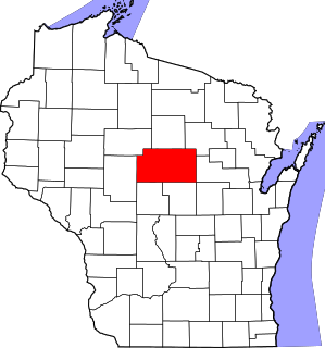
Marathon County is a county located in the U.S. state of Wisconsin. As of the 2010 census, the population was 134,063. Its county seat is Wausau. It was founded in 1850, created from a portion of Portage County. At that time the county stretched to the northern border with the upper Michigan peninsula. It is named after the battlefield at Marathon, Greece.

Lincoln County is a county located in the U.S. state of Wisconsin. As of the 2010 census, the population was 28,867. Its county seat is Merrill. The county was created in 1875 and named after President Abraham Lincoln.

Rothschild is a village in Marathon County, Wisconsin, United States. It is part of the Wausau, Wisconsin Metropolitan Statistical Area. The population was 5,269 at the 2010 census. Rothschild is the northern terminus of Interstate 39, which starts in Normal, Illinois.

Schofield is a city in Marathon County, Wisconsin, United States. It is part of the Wausau, Wisconsin Metropolitan Statistical Area. The population was 2,169 at the 2010 census. The city was named for Dr. William Scholfield, who came to the area in the 1851 to open a sawmill. The city has since dropped the "L" from its name.

Wausau is a city in and the county seat of Marathon County, Wisconsin, United States. The Wisconsin River divides the city into east and west. The city's suburbs include Schofield, Weston, Maine, Rib Mountain, Kronenwetter, and Rothschild.

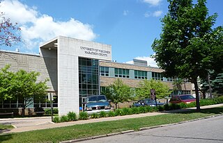
The University of Wisconsin–Stevens Point at Wausau, one of the University of Wisconsin Colleges, is a two-year campus of the University of Wisconsin System. It is located near downtown Wausau, Wisconsin, United States, and adjacent to 78-acre (32 ha) Marathon Park.
State Trunk Highway 52 is a state highway in the U.S. state of Wisconsin. It runs east–west in central and northeastern Wisconsin from Wabeno to Wausau. It is one of four state highways that also serve Antigo.

The Marathon County Public Library (MCPL) is a consolidated county library with nine locations in Marathon County, Wisconsin, U.S.A. Its headquarters are in Wausau. The library has its origins in the Wausau Free Public Library, which was founded in April 1907.

Wausau East High School is a public secondary school in Wausau, Wisconsin. It serves grades 9-12 for the Wausau School District.

The Marathon County Historical Museum is museum located in Wausau, Marathon County, Wisconsin, United States. It is located in the Cyrus Carpenter Yawkey House, a house listed on the National Register of Historic Places in 1974. The house is a significant example of Classical Revival architecture.

This is a list of the National Register of Historic Places listings in Marathon County, Wisconsin. It is intended to provide a comprehensive listing of entries in the National Register of Historic Places that are located in Marathon County, Wisconsin. The locations of National Register properties for which the latitude and longitude coordinates are included below may be seen in a map.
William Henry Mylrea was an American lawyer.
John H. Robinson is an American politician and businessman, he was the 40th Mayor of Wausau, Wisconsin, and represented Wausau for four terms in the Wisconsin State Assembly.
Lewis (Louis) H. Cook was an American farmer and politician.

August F. Marquardt was an American businessman and politician.

Henry Miller was an American politician, businessman, and jurist.
Burton Millard was an American politician and machinist.


