
North Cascades National Park is an American national park in the state of Washington. At more than 500,000 acres (200,000 ha), North Cascades National Park is the largest of the three National Park Service units that comprise the North Cascades National Park Complex. North Cascades National Park consists of a northern and southern section, bisected by the Skagit River that flows through Ross Lake National Recreation Area. Lake Chelan National Recreation Area lies on the southern border of the south unit of the park. In addition to the two national recreation areas, other protected lands including several national forests and wilderness areas, as well as Canadian provincial parks in British Columbia, nearly surround the park. North Cascades National Park features the rugged mountain peaks of the North Cascades Range, the most expansive glacial system in the contiguous United States, the headwaters of numerous waterways, and vast forests with the highest degree of flora biodiversity of any American national park.

Grand Teton National Park is an American national park in northwestern Wyoming. At approximately 310,000 acres, the park includes the major peaks of the 40-mile-long (64 km) Teton Range as well as most of the northern sections of the valley known as Jackson Hole. Grand Teton National Park is only 10 miles (16 km) south of Yellowstone National Park, to which it is connected by the National Park Service-managed John D. Rockefeller, Jr. Memorial Parkway. Along with surrounding national forests, these three protected areas constitute the almost 18,000,000-acre (7,300,000 ha) Greater Yellowstone Ecosystem, one of the world's largest intact mid-latitude temperate ecosystems.

The Cascade Range or Cascades is a major mountain range of western North America, extending from southern British Columbia through Washington and Oregon to Northern California. It includes both non-volcanic mountains, such as the North Cascades, and the notable volcanoes known as the High Cascades. The small part of the range in British Columbia is referred to as the Canadian Cascades or, locally, as the Cascade Mountains. The latter term is also sometimes used by Washington residents to refer to the Washington section of the Cascades in addition to North Cascades, the more usual U.S. term, as in North Cascades National Park. The highest peak in the range is Mount Rainier in Washington at 14,411 feet (4,392 m).

Crater Lake National Park is an American national park located in southern Oregon. Established in 1902, Crater Lake is the fifth-oldest national park in the United States and the only national park in Oregon. The park encompasses the caldera of Crater Lake, a remnant of Mount Mazama, a destroyed volcano, and the surrounding hills and forests.

Lassen Peak, commonly referred to as Mount Lassen, is the southernmost active volcano in the Cascade Range of the Western United States. Located in the Shasta Cascade region of Northern California, it is part of the Cascade Volcanic Arc, which stretches from southwestern British Columbia to northern California. Lassen Peak reaches an elevation of 10,457 feet (3,187 m), standing above the northern Sacramento Valley. It supports many flora and fauna among its diverse habitats, which are subject to frequent snowfall and reach high elevations.

Mount Edith Cavell is a mountain located in the Athabasca River and Astoria River valleys of Jasper National Park, and the most prominent peak entirely within Alberta.

Mount Thielsen, or Big Cowhorn, is an extinct shield volcano in the Oregon High Cascades, near Mount Bailey. Because eruptive activity ceased 250,000 years ago, glaciers have heavily eroded the volcano's structure, creating precipitous slopes and a horn-like peak. The spire-like shape of Thielsen attracts lightning strikes and creates fulgurite, an unusual mineral. The prominent horn forms a centerpiece for the Mount Thielsen Wilderness, a reserve for recreational activities such as skiing and hiking.

The Shasta Cascade region of California is located in the northeastern and north-central sections of the state bordering Oregon and Nevada, including far northern parts of the Central Valley and the Sierra Nevada mountain range.

Mount McLoughlin is a steep-sided stratovolcano, or composite volcano, in the Cascade Range of southern Oregon and within the Sky Lakes Wilderness. It is one of the volcanic peaks in the Cascade Volcanic Arc, within the High Cascades sector. A prominent landmark for the Rogue River Valley, the mountain is north of Mount Shasta, and Crater Lake lies to the north-northeast. It was named around 1838 after John McLoughlin, a Chief Factor for the Hudson's Bay Company. Mount McLouglin's prominence has made it a landmark to Native American populations for thousands of years.

Cascade Mountain is in Essex County of New York. It is one of the 46 Adirondack High Peaks (36th) and is located in the Adirondack Park. Its name comes from a series of waterfalls on a brook near the mountain's base. The lake it flows into and the pass between Cascade and Pitchoff mountains are also named Cascade.

The Pasayten Wilderness is a 531,539 acres (215,106 ha) protected area located within Okanogan National Forest and Mount Baker National Forest in Washington state, centered on the Three Forks of the Pasayten River, a tributary of the Similkameen River. Although part of the wilderness lies in Mount Baker-Snoqualmie National Forest, the largest section falls within the boundaries of Okanogan National Forest, which has responsibility for the wilderness's management. The wilderness is bordered by the Stephen Mather Wilderness to the west. The northern boundary of the wilderness is the Canada–US border. Across the border are Manning Provincial Park and Cathedral Provincial Park. The wilderness area is adjacent to the Ross Lake National Recreation Area to the west, and North Cascades National Park beyond that. The Pacific Crest National Scenic Trail has its northernmost section in this wilderness. The western part of the wilderness features dramatic views and peaks of the northern Washington Cascade Mountains while the eastern section is known for its grasslands and Alpine tundra. The tallest point in the Pasayten is Jack Mountain.

Union Peak is a heavily eroded shield volcano in the Cascade Range of central Oregon, located along the Cascade Crest less than 7 miles (11.3 km) southwest of the rim of Crater Lake. Ice age glaciers eroded away most of the flanks of the volcano, leaving numerous deep cirques surrounding a central glacial horn. This is the same process that formed the summit horns of Three Fingered Jack, Mount Washington, Howlock Mountain, and Mount Thielsen from other shield volcanoes farther north in the Oregon Cascades.

For administrative purposes, the Boy Scouts of America is divided into four regions—Western, Central, Southern, and Northeast. Each region is then subdivided into areas. Western Region covers all of Alaska, Arizona, California, Colorado, Hawaii, Idaho, Nevada, New Mexico, Oregon, Utah, Washington, and Wyoming, and parts of Montana, Nebraska, South Dakota, and Texas, as well as the countries of Japan, the Philippines, South Korea, Taiwan, and Thailand.

The following articles relate to the history, geography, geology, flora, fauna, structures and recreation in Yellowstone National Park.

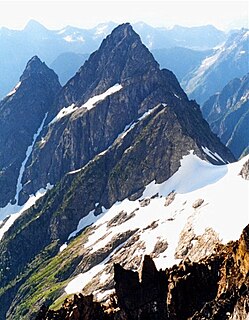
Mount Triumph is a summit in the North Cascades range of Washington state. Located approximately 5.5 miles (8.9 km) west-northwest of the town of Newhalem, it was named by Lage Wernstedt, a surveyor with the U.S. Forest Service. A significant peak in North Cascades National Park, Mount Triumph is one of its "outstanding sights" and is well known among regional climbers for its lack of easy climbing routes to the summit. Despite its moderate elevation, its local relief is dramatic. With the terrain deeply dissected by the valleys of Bacon Creek on the west and Goodell Creek on the east, it rises 1 mile (1.6 km) in less than 2 miles (3.2 km) on the latter side.
The Trapper Trails Council is a former local council of the Boy Scouts of America that served areas in Northern Utah, Southern Idaho and Western Wyoming serving 18 districts. In April 2020, it combined with the former Great Salt Lake and Utah National Parks councils to create the new Crossroads of the West Council.

Image Lake is a tarn in Glacier Peak Wilderness, in the North Cascades of Washington, United States. The lake is surrounded by Plummer Peak to the east, a lookout point to the west, the Miners Creek drainage and Glacier Peak to the south, and Canyon Lake to the north. The course of the popular Miners Ridge Trail skirts the lake. Glacier Peak can be seen from the outlet of the lake, and the peak reflected in the lake is a popular photographic subject.
History of Rocky Mountain National Park began when Paleo-Indians traveled along what is now Trail Ridge Road to hunt and forage for food. Ute and Arapaho people subsequently hunted and camped in the area. In 1820, the Long Expedition, led by Stephen H. Long for whom Longs Peak was named, approached the Rockies via the Platte River. Settlers began arriving in the mid-1800s, displacing the Native Americans who mostly left the area voluntarily by 1860, while others were removed to reservations by 1878.
Trapper Mountain is a 7,530-foot (2,300-metre) summit located in Chelan County of Washington state. It is part of the North Cascades Range. Trapper Mountain is situated southeast of Cascade Pass on the shared border of North Cascades National Park and Glacier Peak Wilderness. The nearest higher peak is Hurry-up Peak, 0.7 miles (1.1 km) to the west. Surface runoff from the mountain drains into Trapper Lake and tributaries of the Stehekin River.


