
A harbor or harbour is a sheltered body of water where ships, boats, and barges can be docked. The term harbor is often used interchangeably with port, which is a man-made facility built for loading and unloading vessels and dropping off and picking up passengers. Ports usually include one or more harbors. Alexandria Port in Egypt is an example of a port with two harbors.
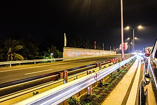
Transport in Sri Lanka is based on its road network, which is centred on the country's commercial capital Colombo. A rail network handles a portion of Sri Lanka's transport needs. There are navigable waterways, harbours and three international airports: in Katunayake, 35 kilometres (22 mi) north of Colombo, in Hambantota, and in Jaffna.
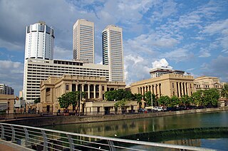
Colombo is the commercial capital and largest city of Sri Lanka by population. According to the Brookings Institution, Colombo metropolitan area has a population of 5.6 million, and 752,993 in the city proper. It is the financial centre of the island and a tourist destination. It is located on the west coast of the island and adjacent to the Greater Colombo area which includes Sri Jayawardenepura Kotte, the legislative capital of Sri Lanka and Dehiwala-Mount Lavinia. Colombo is often referred to as the capital since Sri Jayawardenepura Kotte is itself within the urban/suburban area of Colombo. It is also the administrative capital of the Western Province and the district capital of Colombo District. Colombo is a busy and vibrant city with a mixture of modern life, colonial buildings and monuments.
Trincomalee also known as Gokanna/Gokarna, is the administrative headquarters of the Trincomalee District and major resort port city of Eastern Province, Sri Lanka. Located on the east coast of the island overlooking the Trincomalee Harbour, 237 kilometres (147 mi) north-east of Colombo, 182 kilometres (113 mi) south-east of Jaffna and 111 kilometres (69 mi) miles north of Batticaloa, Trincomalee has been one of the main centres of Sri Lankan Tamil language speaking culture on the island for over two millennia. With a population of 99,135, the city is built on a peninsula of the same name, which divides its inner and outer harbours. People from Trincomalee are known as Trincomalians and the local authority is Trincomalee Urban Council. Trincomalee city is home to the famous Koneswaram temple from where it developed and earned its historic Tamil name Thirukonamalai. The town is home to other historical monuments such as the Bhadrakali Amman Temple, Trincomalee, the Trincomalee Hindu Cultural Hall and, opened in 1897, the Trincomalee Hindu College. Trincomalee is also the site of the Trincomalee railway station and an ancient ferry service to Jaffna and the south side of the harbour at Muttur.

Batticaloa is a major city in the Eastern Province, Sri Lanka, and its former capital. It is the administrative capital of the Batticaloa District. The city is the seat of the Eastern University of Sri Lanka and is a major commercial centre. It is on the east coast, 111 kilometres (69 mi) south of Trincomalee, and is situated on an island. Pasikudah is popular tourist destinations situated 35 km (22 mi) northwest with beaches and flat year-round warm-water shallow-lagoons.

North Western Province is a province of Sri Lanka. The province consists of the districts of Kurunegala and Puttalam. Its capital is Kurunegala, which has a population of 28,571. The province is known mainly for its numerous coconut plantations. Other main towns in this province are Chilaw (24,712) and Puttalam (45,661), which are both small fishing towns. The majority of the population of Wayamba province is of Sinhalese ethnicity. There is also a substantial Sri Lankan Moor minority around Puttalam and Sri Lankan Tamils in Udappu and Munneswaram. Fishing, prawn farming and rubber tree plantations are other prominent industries of the region. The province has an area of 7,888 km², and a population of 2,370,075.

After the outbreak of the Second World War, in the British Crown Colony of Ceylon, the government of Sir Don Baron Jayatilaka assured the British king and his majesty's government of its continued support.

Sandwich Harbour, also known as Sandwich Bay, Sandvishawe, Sandvisbaai and Sandfisch Bai is an area on the Atlantic coast of Namibia that includes a bay in the north and a lagoon at the southern end. Formerly the bay was a moderately-sized commercial port based around whaling and small-scale fishing, but it is now best known for its birdlife in the lagoon to the south of the bay.
The Sri Lanka Railway Department is Sri Lanka's railway owner and primary operator. As part of the Sri Lankan government, it is overseen by the Ministry of Transport. Founded in 1858 as the Ceylon Government Railway, it operates the nation's railways and links Colombo with other population centres and tourist destinations.
China Bay Airport is an air force base and domestic airport in China Bay in eastern Sri Lanka. Located approximately 7 km (4.3 mi) south west of the city of Trincomalee, the airport is also known as Trincomalee Airport and SLAF China Bay.
The Battle of Sampur was a battle fought in 2006 for the town of Sampur.

The Port of Colombo is the largest and busiest port in Sri Lanka. Located in Colombo, on the southwestern shores on the Kelani River, it serves as an important terminal in Asia due to its strategic location in the Indian Ocean. During the 1980s, the port underwent rapid modernization with the installation of Cranes, Gantries and other modern-day terminal requirements.
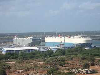
The Hambantota International Port is a deep water port in Hambantota, Sri Lanka. It opened on 18 November 2010 and is operated by Hambantota International Port Group (HIPG), a joint venture between the Sri Lanka Ports Authority and the partially Chinese state-owned China Merchants Port Holdings.

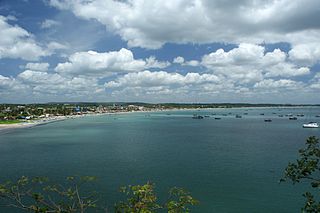
Trincomalee Harbour is a seaport in Trincomalee Bay or Koddiyar Bay, a large natural harbour situated on the northeastern coast of Sri Lanka.
The Trincomalee Garrison is a common name used for collection of military bases of the Sri Lanka Army located in and around the Fort Fredrick and the town of Trincomalee in the Eastern Province. Due to the large natural harbor, it is one of the oldest military garrisons in Sri Lanka and has been occupied by the Portuguese, Dutch, French and the British. Known as Trincomalee Fortress during World War II.
Sri Lanka Navy (SLN) Dockyard is the largest naval base of the Sri Lanka Navy and a major shipyard located in Trincomalee, Sri Lanka. Established by the British as the Royal Naval Dockyard, Trincomalee it was home to the East Indies Station of the Royal Navy during World War II. Since the withdrawal of the Royal Navy, the Royal Ceylon Navy took over dockyard. It became the home base of the RCyN fleet and today it is home to the Eastern Naval Command and the Naval and Maritime Academy of the Sri Lanka Navy.

The Kantale Dam Tamil: கந்தளாய் அணை, romanized: Kantaḷāy Aṇai) is a large embankment dam built in Kantale, Trincomalee District, Sri Lanka, used for irrigation. It is 14,000 ft (4,267 m) long, and over 50 ft (15 m) high. The dam breached on 20 April 1986, killing more than 120 people. It has since been reconstructed. The dam impounds the Per Aru, a small river discharging into the Koddiyar Bay, at Trincomalee Harbour.

The Round Island Lighthouse is an offshore lighthouse on Round Island in Trincomalee Bay, Sri Lanka and is operated and maintained by the Sri Lanka Ports Authority. The lighthouse was erected in 1863, originally it was a red light however in 1864 it was changed to white.
Koddiyar fort was the first fort that was built by Dutch in Ceylon. It was constructed in 1622 and is located on the southern side of Koddiyar Bay.


