Trnovo Forest Plateau

Last updated
Trnovo Forest Plateau
Trnovski gozd 2006.jpg
The Trnovo Forest Plateau seen from Vipavski Križ
Highest point
Elevation 1,247 m (4,091 ft)  OOjs UI icon edit-ltr-progressive.svg
Coordinates 45°57′46″N13°52′20″E / 45.96278°N 13.87222°E / 45.96278; 13.87222 Coordinates: 45°57′46″N13°52′20″E / 45.96278°N 13.87222°E / 45.96278; 13.87222
Geography
Slovenia relief map.png
Red triangle with thick white border.svg
Trnovo Forest Plateau
Location of the Trnovo Forest Plateau
Location Slovenia
Parent range Dinaric Alps

The Trnovo Forest Plateau [1] (Slovene : Trnovski gozd) is a karst plateau that constitutes the extreme northwest end of the Dinaric Alps. [2] The Trnovo Forest Plateau has a karst character, without surface watercourses and broken up by closed valleys, outcroppings, hills, caves, shafts, and smaller karst features: solution pans, rills, karrens, and other features. Significant karst features include ice caves. The vegetation inversion at Big Paradana Ice Cave (Slovene : Velika ledena jama v Paradani) in the eastern part of the plateau, measuring 385 meters (1,263 ft) by 1,550 meters (5,090 ft), is a locus classicus and in the past ice was harvested from it and exported via Gorizia and Trieste to Egypt. [3]

Contents

The Trnovo Forest Plateau has three nature reserves: [4]

Terrain

The influence of tectonic activity is very evident in the area. There are many depressions, solution valleys, small karst poljes, and the remains of former river valleys. During the Pliocene the rivers leveled the tectonic upwelling and filled the valleys. Traces were also left by Pliocene glaciation because glaciers created small cirques on what had been a relatively level surface, as well as ground moraines and terminal moraines. The rivers transported gravel and deposited it in lower areas, filling the depressions.

Rock

The north side of the plateau shows tectonic formation along the Idrija Fault oriented in the Dinaric direction, [5] and the south side shows the results of tectonic thrusting of Mesozoic limestone and dolomite over younger Eocene flysch. Two-thirds of the surface is covered by limestone, one-fourth by dolomite, and the remainder is flysch and loose material.

Mountains

The highest summit is Big Mount Golak (Veliki Golak, 1,495 meters or 4,905 feet). On the northern side, some other panoramic and frequently visited summits are Little Mount Golak (Mali Golak, 1,480 meters or 4,860 feet), Mount Poldanovec (1,298 meters or 4,259 feet), and Pointed Peak (Špičasti vrh 1,128 meters or 3,701 feet), and on the southern side Big Mount Modrasovec (Veliki Modrasovec, 1,355 meters or 4,446 feet), Mount Kucelj (1,237 meters or 4,058 feet), Blue Peak (Sinji vrh, 1,002 meters or 3,287 feet), and Kovk Hill (962 meters or 3,156 feet).

Natural landmarks

Skozno rock window Skozno.jpg
Skozno rock window

Climate

The climate of the Trnovo Forest Plateau is defined by its elevation and orientation. The Trnovo Forest Plateau lies in a continental temperature zone. It receives an average of 1,881 millimeters (74.1 in) of precipitation per year. Differences in the quantity of precipitation differ little on a monthly basis. The greatest precipitation is in November (293 millimeters or 11.5 inches) and the least in February (135 millimeters or 5.3 inches). The majority of winter precipitation is in the form of snow, especially at higher elevations. The bora wind is a typical weather phenomenon, blowing down from the plateau towards the sea with gusts often exceeding 100 kilometers per hour (62 mph). The bora can cause considerable damage in the area, uprooting trees and tearing the roofs off of houses.

Water

Despite the abundant precipitation, karst plateaus have almost no water. The drainage divide is unclear because of the karst surface. The largest spring is that of the Hubelj River near Ajdovščina.

Vegetation

The Trnovo Forest Plateau is covered by mixed beech and fir forest (Abieti-fagetum dinaricum). The highest vegetation is on Little Mount Golak (1,495 meters or 4,905 feet), which is bare at the summit, below which grow dwarf willow ( Salix sp.) and mountain pine (Pinus mugo). Protected flora grows in the rocky crevices, including the Carniolan primrose (Primula carniolica).

The share of forest is 75.5%, but this is increasing because of the afforestation of abandoned farmland. Poor accessibility has resulted in relatively good preservation of the landscape features. The highest peaks are overgrown with mountain pine or grass. Dinaric beech and fir forest grow at elevations between 700 meters (2,300 ft) and 1,200 meters (3,900 ft). At lower elevations this transitions into Dinaric submontane beech forest. There is relatively little shrubland.

Soil

Chromic cambisol and rendzina have developed on Cretaceous and Jurassic limestone and on Triassic dolomite. More acidic soils are found only on limestone with chert. Due to karstification, the depth of regolith is very uneven. The substantial precipitation quickly erodes the soil, and it is also carried away by the bora wind in exposed locations.

Population

The plateau had a population of 4,534 in the 1991 census, [2] and the population density was only 9 per square kilometer (23/sq mi), [2] making the area one of the most sparsely populated in Slovenia. Only the western part is inhabited. The settlements were formed through more recent high-elevation colonization, and the dominant patterns are clustered villages and isolated farms. The age profile of the population is unfavorable.

Economy

In addition to forestry, farming is also an important economic activity. The basic farming activity is animal husbandry, especially raising cattle. The share of the farming population is 14.4%. Tourism is becoming increasingly important: the steep slopes of the plateau attract hikers, and some karst features also attract visitors, especially ice caves and sinkholes because of the vegetation associated with them.

Related Research Articles

Protected areas of Slovenia include one national park, three regional parks, several natural parks, and hundreds of natural monuments and monuments of designed nature. They cover about 12.5% of the Slovenian territory. Under the Wild Birds Directive, 26 sites totalling roughly 25% of the nation's land are "Special Protected Areas"; the Natura 2000 proposal would increase the totals to 260 sites and 32% of national territory.

Ajdovščina Place in Littoral, Slovenia

Ajdovščina is a small town with a population of about 6,700, located in the Vipava Valley, Slovenia. It is the administrative centre of the Municipality of Ajdovščina.

Dinaric Alps Mountain range in the Balkan Peninsula of Southeastern Europe

The Dinaric Alps, also commonly Dinarides, are a mountain range in Southern and Southeastern Europe, separating the continental Balkan Peninsula from the Adriatic Sea. They stretch from Italy in the northwest through Slovenia, Croatia, Bosnia and Herzegovina, Serbia, Montenegro, Kosovo to Albania in the southeast.

Orjen

Orjen is transboundary Dinaric Mediterranean limestone mountain range, located between southernmost Bosnia and Herzegovina and southwestern Montenegro.

Slovene Littoral region

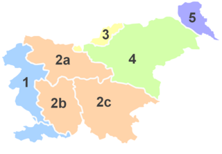
The Slovene Littoral is one of the five traditional regions of Slovenia. Its name recalls the former Austrian Littoral, the Habsburg possessions on the upper Adriatic coast, which the Slovene Littoral was part of.

The Banjšice Plateau is a karst plateau in western Slovenia, in the traditional region of Goriška. It is a dispersely settled area, distinguished by its history and biodiversity. Geographically, it belongs to the Dinaric Alps.

Vipava Valley valley in Slovenia

The Vipava Valley is a valley in the Slovenian Littoral, roughly between the village of Podnanos to the east and the border with Italy to the west. The main towns are Ajdovščina and Vipava.

Otlica Place in Littoral, Slovenia

Otlica is a dispersed settlement in the hills north of Ajdovščina in the Littoral region of Slovenia. It is made up of smaller clusters of the hamlets of Sibirija, Kitajska, Kurja Vas, and Cerkovna, as well as a number of outlying isolated farms. Together with the ridge-top villages of Predmeja, Kovk, and Gozd, it is part of an area locally known as Gora.

Predmeja Place in Littoral, Slovenia

Predmeja is a settlement in the Municipality of Ajdovščina in the Littoral region of Slovenia. It lies on the edge of a karst plateau north of the town of Ajdovščina, overlooking the Vipava Valley. Together with the ridge-top villages of Otlica, Kovk, and Gozd, it is part of an area locally known as Gora.

Snežnik (plateau) mountain in Slovenia

Snežnik is a wide karst limestone plateau with an area of about 85 km2 (33 sq mi) in the Dinaric Alps of Slovenia. It mainly consists of Cretaceous limestone, with Jurassic limestone and a small amount of dolomite at the top. The surface was transformed by ice in the last glacial period. It is generally level, but has numerous dry valleys, sinkholes, about 300 caves and shafts, and cold-air pools with temperatures reaching −32 °C (−26 °F) in the coldest part of year. The surface is mainly stony, covered with patchy and shallow soil, except for the larger depressions. Because the plateau is only 28 km (17 mi) from the Adriatic Sea, it has up to 3,000 millimetres (120 in) of precipitation per year. It is covered by snow in winter. Due to the karst nature of the plateau, there are no surface streams.

Slano Blato Landslide

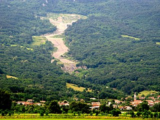
The Slano Blato Landslide, or the Salt Mud Slide, is a periodic landslide in Slovenia that is triggered approximately once a century. Although around 8,000 active landslides are present in Slovenia, the Slano Blato Landslide stands out as one of the most serious in terms of the damage it has caused.

Municipality of Mirna Peč Municipality of Slovenia

The Municipality of Mirna Peč is a municipality in southeast Slovenia, located in the traditional region of Lower Carniola. The seat of the municipality, which was established in 1998, is Mirna Peč. With an estimated population of 2,800, the municipality is included in the Southeast Slovenia Statistical Region.

The Rovte Hills are a group of hills in western Slovenia.

Lož Karst Field

The Lož Karst Field, also known as the Lož Valley, is a karst field in Inner Carniola in southwest Slovenia. It is the smallest karst field in Inner Carniola.

Račna Karst Field karst field near Grosuplje

The Račna Karst Field is a karst field in the northern edge of the Lower Carniolan karst area, south of Grosuplje, Slovenia. It has rich natural and cultural value. Because of its ecological significance, it is anticipated that a nature park will be established there and that it will be included in the Natura 2000 program.

Udin Woods

The Udin Woods is one of the oldest glacial terraces in the Ljubljana Basin. It is a contiguous wooded area clearly delineated from its surroundings. The woods is dominated by Scots pine, and deciduous trees include sessile oak, hornbeam, and beech. It has natural value in terms of its botanical features, terrain, and geomorphology. It was given the status of a protected landscape area in 1985.

Bloke Plateau

The Bloke Plateau is an extensive bowl-like plateau in southwest Slovenia, part of the traditional region of Inner Carniola.

Rute Plateau plateau in Slovenia

The Rute Plateau is a karst limestone plateau in Lower Carniola, Slovenia with an area of about 9 square kilometers (3.5 sq mi).

Karst Living Museum

The Karst Living Museum is a nature trail in Slovenia. Part of the Karst Plateau, the museum is an ecologically-important area with many karst features. It was recognized as Slovenia's best thematic trail in 2017, and the region is a Natura 2000 site.

References

  1. Nered, Janez, & Drago Perko. 2010. Na prelomnici: razvojna vprašanja Občine Idrija. Ljubljana: Založba ZRC, p. 51.
  2. 1 2 3 Perko, Drago, & Milan Orožen Adamič. 1998. Slovenija: pokrajine in ljudje. Ljubljana: Mladinska knjiga, p. 324.
  3. Habič, Peter. 1992. Ledena jama. In: Enciklopedija Slovenije, vol. 6, p. 115. Ljubljana: Mladinska knjiga.
  4. Odlok o spremembah in dopolnitvah prostorskih sestavin dolgoročnega in družbenega plana Občine Ajdovščina za območje Občine Ajdovščina. Official Gazette of the Republic of Slovenia, 30 August 2004. (in Slovene)
  5. Zupan Hajna, Nadja. 2014. Nepopolno raztapljanje karbonatnih kamnin v kraških jamah Slovenije. Ljubljana: ZRC, p. 165.