Trombetas River

Last updated
Trombetas River
Oriximina.jpg
The city of Oriximiná on the banks of the Trombetas near its confluence with the Amazon
Bcamazonica.jpg
Red pog.svg
Location of the mouth of the Trombetas River in the Amazon river watershed
Location
Country Brazil
State Pará
Physical characteristics
Sourceconfluence of Anamu River and Poana River (parts of Anamu sometimes included in the Trombetas on maps, in which case Poana is a right tributary)
  location Pará, Brazil
Mouth Amazon River
  location
Pará, Brazil
  coordinates
1°52′52″S55°38′10″W / 1.88111°S 55.63611°W / -1.88111; -55.63611 Coordinates: 1°52′52″S55°38′10″W / 1.88111°S 55.63611°W / -1.88111; -55.63611
Length760 km (470 mi) [1]
Basin size135,238 km2 (52,216 sq mi) [2]
Discharge 
  average3,437 m3/s (121,400 cu ft/s)
Basin features
Tributaries 
  left Paru de Oeste River
(Erepecuru River/Cuminá River)
  right Mapuera River, Cachorro River
Lake Erepecu (below) runs parallel to, and is connected with, the lower Trombetas River. The unusual white colour is caused by sunglint on the water. Note: The photo is inverted. North is down, west is right Lago Erepecu and Rio Trombetas, Brazil.jpg
Lake Erepecu (below) runs parallel to, and is connected with, the lower Trombetas River. The unusual white colour is caused by sunglint on the water. Note: The photo is inverted. North is down, west is right

The Trombetas is a large river on the northern side of the Amazon River.

Contents

Course

The Trombetas is 750 km (470 mi) long, and is navigable by 500 ton vessels for a stretch of 230 km (140 mi). The Trombetas river gives birth to very many rivers, including the Anamu river. It is formed by the junction of the Poana and Anuma rivers on the border between Brazil and Guyana. Where it meets the Paraná de Sapucuá it takes the name of lower Trombetas, and reaches up to 1.8 km (1.1 mi) in width, with the stream divided by several long and narrow islands. It runs through the municipalities of Oriximiná, Terra Santa, Óbidos and Faro. [3] The river basin has an area of about 133,630 km2 (51,590 sq mi), with an intricate pattern of tributaries including the Poana, Anamu, Turuna, Inhabu, Mapuera and Paru de Oeste. In the Saracá-Taquera National Forest the main streams in the Trombetas basin are the Papagaio, Água Fria, Moura, Jamari, Ajará, Terra Preta and Saracá. [3]

Its confluence with the Amazon is just west of the town of Óbidos, Pará in Brazil. Its sources is in the Guiana highlands, but its long course is frequently interrupted by violent currents, rocky barriers, and rapids. The inferior zone of the river, as far up as the first fall, the Porteira, has but little broken water and is low and swampy; but above the long series of cataracts and rapids the character and aspect of the valley completely change, and the climate is much better. The river is navigable for 135 mi (217 km) above its mouth. [4] The river reaches its highest levels in April and May, since the rainy season usually peaks in April. [3]

Region

The river flows through the Uatuma-Trombetas moist forests ecoregion. [5] The river basin lies partly within the 4,245,819 hectares (10,491,650 acres) Grão-Pará Ecological Station, the largest fully protected tropical forest conservation unit on the planet. [6] South of the ecological station it flows through the 3,172,978 hectares (7,840,600 acres) Trombetas State Forest from north to south. [7]

See also

Related Research Articles

Jaú National Park

The Jaú National Park is a national park located in the state of Amazonas, Brazil. It is one of the largest forest reserve in South America, and part of a World Heritage Site.

Óbidos, Pará Municipio in North, Brazil

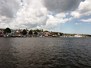
Óbidos is a municipality in Pará, Brazil located at the narrowest and swiftest part of the Amazon River. It's an old town founded in 1697, and located between Santarém and Oriximiná. The town is the seat of the Diocese of Óbidos. The town was named after Óbidos, Portugal.

Rio Trombetas Biological Reserve

Rio Trombetas Biological Reserve is a federally-administered biological reserve in the municipality of Oriximiná, Pará, Brazil. It covers a large area of Amazon biome including rainforest, wetlands and water.

Jari Ecological Station

Jari Ecological Station is an ecological station in Brazil, located in the states of Amapá and Pará, created in 1984.

Iriri River

The Iriri River is a large tributary of the Xingu River in Brazil, in the state of Pará. It is 1,300 km (810 mi) long making it the 116th longest river in the world and the 15th longest in the Amazon basin. The headwaters are the traditional home of the Panará people.

Oriximiná Place in Norte, Brazil

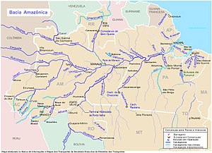
Oriximiná is the westernmost and second-largest municipality in the Brazilian state of Pará. It is also the fourth-largest in the country.

Cuminapanema River

The Cuminapanema River is a river of Pará state in north-central Brazil, a tributary of the Curuá River.

Curuá River (Amazon River tributary)

The Curuá River is a river of Pará state in north-central Brazil.

Maicuru River

The Maicuru River is a river of Pará state in north-central Brazil, a tributary of the Amazon that discharges into that river via the Lago Grande de Monte Alegre.

Paru de Oeste River River in Brazil

The Paru de Oeste River is a tributary of the Trombetas River in Pará in north-central Brazil.

Tapajós National Forest

The Tapajós National Forest is a Brazilian national forest in the state of Pará, Brazil. It supports sustainable exploitation of the natural resources in an area of Amazon rainforest.

Terra Santa Municipality in Northern, Brazil

Terra Santa is a municipality in the state of Pará in the Northern region of Brazil.

Serra do Cachimbo

Serra do Cachimbo is a low mountain range in Brazil, in the southern part of the state of Pará, located mostly in the municipalities of Altamira, Itaituba, Jacareacanga, and Novo Progresso.

Grão-Pará Ecological Station

The Grão-Pará Ecological Station (Portuguese: Estação Ecológica Grão-Pará is a strictly protected ecological station in the state of Pará, Brazil. It managed by the state of Pará. With 42,458 square kilometres of well-preserved Amazon rainforest it is the largest fully protected tropical forest conservation unit in the world.

Jamanxim National Park

The Jamanxim National Park is a national park in the state of Pará, Brazil.

Nascentes da Serra do Cachimbo Biological Reserve Biological reserve in Pará, Brazil

The Nascentes da Serra do Cachimbo Biological Reserve is a biological reserve in the state of Pará, Brazil. The reserve protects an area in the transition between the Cerrado and Amazon biomes, supporting highly diverse flora and fauna including many endemic species. It is accessible via the BR-163 highway, and is among the federal conservation units in the Amazon Legal that has suffered most from deforestation.

Terra do Meio Ecological Station

Terra do Meio Ecological Station is an ecological station (ESEC) in the state of Pará, Brazil.

Mulata National Forest

Mulata National Forest is a national forest in the state of Pará, Brazil.

Saracá-Taquera National Forest

The Saracá-Taquera National Forest is a national forest in the state of Pará, Brazil.

Trombetas State Forest

The Trombetas State Forest is a state forest in the state of Pará, Brazil.

References

  1. Ziesler, R.; Ardizzone, G.D. (1979). "Amazon River System". The Inland waters of Latin America. Food and Agriculture Organization of the United Nations. ISBN   92-5-000780-9. Archived from the original on 8 November 2014.
  2. Para-regionen Archived 2014-12-02 at the Wayback Machine – «Bacias Hidrográficas do Pará».
  3. 1 2 3 Unidade de Conservação ... MMA.
  4. Chisholm 1911.
  5. Sears, Robin, Northern South America: Northeastern Brazil, into southern Guyana and Suriname (NT0173), WWF: World Wildlife Fund, retrieved 2017-03-31
  6. Estação Ecológica Grão-Pará (in Portuguese), Ideflor-bio (Government of Pará), retrieved 2016-05-12
  7. FES do Trombetas (in Portuguese), ISA: Instituto Socioambiental, retrieved 2016-09-07

Sources