Truganina Explosives Reserve

Last updated

Truganina Explosives Reserve
Truganina Explosives Reserve, Altona, Tramway on Explosives Loading Pier.jpg
Tramway on explosives loading pier
Australia Victoria location map.svg
Red pog.svg
Location in Victoria
General information
StatusUnoccupied
TypeFormer government magazine
Address276 Queen Street
Town or city Altona, Victoria, City of Hobsons Bay
CountryAustralia
Coordinates 37°52′39″S144°48′21″E / 37.877400°S 144.805903°E / -37.877400; 144.805903
Construction started1901
Completed1961
Owner Victorian Government
Dimensions
Other dimensions15 hectares (37 acres)

The Truganina Explosives Reserve was a secure storage facility near Altona in the Australian state of Victoria. It was in operation from 1901 to 1962 to store mainly civilian explosives for mining and construction. The camp included several storage sheds and a jetty, which were connected by a narrow-gauge horse-drawn tramway. Like the Dry Creek explosives depot at Port Adelaide, the site is a testimony to history and transportation in Australia.

Contents

Location

Altona's Truganina Explosives Reserve is located approximately 10 miles (16 km) south-west of Melbourne, and 5 miles (8 km) west of Williamstown on the shores of Port Phillip Bay.

History

The Nobel explosives factory (later ICI, then Orica) in Deer Park was set-up in 1873 to produce explosives, especially gelignite and dynamite, for quarries, mines, as well as for road, rail, dam and tunnel construction with the intention to become independent of imports from Britain and South Africa. These explosives were initially stored in specially designed magazines (Jack's Magazine) on the banks of the Maribyrnong River, upstream of Footscray, before being shipped to other parts of Australia or to New Zealand, New Guinea and the Pacific. As the population of Footscray increased, a more remote location for explosives storage was sought. In 1900, Altona had less than fifty inhabitants. The Truganina Explosives Reserve, located less than 4 kilometres (2.5 mi) from Laverton railway station, was finally selected as a convenient location for a new explosives storage site due to its secluded coastal location. [1]

Most of the land had been owned by George Thomas Chirnside, before he agreed in 1896 to swap 225 hectares (560 acres) of his land against 256 hectares (630 acres) of poor quality land of the government of Victoria. The Victorian Government's Victorian Act 1456 is known as the Powder Magazines Act of 1896. A Victorian Act authorized the governor to exchange this land to set-up an explosives reserve and to build and operate a narrow gauge railway line.

Narrow-gauge tramway

Truganina Explosives Reserve Tramway
Horse-drawn explosives train, Altona, Victoria.jpg
Horse-drawn explosives train

Truganina Explosives Reserve Tramway (OpenStreetMap).png
Route of the former tramway [2]
Truganina Explosives Reserve, aerial view, 1960.jpg

Aerial photography, 30 January 1960
Technical
Line length2.7 kilometres (1.7 mi)
Track gauge 600 mm (1 ft 11+58 in)
Operating speed4.5 km/h (2.8 mph)
Route map

km
BSicon exBHFq.svg
BSicon exSTR+r.svg
0
Laverton railway station
BSicon BHFq.svg
BSicon xKRZu.svg
GeelongLavertonMelbourne
BSicon exSTR.svg
Merton Street
BSicon exSTR.svg
Queen Street
BSicon exBHF.svg
Truganina Explosive Reserve
BSicon exWBRUCKE1.svg
Laverton Creek
BSicon exhSTRa.svg
1,618 feet (493 m) long pier [3]
BSicon exhKBHFe.svg
2,7
Dock at end of pier
BSicon KHFNa.svg
Altona Bay
Drawing of tramway bridge, 25 November 1940 Proposed new bridge, Truganina Explosives Reserve (Altona, Victoria, cropped).tif
Drawing of tramway bridge, 25 November 1940

The 610 mm (2 ft) narrow-gauge tramway line began at Laverton railway station and ran along what are now Merton Street and Queen Street through the Truganina Explosives Reserve and then to a jetty at Laverton Creek on Altona Bay. [1] [3] It had eight passing loops parallel to the mainline at the storage facility, as well as sheds and dead-end sidings at Laverton station. [3]

Explosives were delivered by the Victorian Railways from the factory in Deer Park to Laverton railway station. There, the explosives were reloaded by human chain from the railway wagons into the horse-drawn narrow-gauge wagons. The narrow-gauge railway wagons were then hauled by Clydesdale draft horses at a speed of about 4.5 kilometres per hour (3 mph) to the explosives reserve. The narrow-gauge railway line was 2.7 km (133 chains) long. It was in operation until 1936, when rail transport was replaced by road transport. Upon arriving at the reserve, the explosives were stored in the magazines, until they were taken to be loaded onto ships for onward transport. Nine explosives transports were carried out each day with 200 explosives boxes of 50 pounds (22.7 kg) each. [1] Nine horses and 43 wagons were used. [4]

When the explosives had to be shipped to other ports, the explosive boxes were taken by narrow-gauge railway to small boats (lighters) moored at the pier. The specially designed motor-less sailing ships were towed by tugs from the jetty to their moorings at Williamstown. [1] From there lighters took their cargo to larger ships anchored at special explosives buoys in Port Philip Bay.

One of the preserved tramway's carriages on display at the explosives reserve Explosives Tram Carriage.jpg
One of the preserved tramway's carriages on display at the explosives reserve

Magazines

Each magazine had a size of about 9 by 5.5 metres (30 by 18 ft) and could store 20 tons of explosives. The magazines were made of brick, with tile roofs. The roofs were not attached to the walls - they stayed there under their own weight. This was so that, in the event of an explosion, the roof would lift off, minimising damage to the building. The explosives were stacked on air-permeable shelves, so that air could circulate around the boxes at any time. The wooden boxes for explosives were made with brass nails or with only dovetail joints to minimize the possibility of sparking. Each magazine was surrounded on three sides by a large earth wall, with an open side facing away from human activity. These earthworks were designed to protect the workers and their families from explosions. If such an explosion had taken place, the mounds were designed to direct the explosion upwards and outwards and contain the damage. The magazines were built as light as possible to minimize damage caused by flying splinters, with the same design as used in Yatala and Port Adelaide. [5] [6]

Operation

Keeper's Quarters residence, ca 1915 Truganina Explosives Reserve, Keeper's Residence, ca 1915.jpg
Keeper's Quarters residence, ca 1915

The operation of the explosives reserve and the narrow gauge railway was managed by the Trade and Customs Commissioner. The site was officially opened on 1 May 1901, and was enclosed by a 8 feet (2.4 m) high, 7 miles (11 km) long galvanized corrugated iron fence. Careful handling, transportation and storage of the explosive was of paramount importance to ensure safety for employees and residents. Employees who handled the explosives were instructed to wear leather aprons to protect their clothes and to wear canvas overshoes to prevent sparks. Boots with nailed leather soles were considered too dangerous, because of the possibility of the nails causing sparks, which could have resulted in an explosion. [1]

By 1950, the explosives storage in Altona had reached its peak. Sixty-one magazines were in operation. Of these, 52 were used by Nobel Industries, which became later Imperial Chemical Industries of Australia and New Zealand (ICIANZ), and nine by the state government. A total of 36 employees were employed in the explosives reserve. During this time, the population of Altona grew to 4,000. Therefore, the risk of explosives storage in Altona was re-assessed and alternative locations were evaluated. On 11 May 1962, the auxiliary sailing ship Failie became the last vessel to be loaded at the Truganina explosives reserve; all remaining explosives were transported to a newly built explosives warehouse at Point Wilson. The first delivery from Point Wilson took place on 25 May 1962. [1]

After the closure of the Truganina Explosives Reserve in 1962, the Victorian Government sold most of the land, but retained 16 hectares (40 acres) for the State Labour Inspectorate for Destruction of Dangerous Goods. Until closed in 1994, unwanted explosives from throughout Victoria were brought to this site for safe destruction in a specially constructed bunker. In 1976, 0.8 hectares (2 acres) of the 16 hectares were transferred to the State Environmental Protection Agency for use as a vehicle test station, which was closed in June 1999. In June 2000, the Government of Victoria commissioned the Hobsons Bay City Council to administer the former Truganina Explosives Reserve on their behalf as a recreational park. [1]

Accidents and incidents

There were no significant accidents during operation. The stables in Truganina's explosives reserve were burnt down in 1904, presumably by a swagman, however the suspect was not arrested for lack of evidence. [7]

On 9 April 1946 an ammunition lighter had grounded in a storm and was feared to be in danger of blowing up. It was loaded with 300 tons of ammunition, mainly shells. The ammunition could not be unloaded at low tide onto trucks, because of seaweed and the softness of the sand. Thus it was tried to pull the lighter back into the sea by tugs during high tide. [8]

Conservation and protection of landscape, culture and monuments

Plants and animals

The 16 hectares (40 acres) salt marshes and ancient sand dunes have a high conservation value and are the location of rare animal and plant species. [9] Areas of indigenous, exotic and saline vegetation and the hills of the dune system form landscapes with different characteristics that seem timeless. [10] The high corrugated sheet metal fence has protected the site from human entry, leaving it largely undisturbed for more than 100 years, creating a natural, native ecosystem. [11] The reserve is home to three species of birds of local importance, the white-bellied sea eagle, Nankeen night heron and the brown quail. It also houses four bat species including chocolate wattled bat, white-striped free-tailed bat, south-eastern slider, eight other species of mammals and two species of reptiles. [11] [12] The Altona skipper butterfly is a rare and threatened species of butterfly, which has its main habitat at only at two other local sites, where it can find chaffey saw sedge (Ghania filum) to feed from. [12]

Cultural significance

Archaeological research on the property has uncovered many stone artifacts, including ground-edge axes, anvils and hammer-stones, indicating that the land was inhabited by Aboriginal tribes in the coastal area for some 6,500 years. Remnants of indigenous settlement were also found on the property, which together with the artifacts show that the area was used as a storage area. [1] The Department of Treasury and Finance conducted archeological investigations in the former explosives reserve in 1995 and 1996, during which consultants found six artifact sites but no scarred trees, hearths, hearth stones, bone remains or shell scatters. [13]

The area is part of the traditional land of the Yalukit-willam clan, which settled in the coastal areas that stretch from the northern shores of Port Phillip to Wilson's Promontory. Little is known about the lifestyle of the Yalukit-willam clan. The Wurrundjeri Tribe Land Compensation Council and the Council of Cultural Heritage take care of the region's cultural heritage. [1]

Truganini, 1870 B(1871) p187 TASMANIA, THE LAST OF THE ABORIGINALS (LADY).jpg
Truganini, 1870

The name of the explosives reserve is derived from Truganini (1812-1876), who was long considered the last true Aboriginal Tasmanian. [14] She was a daughter of the tribal elder Mananga of the Aborigines of Bruny Island. [15]

Remains of buildings

The Truganina Explosives Reserve is listed under Hermes number 70270 in the Victorian Heritage Database Report. [16] The historical attributes of the site are of Regional Significance. [13] The site is still state owned and has been nominated for listing in the Victorian State Heritage Register. The Keepers Quarters residence is already listed as a local heritage by the Hobson's Bay City Council. [9]

Remains of the tramway

Only little remains of the former tramway have survived. The only visible part of the route can be seen on the south side of the reserve, where it ran in a curve through a gate towards the pier. Some rails with the embossing "WIW Australia" and a crown symbol are embedded in a concrete channel. The crown symbol is probably a trademark of the Commonwealth Steel Company, whose Waratah Iron Works supplied many railways. The route then disappears there underneath the earthworks of a modern footpath. [17]

The railway embankment, which was made of bluestone ballast, became visible during road works on the northeast corner of Queen Street and Merton Street. At this point the right of way of the narrow-gauge tramway line ran with a suitable radius over the property situated at the corner. Another section of the road is preserved near the ford westwards of Merton Street, again only as the earth dam, which turns west from the entrance to Laverton railway station and is partly overbuilt with a modern cycle path. The rails and sleepers are missing in these two sections and other sections of the routes within the reserve, but gravel and few metal artifacts are still visible. The sections within the reserve are either buried or overgrown. [17]

Related Research Articles

<span class="mw-page-title-main">City of Hobsons Bay</span> Local government area in Victoria, Australia

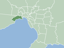
The City of Hobsons Bay is a local government area in Melbourne, Victoria, Australia. It comprises the south-western suburbs between 6 and 20 km from the Melbourne city centre.

<span class="mw-page-title-main">City of Wyndham</span> Local government area in Victoria, Australia

The City of Wyndham is a local government area in Victoria, Australia in the outer south-western suburbs of Melbourne, within the Melbourne Metropolitan Area, between Melbourne and the regional city of Geelong. It has an area of 542 square kilometres (209 sq mi). The city had a population of 292,011 as of the 2021 census. For the year to 2018 the City of Wyndham increased its population by 14,251, the largest number of any LGA in Victoria, as well as being the second most populous and the second fastest growing at a rate of 5.9 per cent.

<span class="mw-page-title-main">Altona, Victoria</span> Suburb of Melbourne, Victoria, Australia

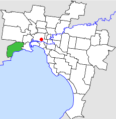
Altona is a suburb in Melbourne, Victoria, Australia, 13 km (8.1 mi) south-west of Melbourne's Central Business District, located within the City of Hobsons Bay local government area. Altona recorded a population of 11,490 at the 2021 census.

<span class="mw-page-title-main">Brooklyn, Victoria</span> Suburb of Melbourne, Victoria, Australia

Brooklyn is a suburb in Melbourne, Victoria, Australia, 10 km (6.2 mi) west of Melbourne's Central Business District, located within the Cities of Brimbank and Hobsons Bay local government areas. Brooklyn recorded a population of 1,979 at the 2021 census.

<span class="mw-page-title-main">Laverton, Victoria</span> Suburb of Melbourne, Victoria, Australia

Laverton established in 1886, is a suburb of Melbourne, Victoria, Australia, 17 km (11 mi) south-west of Melbourne's Central Business District, located within the Cities of Hobsons Bay and Wyndham local government areas. Laverton recorded a population of 4,760 at the 2021 census.

<span class="mw-page-title-main">Newport, Victoria</span> Suburb of Melbourne, Victoria, Australia

Newport is a suburb in Melbourne, Victoria, Australia, 10 km (6.2 mi) south-west of Melbourne's Central Business District, located within the City of Hobsons Bay local government area. Newport recorded a population of 13,658 at the 2021 census.

<span class="mw-page-title-main">Williamstown, Victoria</span> Suburb of Melbourne, Victoria, Australia

Williamstown is a suburb in Melbourne, Victoria, Australia, 11 km (6.8 mi) south-west of Melbourne's Central Business District, located within the City of Hobsons Bay local government area. Williamstown recorded a population of 14,407 at the 2021 census.

<span class="mw-page-title-main">Rail transport in Victoria</span> Overview of rail transport in Victoria, Australia

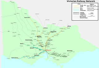
Rail transport in the Australian state of Victoria is provided by a number of railway operators who operate over the government-owned railway lines. The network consists of 2,357 km of Victorian broad gauge lines, and 1,912 km of standard gauge freight and interstate lines; the latter increasing with gauge conversion of the former. Historically, a few experimental 762 mm gauge lines were built, along with various private logging, mining and industrial railways. The rail network radiates from the state capital, Melbourne, with main interstate links to Sydney and to Adelaide, as well as major lines running to regional centres, upgraded as part of the Regional Fast Rail project.

<span class="mw-page-title-main">Altona North</span> Suburb of Melbourne, Victoria, Australia

Altona North is a suburb in Melbourne, Victoria, Australia, 10 km (6.2 mi) south-west of Melbourne's Central Business District, located within the City of Hobsons Bay local government area. Altona North recorded a population of 12,962 at the 2021 census.

<span class="mw-page-title-main">Yarraville, Victoria</span> Suburb of Melbourne, Victoria, Australia

Yarraville is an inner-city suburb in Melbourne, Victoria, Australia, 6 km (3.7 mi) west of Melbourne's Central Business District, located within the City of Maribyrnong local government area. Yarraville recorded a population of 15,636 at the 2021 census.

<span class="mw-page-title-main">Rail transport in South Australia</span>

The first railway in colonial South Australia was a line from the port of Goolwa on the River Murray to an ocean harbour at Port Elliot, which first operated in December 1853, before its completion in May 1854.

<span class="mw-page-title-main">Melbourne and Hobson's Bay Railway Company</span> Railway company in Victoria, Australia

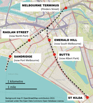
The Melbourne and Hobson's Bay Railway Company was a railway company in Victoria, Australia. The company was incorporated on 20 January 1853 to build the line from Melbourne to the port of Sandridge, now Port Melbourne.

<span class="mw-page-title-main">National Railway Museum, Port Adelaide</span> Railway museum

The National Railway Museum, Port Adelaide, South Australia is the largest railway museum in Australia. More than 100 major exhibits, mainly from the South Australian Railways (SAR) and Commonwealth Railways and their successor, Australian National, are displayed at its 3.5 hectares site. A very large archival collection of photographs of those railways and records created by them is also managed by the museum. The museum is operated with a large number of volunteers.

<span class="mw-page-title-main">Point Wilson, Victoria</span> Place in Victoria, Australia

Point Wilson is a locality located on the northern shores of Corio Bay, Victoria. it is approximately 60 kilometres by road from Melbourne, and 25 kilometres by road from Geelong.

<span class="mw-page-title-main">City of Altona</span> Local government area in Victoria, Australia

The City of Altona was a local government area about 13 kilometres (8 mi) west of Melbourne, the state capital of Victoria, Australia. The city covered an area of 40.18 square kilometres (15.51 sq mi), and existed from 1957 until 1994.

<span class="mw-page-title-main">Newington Armory</span> Historic site in New South Wales, Australia

Newington Armory is a heritage-listed former Royal Australian Navy armament depot, now used for tourism purposes, at Holker Street, Sydney Olympic Park, Cumberland Council, New South Wales, Australia. It was built from 1897 initially by the New South Wales Military Forces then by the Australian Army and later by the Royal Australian Navy. It is also known as Millennium Heritage Parklands Precinct, RAN Armament Depot Newington, Royal Australian Navy Armament Depot (RANAD), Newington Nature Reserve and Sydney Olympic Games site. The property is owned by the Sydney Olympic Park Authority. It was added to the New South Wales State Heritage Register on 14 January 2011.

<span class="mw-page-title-main">Cherry Lake (Victoria)</span>

Cherry Lake is part of historical coastal wetlands in Altona, a suburb of Melbourne, Victoria, Australia. The wetlands were converted to a lake with construction of retaining walls, levees and flow channels. The lake and surrounding reserve is an important wildlife habitat and popular recreational destination.

The Truganina Coastal Parklands are located 15 km west of Melbourne CBD, on the shores of Port Phillip Bay, stretching from Altona to Altona Meadows and adjacent to the Cheetham Wetlands and the Point Cook Coastal Park. They were formed through the 'recycling' of more than 300 hectares of parks and former industrial land and are now the largest cluster of parks on Port Phillip Bay, interlinked by cycling and walking trails and featuring a surprisingly high diversity and abundance of landscapes, natural environment and recreational areas, including beachside recreation, picnic & barbecue facilities, grassfields and wildlife conservation areas. The wetlands form part of the Cheetham and Altona Important Bird Area.

<span class="mw-page-title-main">Dry Creek explosives depot</span> Former explosives storage facility near Port Adelaide

The Dry Creek explosives depot was a secure storage facility at Dry Creek, near Port Adelaide, from 1904 to 1995, serving the construction, mining and quarrying industries of South Australia and the mines of Broken Hill in New South Wales.

<span class="mw-page-title-main">Chattenden and Lodge Hill Military Camps</span>

Chattenden and Lodge Hill Military Camps were British Army training camps in Chattenden and Hoo St Werburgh in Kent. They were built as ordnance depots and functioned as such through to the second half of the twentieth century.

References

  1. 1 2 3 4 5 6 7 8 9 Altona Laverton Historical Society: Truganina Explosives Reserve - Establishing an Explosives Reserve. Retrieved on 25 August 2018.
  2. Laverton Explosive Tram on Facebook.
  3. 1 2 3 Railpage: Truganina Explosives Reserve and Tramway (Historical). Retrieved on 25 August 2018.
  4. Truganina Explosives Reserve Brochure. Retrieved on 25 August 2018
  5. Bridget Jolly: High And Dry By The Mangroves? South Australia's Dry Creek Explosives Magazines. Erstmals präsentiert bei der Fifth Australian Urban History Planning History Conference, University of South Australia, 13.–15. April 2000 and published in the Conference Proceedings, issued by Christine Garnaut and Stephen Hamnett, University of South Australia, Adelaide 2000, S. 222–232.
  6. Bridget Jolly: A Significant Site: the Former Dry Creek Explosives Reserve in: Journal of the Historical Society of South Australia, No. 29, 2001, ISSN   0312-9640, S. 70–84.
  7. Report of the Chief Inspector of Explosives to the Honorable the Chief Secretary, on the Working of the Explosives Act During the Year 1904. Presented to both Houses of Parlia1fent Pursuant to the Provisions of Section 35 of Act No. 1090. 31 December 1904. Retrieved on 25 August 2018. S. 3 von 8.
  8. Grounded Munition Ship Scares Altona. In: The Argus 10 April 1946. Reproduced by Greg Milne: This Month in 1946. In: Around Altona. Issue 82, April 2015, page 12.
  9. 1 2 Truganina Explosives Reserve Preservation Society: Truganina Explosives Reserve Keepers Quarters Restoration Project.
  10. "Truganina Explosives Magazine Complex (former) and trees". Victorian Heritage Database. Retrieved 27 May 2009.
  11. 1 2 "Conservation Reserves". Hobsons Bay City Council. Archived from the original on 29 October 2007. Retrieved 22 March 2009.
  12. 1 2 Hobsons Bay City Council: Appendix 4 - Truganina Explosives Reserve Master Plan. 14 April 2015. Retrieved on 27 August 2018.
  13. 1 2 Altona Explosives Reserve (Former). In: National Trust Database. File L10000.
  14. E. C. Thompson: Truganina. The History of School No. 192, based on the research of George F. Green, head teacher 1932-1935. Educational Magazine, Vol 17, No 10.
  15. www.womenaustralia.info. Retrieved on 18 June 2009.
  16. Altona Explosives Reserve (Former). In: Victorian Heritage Database Report. Hermes Number 70270. Retrieved on 26 August 2018.
  17. 1 2 Truganina Explosives Reserve Tramway. In: Victorian Heritage Database Report. Hermes Number 22240. Retrieved on 26 August 2018.