
The Coral Sea Islands Territory is an external territory of Australia which comprises a group of small and mostly uninhabited tropical islands and reefs in the Coral Sea, north-east of Queensland, Australia. The only inhabited island is Willis Island. The territory covers 780,000 km2 (301,160 sq mi), most of which is ocean, extending east and south from the outer edge of the Great Barrier Reef and includes Heralds Beacon Island, Osprey Reef, the Willis Group and fifteen other reef/island groups. Cato Island is the highest point in the Territory.

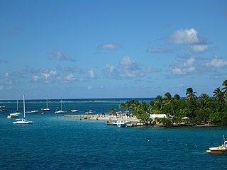
The United States Virgin Islands are a group of several dozen islands and cays located in the Caribbean, about 1,100 miles (1,770 km) southeast of Florida, 600 miles (966 km) north of Venezuela, 40 miles (64 km) east of Puerto Rico, and immediately west and south of the British Virgin Islands.

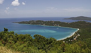
Trunk Bay is a body of water and a beach on St. John in the United States Virgin Islands. Trunk Bay is part of the Virgin Islands National Park. Trunk Bay is named for the Leatherback turtle, which is endemic to the USVI and are locally known as trunks. The beach area is divided into two halves, the main Trunk Bay beach and swim area and Burgesman Cove which is located on the west end of Trunk Bay near Jumby Bay. Its amenities include a snack bar, showers and restrooms, a lifeguard, and an underwater trail for snorkeling its coral reef. Trunk Bay has consistently been voted one of the top beaches in the world.

Great Guana Cay is an islet in The Bahamas. It is a long, narrow islet, 7 miles (11 km) long. It is in the centre of the Abaco Islands and is near Gumelemi Cay. It is about 8 miles from Marsh Harbour. Approximately 150 people live on the island, mostly along the five and a half mile long stretch of beach.

Cinnamon Bay is a body of water and a beach on St. John island, within Virgin Islands National Park, in the United States Virgin Islands.
Bellamy Cay is an island in the British Virgin Islands, located entirely within Trellis Bay on Beef Island. Formerly called Blanco Islet, this island is named after its most famous resident, "Black Sam" Bellamy, the "prince of pirates".

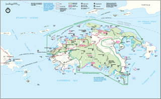
The following is an alphabetical list of articles related to the territory of the United States Virgin Islands.

Carvel Rock is an uninhabited islet of the US Virgin Islands in the Caribbean, less than 2 acres in size. It is visited by boats as a scuba diving site, but its sheer cliffs and lack of a beach mean that landing would be practically impossible.

The fauna of the United States Virgin Islands consists of 144 species of birds, 22 species of mammals, 302 species of fish and 7 species of amphibians. The wildlife of the U.S.V.I. includes numerous endemic species of tropical birds, fish, and land reptiles as well as sea mammals. The only endemic land mammals are six species of native bats: the greater bulldog bat, Antillean fruit-eating bat, red fruit bat, Brazilian free-tailed bat, velvety free-tailed bat and the Jamaican fruit bat. Some of the nonnative land mammals roaming the islands are the white-tailed deer, small Asian mongoose, goats, feral donkeys, rats, mice, sheep, hogs, dogs and cats.
Protestant Cay is a four-acre triangular islet in the Christiansted Harbor, 200 yards north of Christiansted. The island is home to a resort, the Hotel on the Cay, which is home to a protected sand beach, small shop and beach bar. It also has the closest beach to Downtown Christiansted. With one of the ferries, which run from 7 a.m. to 12 a.m., every ten minutes, it will only take about two minutes to get there. The ride is free of charge after 4 p.m., and for guests of the Hotel on the Cay. To get on the ferry, passengers have to stand near the boardwalk in front of the King Christian Hotel and wave to the boat captain on duty.

Steven Cay is a small scrub-covered and rocky Caribbean island, about 28 feet high and situated 0.5 miles west of Cruz Bay on Saint John in the United States Virgin Islands. It is a popular destination for snorkelers and scuba divers,.
Turtledove Cay is a rocky 3.78 acre islet, located 100 yards north of Saba Island in the United States Virgin Islands. Its elevation is 50 feet and the islet is covered with tall grass. It is joined with Saba Island by a reef, which is bare at times of extremely low water. Turtledove Cay are all designated wildlife reserves by the territorial U.S.V.I. government. Turtledove Cay is home to large quantities of native avifauna, including large colonies of noddies and other seabirds.

Whistling Cay is a 19-acre (7.7 ha) islet, situated 300 yards (270 m) west of Mary Point on Saint John in the United States Virgin Islands. It is covered with trees and high cliffs in the north, where it reaches a 130-foot (40 m) elevation. A gravel beach is located on the southeast side of the island. It is separated from Saint John by the Fungi Passage, which has a depth of 21 feet (6.4 m).
Kalkun Cay is a rocky, steep and narrow islet, located in the middle of the Savana Passage in the United States Virgin Islands. It is one mile northeast of Savana Island and one mile west of West Point on the island of Saint Thomas. Kalkun Cay is 73 feet high and covered with underbrush and grass. It is an important habitat of native seabirds.
Ramgoat Cay is an islet in the United States Virgin Islands, located 310 yards northeast of Henley Cay and 1300 feet north of Hawksnest Point on the island of Saint John. It is 30 feet high and located within the Virgin Islands National Park.
Henley Cay, previously known as Women's Cay, is an 11-acre tropical islet in the United States Virgin Islands. The cay is 300 yards in diameter and the largest and southernmost of the Durloe Cays in the Virgin Islands National Park. Henley Cay is situated 2,200 feet northwest of Turtle Bay on the island of Saint John, separated from the island by the Durloe Channel. The cay is 70 feet high and has a pier on its southern side, although it is uninhabited. The island is known as a snorkeling and kayaking destination, but is also visited for its white sandy beaches. Companies offer guided kayak tours from Cruz Bay, Honeymoon Bay, and Caneel Bay to Henley- and Lovango Cays.
Cinnamon Cay is a cay in the United States Virgin Islands, situated approximately 0.7 miles east of Trunk Cay in the Cinnamon Bay, and 100 yards from the shore at Cinnamon Bay Beach on Saint John island. It has a height of 32 feet. The islet is uninhabited, but regularly visited by scuba-divers, snorkelers and kayakers. Cinnamon Bay Watersports offers kayaks and snorkeling equipment for travelers to the cay. Cinnamon Cay is mostly covered with grass and cactus, and is located within the Virgin Islands National Park.

East End is an administrative subdistrict of the island of St. Thomas in the United States Virgin Islands. The largest community is Red Hook, while smaller communities include Benner, Nazareth, Nadir, Frydendal, and Smith Bay. The subdistrict includes the offshore islands of Great Saint James, Little Saint James, Bovoni Cay, Patricia Cay, Cas Cay, Rotto Cay, Thatch Cay, Shark Island, and Dog Island.
Northside with its population of 10,049 as of the 2010 United States Census is the second-most populous administrative census subdistrict (CSD) on Saint Thomas, only less populated than the Charlotte Amalie subregion with the islands’ territorial capital of more than 18,000 people. Northside is sometimes called Nordside in Virgin Islands Creole, which is the Danish translation for north side. Northside is home to communities such as Neltjeberg, Zambee, Resolution, Ensomned, Barrett, Solberg, Lerkenlund, Misgen, Mafolie, Louisenhoj, Estate Thomas, Mandal, Enighed, Canaan, and Peterborg. By area, the Northside subdistrict is the largest administrative census sub-district on the Saint Thomas island.


