
The University Centre in Svalbard is a Norwegian state-owned limited company that is involved in research and provides some higher education in Arctic studies. The company is wholly owned by the Ministry of Education and Research, and the universities of Oslo, Bergen, Tromsø, NTNU and NMBU appoint the board of directors. It is led by a director appointed by the board for a four-year term. The centre is the world’s northernmost research and higher education institution, in Longyearbyen at 78° N latitude. The courses offered fall into five main science disciplines: Arctic biology, Arctic geology, Arctic geophysics, Arctic technology and Arctic safety.

Adventdalen is a 30-kilometre (19 mi) valley on the island Spitsbergen in Svalbard, Norway. The river that runs through the valley, Adventdalselva, flows into Adventfjorden just outside Longyearbyen. Adventfjorden is an arm of Isfjorden.

Oscar II Land is the land area between Isfjorden and Kongsfjorden on Spitsbergen, Svalbard. The 30 km (19 mi) long glacier Sveabreen divides Oscar II Land from James I Land.
Dickson Land is a land area between Isfjorden and Wijdefjorden at Spitsbergen, Svalbard. It forms a peninsula between the Isfjorden branches Billefjorden and Dicksonfjorden. Dickson Land is named after Oscar Dickson.

Platåberget is a mountain in Nordenskiöld Land on the island of Spitsbergen in Svalbard, Norway. It is 464 meters (1,522 ft) tall and has a distinct plateau shape, for which it is named. It is bordered to the west by the Bjørndalen valley and the Fuglefjella bird cliffs, to the east by the Blomsterdalen mountain and to the north by Hotellneset and Adventfjorden. The mountain is a few kilometers from Longyearbyen and is next to Svalbard Airport, Longyear. It is the site of Svalbard Satellite Station and Svalbard Global Seed Vault.
Carlsfjella is a mountain ridge in Oscar II Land at Spitsbergen, Svalbard. The ridge has a length of 14 kilometers, is located between St. Jonsfjorden and Løvenskioldfonna, and includes Valentinryggen, Patronen, Knausen and Haraldfjellet. The ridge is named after land owner Carl Otto Løvenskiold.
Johnsenberget is a mountain at Kongsøya of the Kong Karls Land, Svalbard. It has a height of 235 m.a.s.l., and is located at the eastern part of the island, between Koppelvatna and Rundisflya, north of Andréebukta. The mountain is named after captain Nils Johnsen, who climbed the mountain in 1872.
Rundisflya is a plain at the eastern part of Kongsøya in Kong Karls Land, Svalbard. It is located west of the mountain Johnsenberget, and generally has a height of 50 m.a.s.l. or higher. Rundisflya is named after the glacier Rundisen, which covers part of the plain.
Dunérfjellet is a mountain on Svenskøya in Kong Karls Land, Svalbard. It has a height of 230 m.a.s.l., and is located at the northern part of the island, separated from Mohnhøgda by the mountain pass Vindsalen. The mountain is named after Swedish astronomer Nils Christoffer Dunér. Dunérfjellet has a relatively flat plateau, with steep hills down to the lowlands of Svenskøya.
Mohnhøgda is a mountain on Svenskøya in Kong Karls Land, Svalbard. It has a height of 285 m.a.s.l., and is located at the northern part of the island, separated from Dunérfjellet by the mountain pass Vindsalen. The mountain is named after Norwegian meteorologist and astronomer Henrik Mohn.
Hambergfjellet is a mountain at the island of Bjørnøya of the Svalbard archipelago, Norway. It has a height of 440 m.a.s.l. The mountain is named after Swedish geographer and Arctic explorer Axel Hamberg. The mountain has given name to the geological unit Hambergfjellet Formation, which complete section exposures from the cliffs of Hambergfjellet and Alfredfjellet.

Hayesbreen is a glacier in Sabine Land at Spitsbergen, Svalbard. It is named after American politician and Arctic explorer Isaac Israel Hayes. The glacier has a length of about eighteen kilometers, and debouches into the bay of Mohnbukta. Surrounding mountains are Aagaardfjellet to the north, Jebensfjellet to the south, and Panofskyfjellet where Hayesbreen joins the glacier of Königsbergbreen.
Arbobreen is a glacier in Dickson Land at Spitsbergen, Svalbard. It is named after Norwegian botanist Ove Arbo Høeg. The glacier is situated north of the mountain of Lagfjellet, and has a length of about 3.5 kilometers. The ridge of Snøplogen separates Arbobreen from Hodsbreen.
De Geerdalen is a valley in Nordenskiöld Land at Spitsbergen, Svalbard. It is named after Swedish geologist and Arctic explorer Gerard De Geer. The mountain pass of Kreklingpasset divides De Geerdalen from Helvetiadalen. The river of De Geerelva flows through the valley, and debouches into Sassenfjorden at Elveneset.
Botneheia is a mountain in Nordenskiöld Land at Spitsbergen, Svalbard. It has a height of 522 m.a.s.l., and is located south of Sassenfjorden, east of the valley of De Geerdalen.
Sauriedalen is a valley in Dickson Land at Spitsbergen, Svalbard. It has a length of about sixteen kilometers, extending from Njordfjellet and Gyntflya to Tschermakfjellet. The valley is named from fossil Triassic reptiles (sauria), found in the nearby Saurieberget.
Kapp Toscana is a headland at the southern side of Van Keulenfjorden in Wedel Jarlsberg Land at Spitsbergen, Svalbard. It is named after an Austrian family. West of the headland is the bay of Bourbonhamna, extending from Kapp Toscana to Kapp Madrid. East of the headland is the bay of Ingebrigtsenbukta, extending from Kapp Toscana to Ålesundneset.
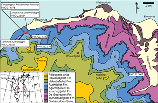
The Tschermakfjellet Formation is a geological formation in Svalbard, Norway, a subunit of the Kapp Toscana Group. The formation dates to the Late Triassic.
Kongressfjellet is a mountain in Dickson Land at Spitsbergen, Svalbard. It has a height of 605 m.a.s.l., and is located between the valleys of Idodalen (north) and Sauriedalen (east), and the mountain of Tschermakfjellet (south).
Idodalen is a valley in Dickson Land at Spitsbergen, Svalbard. It has a length of about 5.5 kilometers, and is located between the mountains of Kongressfjellet and Heimenfjellet. The valley is named after the constructed language of Ido. The river of Idoelva flows through the valley.
