Tschiertschen-Praden

Last updated
Tschiertschen-Praden
Tschiertschen Ansicht.jpg
Tschiertschen village
CHE Tschiertschen-Praden COA.svg
Location of Tschiertschen-Praden
Tschiertschen-Praden
Switzerland adm location map.svg
Red pog.svg
Tschiertschen-Praden
Reliefkarte Graubunden blank.png
Red pog.svg
Tschiertschen-Praden
Coordinates: 46°49′N9°36′E / 46.817°N 9.600°E / 46.817; 9.600
Country Switzerland
Canton Graubünden
District Plessur
Government
   Executive Gemeinderat
   Mayor Gemeindepräsident
Area
[1]
  Total27.74 km2 (10.71 sq mi)
Elevation
1,350 m (4,430 ft)
Population
 (31 December 2018) [2]
  Total305
  Density11/km2 (28/sq mi)
Time zone UTC+01:00 (Central European Time)
  Summer (DST) UTC+02:00 (Central European Summer Time)
Postal code(s)
7063, 7063
SFOS number 3932
Localities Praden, Tschiertschen
Surrounded by Calfreisen, Castiel, Churwalden, Maladers, Arosa, Lüen, Molinis, Parpan, Vaz/Obervaz
Website www.tschiertschen-praden.ch
SFSO statistics

Tschiertschen-Praden is a municipality in the Plessur Region in the Grisons, Switzerland. It was formed on 1 January 2009 through the merger of Praden and Tschiertschen. [3]

Contents

Geography

Tschiertschen has a combined area, as of 2006, of 27.8 km2 (10.7 sq mi). [4]

Before 2017, the municipality was located in the Churwalden sub-district of the Plessur district on the mountain slopes above the left side of the Schanfigger valley. It consists of the haufendorf village (an irregular, unplanned and quite closely packed village, built around a central square) of Tschiertschen at an elevation of 1,351 m (4,432 ft) and the linear villages of Inner- and Usserpraden at an elevation of 1,100 m (3,600 ft) and 1,250 m (4,100 ft) respectively.

Demographics

Tschiertschen-Praden has a population (as of 31 December 2020) of 300. [5]

The combined historical population is given in the following table: [6] [7]

yearpopulation
1803280
1850268
1900270
1950272
2000326

Weather

Tschiertschen has an average of 123.9 days of rain per year and on average receives 1,095 mm (43.1 in) of precipitation. The wettest month is August during which time Tschiertschen receives an average of 140 mm (5.5 in) of precipitation. During this month there is precipitation for an average of 12.7 days. The month with the most days of precipitation is June, with an average of 13.1, but with only 128 mm (5.0 in) of precipitation. The driest month of the year is February with an average of 61 mm (2.4 in) of precipitation over 12.7 days. [8]

Related Research Articles

<span class="mw-page-title-main">Zernez</span> Municipality in Graubünden, Switzerland

Zernez is a village and a municipality in the Engiadina Bassa/Val Müstair Region in the Swiss canton of Graubünden. On 1 January 2015 the former municipalities of Lavin and Susch merged into the municipality of Zernez.

<span class="mw-page-title-main">Val Müstair</span> Municipality in Graubünden, Switzerland

Val Müstair is a municipality in the Engiadina Bassa/Val Müstair Region in the Swiss canton of Graubünden. It was formed on 1 January 2009 through the merger of Tschierv, Fuldera, Lü, Valchava, Santa Maria Val Müstair and Müstair.

<span class="mw-page-title-main">Arosa</span> Municipality in Graubünden, Switzerland

Arosa is a town and a municipality in the Plessur Region in the canton of Graubünden in Switzerland. It is both a summer and a winter tourist resort.

<span class="mw-page-title-main">Vals, Switzerland</span> Municipality in Graubünden, Switzerland

Vals is a village and a municipality in the Surselva Region in the canton of Graubünden in Switzerland. On 1 January 2015 the former municipality of St. Martin merged into the municipality of Vals.
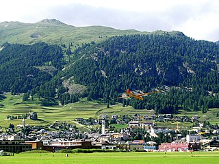
<span class="mw-page-title-main">Tamins</span> Municipality in Graubünden, Switzerland

Tamins is a village and a municipality in the Imboden Region in the Swiss canton of Graubünden.

<span class="mw-page-title-main">Avers</span> Municipality in Grisons, Switzerland

Avers is a high Alpine valley region and a municipality in the Viamala Region in the Swiss canton of Graubünden. It includes Juf, the highest-altitude year-round settlement in Europe.

<span class="mw-page-title-main">Andeer</span> Municipality in Graubünden, Switzerland

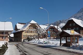
Andeer is a municipality in the Viamala Region in the Swiss canton of Graubünden. In 2009 Clugin and Pignia merged into Andeer.

Tschiertschen is a village in the municipality of Tschiertschen-Praden in the district of Plessur in the canton of Graubünden in Switzerland.

Praden is a village in the municipality of Tschiertschen-Praden in the district of Plessur in the canton of Graubünden in Switzerland.

<span class="mw-page-title-main">Hinterrhein, Switzerland</span> Municipality in Graubünden, Switzerland

Hinterrhein is a village and a former municipality in the Viamala Region in the Swiss canton of Graubünden. The village is located near the start of the river Hinterrhein/Rein Posteriur, one of the two initial tributaries of the Rhine. On 1 January 2019 the former municipalities of Hinterrhein, Nufenen and Splügen merged to form the new municipality of Rheinwald.

<span class="mw-page-title-main">Bregaglia</span> Municipality in Graubünden, Switzerland

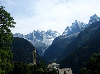
Bregaglia is a municipality in the Maloja Region in the canton of Grisons in Switzerland. It was formed by the 2010 merger of the municipalities of Bondo, Castasegna, Soglio, Stampa and Vicosoprano, all located in the Val Bregaglia.

<span class="mw-page-title-main">Ferrera</span> Municipality in Graubünden, Switzerland

Ferrera is a municipality in the Viamala Region in the Grisons, Switzerland. It was formed on 1 January 2008 through the merger of Innerferrera and Ausserferrera. Geographically, it covers the entire Ferrera valley.

<span class="mw-page-title-main">Calanca</span> Municipality in Graubünden, Switzerland

Calanca is a municipality in the Moesa Region in the Swiss canton of Graubünden. On 1 January 2015 the former municipalities of Arvigo, Braggio, Cauco and Selma merged to form the new municipality of Calanca.

<span class="mw-page-title-main">Wildhaus-Alt St. Johann</span> Municipality in St. Gallen, Switzerland

Wildhaus-Alt St. Johann is a municipality in the Wahlkreis (constituency) of Toggenburg in the canton of St. Gallen in Switzerland. It was formed on 1 January 2010 through the merger of Alt St. Johann and Wildhaus.

<span class="mw-page-title-main">Escholzmatt-Marbach</span> Municipality in Lucerne, Switzerland

Escholzmatt-Marbach is a municipality in the district of Entlebuch in the canton of Lucerne in Switzerland. On 1 January 2013 the former municipalities of Escholzmatt and Marbach merged to form the new municipality of Escholzmatt-Marbach.

<span class="mw-page-title-main">Buchegg</span> Municipality in Solothurn, Switzerland

Buchegg is a municipality in the district of Bucheggberg, in the canton of Solothurn, Switzerland. On 1 January 2014 the former municipalities of Tscheppach, Brügglen, Aetingen, Aetigkofen, Bibern (SO), Gossliwil, Hessigkofen, Mühledorf (SO), Küttigkofen and Kyburg-Buchegg merged into the new municipality of Buchegg. On 1 January 2024 the former municipality of Lüterswil-Gächliwil merged into the municipality of Buchegg.

<span class="mw-page-title-main">Ilanz/Glion</span> Municipality in Graubünden, Switzerland

Ilanz/Glion is a municipality in the Surselva Region in the Swiss canton of Graubünden. On 1 January 2014 the former municipalities of Castrisch, Ilanz, Ladir, Luven, Pitasch, Riein, Ruschein, Schnaus, Sevgein, Duvin, Pigniu, Rueun, and Siat merged into the new municipality of Ilanz/Glion.

<span class="mw-page-title-main">Albula/Alvra</span> Municipality in Graubünden, Switzerland

Albula/Alvra is a municipality in the Albula Region in the canton of Graubünden in Switzerland. On 1 January 2015, the former municipalities of Alvaschein, Mon, Stierva, Tiefencastel, Alvaneu, Brienz/Brinzauls, and Surava merged to form the new municipality of Albula/Alvra.

<span class="mw-page-title-main">Bergün Filisur</span> Municipality in Graubünden, Switzerland

Bergün Filisur is a municipality in the Albula Region in the canton of Graubünden in Switzerland. On 1 January 2018 the former municipalities of Bergün/Bravuogn and Filisur merged to form the new municipality of Bergün Filisur.

<span class="mw-page-title-main">Rheinwald, Switzerland</span> Municipality in Graubünden, Switzerland

Rheinwald is a municipality in the Viamala Region in the Swiss canton of Graubünden. On 1 January 2019 the former municipalities of Hinterrhein, Nufenen and Splügen merged to form the new municipality of Rheinwald.

References

  1. "Arealstatistik Standard - Gemeinden nach 4 Hauptbereichen". Federal Statistical Office. Retrieved 13 January 2019.
  2. "Ständige Wohnbevölkerung nach Staatsangehörigkeitskategorie Geschlecht und Gemeinde; Provisorische Jahresergebnisse; 2018". Federal Statistical Office. 9 April 2019. Retrieved 11 April 2019.
  3. Amtliches Gemeindeverzeichnis der Schweiz published by the Swiss Federal Statistical Office (in German) accessed 23 September 2009
  4. Swiss Federal Statistical Office accessed 27-Oct-2009
  5. "Ständige und nichtständige Wohnbevölkerung nach institutionellen Gliederungen, Geburtsort und Staatsangehörigkeit". bfs.admin.ch (in German). Swiss Federal Statistical Office - STAT-TAB. 31 December 2020. Retrieved 21 September 2021.
  6. Praden in German , French and Italian in the online Historical Dictionary of Switzerland .
  7. Tschiertschen in German , French and Italian in the online Historical Dictionary of Switzerland .
  8. "Temperature and Precipitation Average Values-Table, 1961-1990" (in German, French, and Italian). Federal Office of Meteorology and Climatology - MeteoSwiss. Archived from the original on 27 June 2009. Retrieved 8 May 2009., the weather station elevation is 1375 meters above sea level.