| Tsjaka | |
|---|---|
| Settlement | |
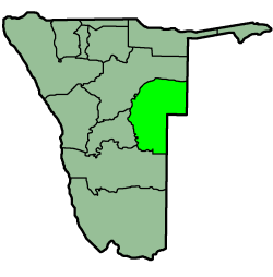
| Region | Omaheke Region |
| Constituency | Kalahari Constituency |
| Time zone | South African Standard Time (UTC+1) |
Tsjaka is a settlement in Omaheke Region in eastern Namibia. Located approximately 50 kilometres (31 mi) south of the regional capital Gobabis, it is inhabited primarily by the Tswana and San people. The village can only be reached by a gravel road via the Highway C22.

Namibia, officially the Republic of Namibia, is a country in southern Africa. Its western border is the Atlantic Ocean; it shares land borders with Zambia and Angola to the north, Botswana to the east and South Africa to the south and east. Although it does not border Zimbabwe, less than 200 metres of the Zambezi River separates the two countries. Namibia gained independence from South Africa on 21 March 1990, following the Namibian War of Independence. Its capital and largest city is Windhoek, and it is a member state of the United Nations (UN), the Southern African Development Community (SADC), the African Union (AU), and the Commonwealth of Nations.

Gobabis is a city in eastern Namibia. It is the regional capital of the Omaheke Region, and the district capital of the Gobabis electoral constituency. Gobabis is situated 200 km (120 mi) down the B6 motorway from Windhoek to Botswana. The town is 113 km (70 mi) from the Buitepos border post with Botswana, and serves as an important link to South Africa on the tarred Trans-Kalahari Highway. Gobabis is in the heart of the cattle farming area. In fact Gobabis is so proud of its cattle farming that a statue of a large Brahman bull with the inscription "Cattle Country" greets visitors to the town. Gobabis also has its own local Airport.

The Tswana are a Bantu-speaking ethnic group who are native to Southern Africa. The Tswana language belongs to the Bantu group. Ethnic Tswana made up approximately 85% of the population of Botswana in 2011.
Tsjaka belongs to the Kalahari Constituency of Omaheke Region. The settlement features a centre of the Komeho Development Agency, a non-governmental organisation that also provides accommodation facilities for visitors, several farms in the radius of 50 kilometres [1] and a primary school. The Mphe Thuto Primary School serves 440 learners from the settlement and the neighbouring farms and location. [2] The main economic activity is subsistence farming with goats and sheep.

Kalahari Constituency is an electoral constituency in Omaheke Region, Namibia. It has 9,234 inhabitants, the constituency office has been inaugurated in 2009 and is located at the Ben-Hur settlement. The constituency forms part of the border between Namibia and Botswana.

The Mphe Thuto Primary School is located in Tsjaka, a small village in Eastern Namibia, close to Botswana. Almost 440 pupils from grade one to seven attend the Mphe Thuto Primary School.