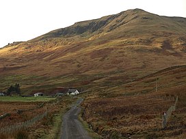
Ben Vorlich is a mountain located in the southern part of the Highlands of Scotland. Due to its prominence when seen from the lower ground of the Central Belt, Ben Vorlich is one of the most commonly seen of Munros, Scotland's peaks of 3000ft height or above. It lies in an area of land bounded to the north by Loch Earn, and to the west by Loch Lubnaig. The town of Callander lies to the south.

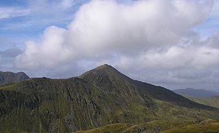
Ben Vorlich is a Scottish mountain situated between the northernmost section of Loch Lomond and Loch Sloy. It is one of the Arrochar Alps, though it lies separate from the other peaks in the range, as indicated by the large topographic prominence. It is the highest point of the historic county of Dunbartonshire.

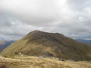
Ben Chonȝie, also known as Ben-y Hone, is a Scottish mountain situated eleven kilometres northwest of Crieff. It stands at 931 m (3054 ft) and is therefore listed as a Munro. It is the highest point of a large area of moorland and rounded hills between Loch Earn and Loch Tay, and with a broad, flat summit and relatively few distinguishing features, it is often regarded as one of Scotland's least interesting Munros. It is most often climbed from Invergeldie (Comrie) to the southwest; however it can also be climbed from the southeast by way of Glen Turret. The latter is longer but presents walkers with a more interesting and scenic ascent, having an array of buttresses and cliffs which can be tackled by those who feel brave, or passed by on either side. Mountain hares can be seen around the plateau area if walkers are quiet and observant. There are also many other animals on the approaches to the Ben, including Buzzards, other birds of prey, and frogs and newts in the pools alongside the landrover track that runs up the eastern aspect of the loch. Deer may be seen on the slopes to the north of the Ben.
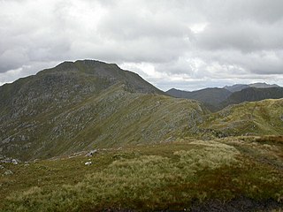
Sgùrr a' Mhaoraich is a Scottish mountain located to the north of Loch Quoich in the north western highlands. It has a height of 1027 m (3369 ft) and is classed as a Munro. Viewed from Kinloch Hourn to the west, or from the north, it shows large, steep, rocky flanks with a complex series of ridges and corries, but like its neighbours such as Gleouraich, its southern side is gentler and grassier.
Sgiath Chùil is a mountain situated in the southern highlands of Scotland. It stands within Loch Lomond and the Trossachs National Park, on its northern border. It is about 11 kilometres (6.8 mi) west of Killin.

Sgurr Mhurlagain is a mountain in the Northwest Highlands, Scotland, west of the village of Spean Bridge in Lochaber.

Meall an t-Seallaidh is a mountain in the Southern Highlands of Scotland. It is located in the Loch Lomond and The Trossachs National Park, west of Loch Earn.

Beinn a' Chlachair is a mountain in the Grampian Mountains of Scotland. It lies south of Loch Laggan, near the remote hamlet of Kinloch Laggan.

Doune Hill is a peak in the foothills of the Grampian Mountains of Scotland. It is located near the village of Luss in Argyll and Bute, west of Loch Lomond.
Sgurr Mor is a mountain in the Northwest Highlands of Scotland, on the southern side of Loch Quoich in Lochaber.

Geal Charn is a mountain in the Grampian Mountains of Scotland. It is situated in the Highlands, on the southern shore of Loch Laggan.

Beinn Ruadh is a mountain of Argyll and Bute in Scotland. Part of the Grampian Mountains, it lies between Loch Eck and Loch Long in Argyll Forest Park.

Beinn Bhreac is a mountain in Argyll and Bute, Scotland. It is part of the Luss Hills, a southern subrange of the Grampian Mountains.

Beinn a' Chochuill is a mountain in the Grampian Mountains of Scotland, located east of Loch Etive in Argyll and Bute.
Toll Creagach is a mountain in the Northwest Highlands of Scotland. It lies between Glen Affric in the south and Loch Mullardoch in Inverness-shire.
Garbh Chioch Mhor is a mountain in the Northwest Highlands of Scotland. It lies in the Lochaber region, between Loch Nevis and Loch Quoich.
Beinn a' Mhanaich is a hill in the southern Grampian Mountains of Scotland. It is located in Argyll and Bute, in the southern Luss Hills north of the town of Helensburgh.

Creag Ghuanach is a mountain in the Grampian Mountains of Scotland. It is located in Lochaber, at the southern head of Loch Treig.

Aonach Beag is a 1,116-metre (3,661 ft) mountain in the Highlands of Scotland in the remote area between Loch Ericht and Loch Laggan located about 4 kilometres (2.5 mi) northwest of Ben Alder. Its prominence is 99 metres (325 ft) with its parent peak, Geal-Charn, about 1 kilometre (0.62 mi) to the east. In Gaelic, Aonach Beag means "little ridge" despite it being a Munro. It should not be confused with the better-known Munro near Ben Nevis, also called Aonach Beag, about 30 kilometres (19 mi) to the west.

The Rhinns of Kells are a range of hills in the Galloway Hills range, part of the Southern Uplands of Scotland. The most easterly of three parallel ridges, they are neighboured to the west by the Range of the Awful Hand and the Dungeon Hills. The eastern portion of the Minnigaff Hills range lies immediately southwest of the range. In total, these four ranges are part of the Galloway Forest Park. The ridge is located entirely within Dumfries and Galloway, with the base of the western flanks being a northwestern boundary of the county.