
The Tuolumne River flows for 149 miles (240 km) through Central California, from the high Sierra Nevada to join the San Joaquin River in the Central Valley. Originating at over 8,000 feet (2,400 m) above sea level in Yosemite National Park, the Tuolumne drains a rugged watershed of 1,958 square miles (5,070 km2), carving a series of canyons through the western slope of the Sierra. While the upper Tuolumne is a fast-flowing mountain stream, the lower river crosses a broad, fertile and extensively cultivated alluvial plain. Like most other central California rivers, the Tuolumne is dammed multiple times for irrigation and the generation of hydroelectricity.

Parker Dam is a concrete arch-gravity dam that crosses the Colorado River 155 miles (249 km) downstream of Hoover Dam. Built between 1934 and 1938 by the Bureau of Reclamation, it is 320 feet (98 m) high, 235 feet (72 m) of which are below the riverbed (the deep excavation was necessary in order to reach the bedrock on which the foundation of the dam was built), making it the deepest dam in the world. The portion of the dam above the foundation stands 85 feet (25.9 m) tall, making it the only dam in the world that stands more underground than above ground. The dam's primary functions are to create a reservoir, and to generate hydroelectric power. The reservoir behind the dam is called Lake Havasu and can store 647,000 acre⋅ft (798,000,000 m3; 2.11×10¹¹ US gal; 1.76×10¹¹ imp gal). The dam straddles the Arizona-California state border at the narrows the river passes through between the Whipple Mountains in San Bernardino County, California and the Buckskin Mountains in La Paz County, Arizona.

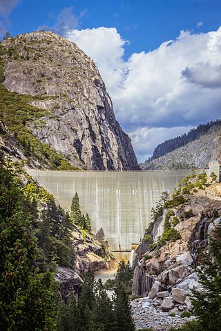
New Melones Dam is an earth and rock filled embankment dam on the Stanislaus River, about 5 miles (8.0 km) west of Jamestown, California, United States, on the border of Calaveras County and Tuolumne County. The water impounded by the 625-foot-tall (191 m) dam forms New Melones Lake, California's fourth-largest reservoir, in the foothills of the Sierra Nevada east of the San Joaquin Valley. The dam serves mainly for irrigation water supply, and also provides hydropower generation, flood control, and recreation benefits.

The Stanislaus River is a tributary of the San Joaquin River in north-central California in the United States. The main stem of the river is 96 miles (154 km) long, and measured to its furthest headwaters it is about 150 miles (240 km) long. Originating as three forks in the high Sierra Nevada, the river flows generally southwest through the agricultural San Joaquin Valley to join the San Joaquin south of Manteca, draining parts of five California counties. The Stanislaus is known for its swift rapids and scenic canyons in the upper reaches, and is heavily used for irrigation, hydroelectricity and domestic water supply.

The Klamath Project is a water-management project developed by the United States Bureau of Reclamation to supply farmers with irrigation water and farmland in the Klamath Basin. The project also supplies water to the Tule Lake National Wildlife Refuge, and the Lower Klamath National Wildlife Refuge. The project was one of the first to be developed by the Reclamation Service, which later became the Bureau of Reclamation.

The New Waddell Dam is an embankment dam on the Agua Fria River in Maricopa County, Arizona, 35 miles (56 km) northwest of Phoenix. It serves as part of the Central Arizona Project (CAP) while also providing water for the Maricopa Water District. The dam creates Lake Pleasant with water from the Agua Fria and also the CAP aqueduct. In addition, it affords flood protection, hydroelectric power production and recreational opportunities. Construction on the dam began in 1985 and ended in 1994. Its reservoir submerged the Old Waddell Dam which was completed in 1927 after decades of planning.
New Spicer Meadow Reservoir is a reservoir in the Sierra Nevada, within the Stanislaus National Forest in eastern Tuolumne County, California.

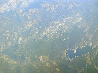
New Melones Lake is a reservoir on the Stanislaus River in the central Sierra Nevada foothills, within Calaveras County and Tuolumne County, California.
The South San Joaquin Irrigation District (SSJID), located in Southern San Joaquin County, California, is a non-profit utility that provides irrigation water and domestic water in the Central Valley of California along with hydroelectric power.

New Don Pedro Dam, often known simply as Don Pedro Dam, is an earthen embankment dam across the Tuolumne River, about 2 miles (3.2 km) northeast of La Grange, in Tuolumne County, California. The dam was completed in 1971, after four years of construction, to replace the 1924 concrete-arch Don Pedro Dam.
Bara Dam is a proposed small, low-head, earth core rockfill, hydroelectric dam with a capacity of 5.8 megawatts, located across Bara River at the confluence of Mastura River in Tirah Valley, Khyber Agency, FATA, Pakistan. It is part of a wider plan that consists in remodeling the Bara River, to promote agriculture.

Beardsley Dam is a dam on the Middle Fork Stanislaus River in Tuolumne County, California. The site is surrounded by the Stanislaus National Forest.
Donnells Dam is a concrete arch dam located on the Middle Fork of the Stanislaus River in Tuolumne County, California. The water impounded by the 291-foot (89 m) high dam forms Donnell Lake in Stanislaus National Forest. The dam and reservoir are co-owned by the Oakdale Irrigation District and South San Joaquin Irrigation District, and the dam is one of three in the Tri-Dam Project. The other two dams in the project are Beardsley Dam and Tulloch Dam.
Garzan Dam is an embankment dam on the Garzan River 9 km (5.6 mi) northeast of Kozluk in Batman Province, Turkey. It is part of the Southeastern Anatolia Project and has a primary purpose of hydroelectric power generation and irrigation. Surveys for the dam were completed in 2008, construction began in 2009 and the dam began to impound its reservoir in October 2012. The power plant has an installed capacity of 49 MW. The irrigation works remain under construction and are expected to irrigate an area of 40,000 ha when complete. The dam was awarded to FERNAS Energy Electricity Generation Co. Inc. in 2011 under a build–operate–transfer basis.

The Middle Fork Stanislaus River is a 45.7-mile (73.5 km) tributary of the Stanislaus River in the central Sierra Nevada and Stanislaus National Forest of eastern California.

Relief Dam is a rockfill dam on Summit Creek, a tributary of the Middle Fork Stanislaus River, in Tuolumne County, California. The dam is part of the Spring Gap-Stanislaus Hydroelectric Project, and is owned and operated by Pacific Gas and Electric (PG&E).
The Deduru Oya Dam is an embankment dam built across the Deduru River in Kurunegala District of Sri Lanka. Built in 2014, the primary purpose of the dam is to retain approximately a billion cubic metres of water for irrigation purposes, which would otherwise flow out to sea. Site studies of the dam began in 2006 and construction started in 2008. It was ceremonially completed in 2014, with the presence of the then President Mahinda Rajapaksa.
Lake Tulloch, located in Copperopolis, California, is one of the few lakes in California that has private shoreline houses. At roughly 504 feet (154 m) in elevation the lake covers 1,260 acres (510 ha). Lake Tulloch provides water needs to downstream users and hydroelectricity to users throughout the state.

The North Fork Tuolumne River is a 35.7-mile (57.5 km) long river in the central Sierra Nevada of Tuolumne County, California and is a major tributary of the Tuolumne River. It originates above the Dodge Ridge Ski Area about 2 miles (3.2 km) east of Pinecrest, in the Stanislaus National Forest. From there it flows generally southwest, past Long Barn, Twaine Harte, Soulsbyville and Tuolumne. Below Long Barn the river flows through a narrow canyon on its way to join the Tuolumne River, at the head of Lake Don Pedro Reservoir, about 5 miles (8.0 km) north of Groveland.
The Chaskaman Dam is one of the important dams of Maharashtra and is built on the Bhima River at Rajgurunagar in Pune district. It is located across river Bhima in Krishna basin near Village Bibi in Khed Taluka, Pune. The main purpose of this dam was to improve irrigation and supply of electricity to the nearby villages. It is the second Hydel Greenfield power project in the country that is capable of captive power as well. The power will be utilized through the state power board. The project was completed during 2008-09.
