Tum Airport

Last updated
Tum Airport

Maji Airport
Summary
Airport typePublic
OperatorEthiopian Civil Aviation Authority
Serves Maji, Ethiopia
Location Tum
Elevation  AMSL 4,650 ft / 1,417 m
Coordinates 6°15′35″N35°31′10″E / 6.25972°N 35.51944°E / 6.25972; 35.51944
Map
Ethiopia adm location map.svg
Airplane silhouette.svg
TUJ
Location of the airport in Ethiopia
Runways
Direction LengthSurface
mft
12/309303,051Grass
Source: Google Maps [1] SkyVector [2]

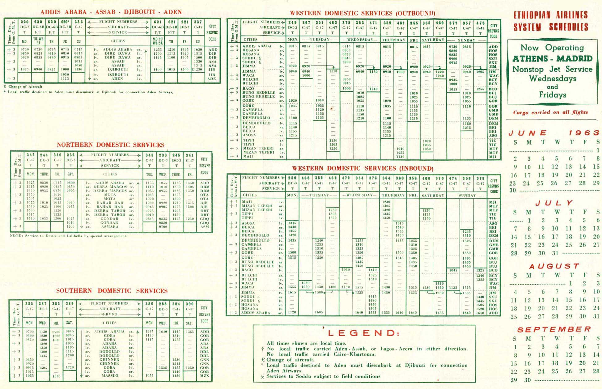
Tum Airport( IATA : TUJ, ICAO : HAMJ) is a public airport in southwestern Ethiopia. Located at an elevation of 4,650 feet above sea level, the airport serves the villages of Tum and Maji, the administrative center of the Maji District. The airport was formerly served by Ethiopian Airlines. [3]

Contents

Maji sits atop a ridge on the Boma Plateau, more than 3,000 feet (910 m) above the airport at Tum. The plateau runs west through southeast of the airport. The runway slopes uphill to the southeast. [4]

See also

Related Research Articles

<span class="mw-page-title-main">Hartsfield–Jackson Atlanta International Airport</span> International airport in Atlanta, Georgia, United States

Hartsfield–Jackson Atlanta International Airport, also known as Atlanta Hartsfield–Jackson International Airport, Hartsfield–Jackson International Airport, Atlanta Airport, Hartsfield–Jackson, and formerly as the Atlanta Municipal Airport, is the primary international airport serving Atlanta, Georgia, United States. The airport is located 10 mi (16 km) south of the Downtown Atlanta district. It is named after former Atlanta mayors William B. Hartsfield and Maynard Jackson. ATL covers 4,700 acres (19 km2) of land and has five parallel runways. Since 1998, Hartsfield-Jackson has been the world's busiest airport by passenger traffic. In 2022, the airport had over 93.6 million passengers, the most of any airport in the world.

<span class="mw-page-title-main">Hilton Head Airport</span> Airport

Hilton Head Airport is on Hilton Head Island, in Beaufort County, South Carolina, United States. Also known as Hilton Head Island Airport, it is owned by Beaufort County.

<span class="mw-page-title-main">Arusha Airport</span> Airport located in Arusha Region, Tanzania

Arusha Airport is a domestic airport located in Olasiti ward of the city of Arusha, the capital of the Arusha Region of Tanzania. The airport is currently undergoing an expansion, which includes a new apron and terminal building.

<span class="mw-page-title-main">Diego Jiménez Torres Airport</span> Airport owned by the Puerto Rico Ports Authority

Diego Jiménez Torres Airport was a public use airport owned by the Puerto Rico Ports Authority and located 1 mile (1.6 km) south of Fajardo, a city in Puerto Rico. It is also known as Fajardo Airport.

Humacao Airport is a public use airport owned by the Puerto Rico Ports Authority and located 1.6 miles (2.6 km) southeast of Humacao, a city in Puerto Rico.

Mbandaka Airport is an airport serving the Congo River port of Mbandaka, capital city of the Équateur District in the Democratic Republic of the Congo. The runway is on the southeast side of the city.

<span class="mw-page-title-main">Matari Airport</span> Airport in Democratic Republic of the Congo

Matari Airport is an airport serving Isiro, a city in Haut-Uélé Province, Democratic Republic of the Congo. The airport is 6 kilometres (3.7 mi) northwest of the city.

Muanda Airport or Moanda Airport is an airport serving Muanda, an Atlantic coastal city in the Democratic Republic of the Congo.

Robe Airport is a public airport in the town of Bale Robe in Oromia Region of Ethiopia. It also serves the nearby town of Goba.

<span class="mw-page-title-main">Alula Aba Nega Airport</span> Airport in Mekelle, Tigray Region, Ethiopia

Alula Aba Nega Airport, also known as Mekelle Airport, is a public airport serving Mekelle, the capital city of the Tigray Region in northern Ethiopia. The airport is located 10 km southeast of the city.

Shire Airport, also known as Shire Inda Selassie Airport or Indaselassie Airport, is a public airport serving Shire, a city in the Tigray National Regional State, in northern Ethiopia. The airport lies at an elevation of 6,207 feet (1,892 m) above mean sea level. It is located just south of the city.

<span class="mw-page-title-main">Enrique Adolfo Jiménez Airport</span> Airport in Colón, Panama

Enrique Adolfo Jiménez Airport is an international airport located in Colón, Panama, offering scheduled airline flights to Panama City, and to other destinations. The airport is just east of Colon's harbor and cargo handling facilities.

Moyale Airport, also referred to as Moyale Lower Airport, is an airport located in the town of Moyale, Marsabit County, in the northern part of the Republic of Kenya, at the international border with Ethiopia. Its location is approximately 590 kilometres (370 mi), by air, northeast of Nairobi International Airport, the country's largest civilian airport. The geographic coordinates of this airport are:3° 27' 54.00"N, 39° 6' 18.00"E.

Mandera Airport is an airport in Mandera, Kenya.

<span class="mw-page-title-main">Ustupu-Ogobsucum Airport</span> Airport

Ustupu-Ogobsucum Airport is an airport serving the island town of Ustupo in the Guna Yala comarca of Panama. It handles domestic flights and general aviation.

Dolo Airport is an airport serving Dolo in Ethiopia.

Dodola Airport is an airstrip serving the city of Dodola in the Oromia Region of Ethiopia. The runway is 15 kilometres (9.3 mi) west of the city.

Cartí Airport is an airport serving the Cartí islands in the San Blas Archipelago of Panama. The airport is on the mainland, approximately 2.7 kilometres (1.7 mi) southwest of Cartí Sugtupu island.

<span class="mw-page-title-main">Panamá Pacífico International Airport</span> Airport in Panama

Panamá Pacífico International Airport is a commercial airport in Panama. It is located on the site of the former Howard Air Force Base, a United States Air Force base that was within the Panama Canal Zone. Panama City can be reached by crossing the nearby Bridge of the Americas.

Los Pozos Airport is an airport serving the city of San Gil in the Santander Department of Colombia.

References

  1. Google Maps - Tum
  2. "Maji Airport". SkyVector. Retrieved 6 December 2018.
  3. "Ethiopian Airlines 1963 schedule". WebCite. Archived from the original on 22 December 2015. Retrieved 6 December 2018.
  4. "Tum Airport". OpenStreetMap. Retrieved 6 December 2018.