
The Brigach is the shorter of two streams that jointly form the river Danube in Baden-Württemberg, Germany. The Brigach has its source at 925 m (3,035 ft) above sea level within St. Georgen in the Black Forest. The Brigach crosses the city Villingen-Schwenningen. 40.4 km (25.1 mi) from the source, the Brigach joins the Breg in Donaueschingen to form the Danube River.
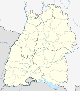
Schwarzwald-Baar is a Landkreis (district) in the south of Baden-Württemberg, Germany. Neighboring districts are Ortenaukreis, Rottweil, Tuttlingen, Constance, the Swiss canton of Schaffhausen, and the districts Waldshut, Breisgau-Hochschwarzwald and Emmendingen.

Villingen-Schwenningen is a town in the Schwarzwald-Baar district in southern Baden-Württemberg, Germany. It has 85,838 inhabitants.

Weissach im Tal is a municipality (Gemeinde) in the Rems-Murr-Kreis district of Baden-Württemberg, Germany. It belongs to the metropolitan region of Stuttgart. On 31 December 2005 it had a population of 7,205. Weissach im Tal is twinned with Marly in France and Lommatzsch in Saxony. Mayor is Ian Schölzel. Weissach im Tal is one of a few municipalities in Rems-Murr district, which has no areas. In Aichholzhof is the biggest school complex, called "Bildungszentrum Weissach im Tal, with all three types of schools after the elementary school around a radius of about 30 km (~16,6 nm).
Mühlhausen is a city in Thuringia, Germany.

Balingen is a town in Baden-Württemberg, Germany, capital of the district of Zollernalbkreis. It is located near the Swabian Jura, approx. 35 km to the south of Tübingen, 35 km northeast of Villingen-Schwenningen, and 70 km south southwest of Stuttgart.

Niefern-Öschelbronn is a municipality in the Enz district, in Baden-Württemberg, Germany. It is situated on the river Enz, 6 km east of Pforzheim.

Geisingen is a town in the district of Tuttlingen, in Baden-Württemberg, Germany. It is situated on the Danube, 13 km southwest of Tuttlingen, and 21 km southeast of Villingen-Schwenningen.
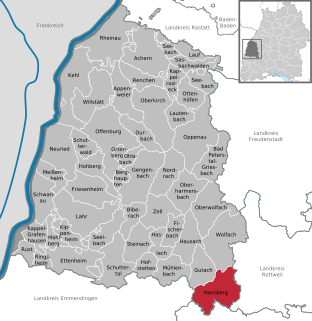
Hornberg is a town in the Ortenaukreis, in western Baden-Württemberg, Germany. It is situated in the Black Forest, 35 km southeast of Offenburg, and 25 km northwest of Villingen-Schwenningen.
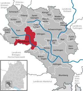
Vöhrenbach is a town in the district of Schwarzwald-Baar, in Baden-Württemberg, Germany. It is situated on the river Breg, 12 km west of Villingen-Schwenningen.

Deißlingen is a municipality of the district of Rottweil of Baden-Württemberg, Germany.

Wört is a municipality and town in the district of Ostalbkreis in Baden-Württemberg in Germany.
Dauchingen is a municipality in the district of Schwarzwald-Baar in Baden-Württemberg, Germany.

Königsfeld im Schwarzwald is a town in the district of Schwarzwald-Baar in Baden-Württemberg in Germany. It is the northernmost town of the district Schwarzwald Baar. Königsfeld has six boroughs. Founded in 1807, it is a centre of the Moravian Church. Until after the Second World War, most of the town's inhabitants continued to be Moravians and the Vorsteher of the Congregation also served as de facto Mayor of the town. After the war, great numbers of refugees from former eastern provinces of Germany settled in the town. Königsfeld is on several major bus lines, the next train stations are in St. Georgen and Villingen-Schwenningen. Regional bus lines connect Königsfeld to these towns. Until 1981 it was served by the train station Peterzell-Königsfeld, 5 km outside Königsfeld. Königsfeld is the seat of several boarding schools and a classical Gymnasium/High School/Public School and a School for Home Economics, all operated by the Moravian Church. Humanitarian Albert Schweizer maintained a home in Königsfeld because his wife could not live in Lambaréné due to her health. His home in Königsfeld is now a museum. There is also a small museum dealing with the history of the town.

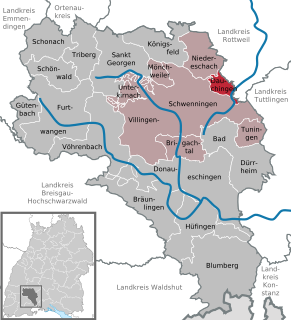
Niedereschach is a town, with 6000 inhabitants, in the district of Schwarzwald-Baar in Baden-Württemberg in Germany.
The Baar is a plateau that lies 600 to 900 metres above sea level in southwest Germany. It is bordered by the southeastern edge of the Black Forest to the west, the southwestern part of the Swabian Alb known as the Heuberg to the east, and the Randen mountain to the south.
Villingen (Schwarzwald) station is one of two stations in Villingen-Schwenningen in the German state of Baden-Württemberg. The other is Schwenningen (Neckar). In addition, there are five more halts (Haltepunkte). The station is located east of the old town of Villingen beyond the Brigach. It is located at 704 metres above sea level on the Black Forest Railway and it is the terminus of the Rottweil–Villingen railway.
The Rottweil–Villingen railway is a single-track, non-electrified, railway on the eastern edge of the Black Forest in the German state of Baden-Württemberg. It runs partly in the upper Neckar valley and connects Rottweil on the Stuttgart–Hattingen railway with Villingen-Schwenningen on the Black Forest Railway. It is served by timetable line 742, on the Rottweil–Bräunlingen/–Trossingen Stadt route (Alemannenbahn).
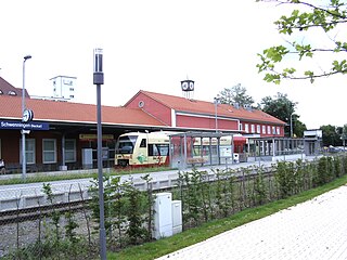
Schwenningen (Neckar) station is one of two stations in Villingen-Schwenningen in the German state of Baden-Württemberg. The other is Villingen (Schwarzwald). Schwenningen owes its connection to the railway to Johannes Bürk, who had demanded a route through Schwenningen to promote the local watch industry, which included his own factory. The original plans involved a route through Niedereschach. The station is located at the Neckar, south of central Schwenningen. It is located at 695 metres above sea level on the Rottweil–Villingen railway. Originally the station was 540 metres long and up to 56 metres wide. The complex included a station building and a goods shed.

Trossingen station is a station that serves Trossingen, but is located in the municipality of Deißlingen in the German state of Baden-Württemberg. Its name in German, Trossingen Bahnhof, rather than Bahnhof Trossingen, indicates that it serves Trossingen, but it is not in it. The Trossingen Railway branches off the Rottweil–Villingen railway off here and connects the city to the railway network. The station is at 644 metres above sea level between Dauchingen, Deißlingen, Trossingen and Villingen-Schwenningen near the intersection of autobahn 81 and federal highway 27.


