Carbon County is a county located in the U.S. state of Pennsylvania. As of the 2010 census, the population was 65,249. Its county seat is Jim Thorpe, founded in 1818 as Mauch Chunk, a company town of the Lehigh Coal & Navigation Company (LC&N) as it built a wagon road nine miles to their coal mine at today's Summit Hill, and constructed the Lehigh Canal navigations.

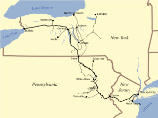
The Lehigh Valley Railroad was one of a number of railroads built in the northeastern United States primarily to haul anthracite coal. The railroad was authorized on April 21, 1846, for freight and transportation of passengers, goods, wares, merchandise and minerals in the U.S. state of Pennsylvania and the railroad was incorporated/established on September 20, 1847, as the Delaware, Lehigh, Schuylkill and Susquehanna Railroad Company. On January 7, 1853, the railroad's name was changed to Lehigh Valley Railroad. It was sometimes known as the Route of the Black Diamond, named after the anthracite it transported. At the time, anthracite was transported by boat down the Lehigh River; the railroad was meant to be faster transportation. The railroad ended operations in 1976 and merged into Conrail along with several northeastern railroads that same year.
The Warren Railroad was a railroad in Warren County, New Jersey, that served as part of the Delaware, Lackawanna and Western Railroad's mainline from 1856 to 1911.

The Lehigh Canal or the Lehigh Navigation Canal is a navigable canal, beginning at the mouth of Nesquehoning Creek on the Lehigh River in Eastern Pennsylvania. It was built in two sections over a span of twenty years, beginning in 1818. The lower section spanned the distance between Easton, Pennsylvania and the town of Mauch Chunk, present-day Jim Thorpe, Pennsylvania. In Easton the canal met the Delaware and Morris Canals, with which goods could be brought further up the east coast. At its height, the Lehigh Canal was 72 miles (116 km) long.

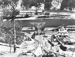
The Mauch Chunk and Summit Railroad was a coal-hauling railroad in the mountains of Pennsylvania that operated between 1828 and 1932. It was the first operational US railway of any substantial length to carry paying passengers.

This article is about the company that operated from 1822-1967. For the corporation launched in 1988, see Lehigh Coal and Navigation Company.

Ashley Planes was a historic freight cable railroad situated along three separately powered inclined plane sections located between Ashley, Pennsylvania at the foot, and via the Solomon cutting the yard in Mountain Top over 1,000 feet (300 m) above and initially built between 1837-38 by Lehigh Coal & Navigation Company's subsidiary Lehigh and Susquehanna Railroad (LH&S). One result of the 1837 updates of omnibus transportation bills called the Main Line of Public Works (1824), the legislation was undertaken with an eye to enhance and better connect eastern settlement's business interests with newer mid-western territories rapidly undergoing population explosions in the Pre-Civil War era. But those manufactories needed a source of heat, and the Northern Pennsylvania Coal Region was barely connected to eastern markets except by pack mule, or only through long and arduous routes down the Susquehanna then overland to Philadelphia.

Allentown was a train station in Allentown, Pennsylvania. It was constructed by the Central Railroad of New Jersey (CNJ) and Reading Railroad in 1888–1889. The station closed in 1967 with the cessation of CNJ passenger service. The station was located one block east of the Lehigh Valley Railroad's Allentown station.
East Mauch Chunk, organized as a Pennsylvania township when a part of 19th century Northampton County, Pennsylvania, was originally settled in the 1820s as a cross river bedroom community from both vanished Lausanne Landing and the explosively growing Mauch Chunk which it served as an upscale bedroom community, where company managers and officers were known to build homes, along with the housing built in what is known as upper Mauch Chunk. The community became a township in [TBDL: date and County] and was later organized [TBDL: 1850s? Cite History of Carbon County] as a formerly independent borough in Carbon County, Pennsylvania.

The Nesquehoning Valley Railroad Company, herein called the Nesquehoning Valley Railroad (NVRR), is now a fallen flag standard-gauge, steam era shortline railroad built as a coal road to ship the Anthracite mined in the Southeastern Coal Region on either side of the Little Schuylkill River tributary Panther Creek and the history making coal towns of the Panther Creek Valley down the Lehigh River transportation corridor to the Eastern seaboard.

The Lehigh Line is a railroad line in central New Jersey and northeastern Pennsylvania. It is owned and operated by the Norfolk Southern Railway. The line runs west from the vicinity of the Port of New York and New Jersey (via Conrail's Lehigh Line to the Susquehanna River valley at the south end of the Wyoming Valley Coal Region. Administratively it is part of Norfolk Southern's Harrisburg Division and is also part of the Crescent Corridor. As of 2016 the line is freight-only, although there are perennial proposals to restore passenger service over all or part of the line.

The Hauto Tunnel, dug in 1871–72, was a 1.1-mile-long (1.8 km) single-track railway tunnel crossing under the barrier ridge of Nesquehoning Mountain between Lansford, Pennsylvania, in the Panther Creek Valley and the Central Railroad of New Jersey trackage near the dam of the Hauto Reservoir impoundment about 1.3 miles (2.1 km) above Nesquehoning, Pennsylvania. The tunnel was significant for cutting nearly 15 difficult mountainous miles (24 km) off the trip to the Lehigh Canal terminal or, by rail, to other eastern coal companies, in the era when anthracite was the king of energy fuels.

Bear Mountain, in the Lehigh Valley of Pennsylvania several miles above the Lehigh Gap, is an steep-sided east bank ridgeline running about 9.96 miles (16.03 km) between the hairpin turn in the Lehigh the Lenape Amerindian people visualized as a Bear's snout, along many water gap gorges, to the steep face dropping down to the Penn Forest Reservoir. The sparsely settled mountain ridge is part of the ridge-and-valley Appalachians, oriented ENE towards the Delaware River climbing rapidly from the Lehigh left bank shoreline from about 580 feet (180 m) over an overhanging knob opposite the mouth of Mauch Chunk Creek to more than 1,200 feet (370 m) in less than 1.01 miles (1.63 km) and to over 1,480 feet (450 m) in just 1.34 miles (2.16 km) the tourism & business district of Jim Thorpe. Bear Mountain is the prominent peak opposite the business district of the tourist attractions of Jim Thorpe in Carbon County, once termed being in the heart of "Switzerland of the United States". The former township and borough of East Mauch Chunk was settled outside the hustle and confusion of cross-river boomtown Mauch Chunk ited on the north Overlooking the long slack water pool of the Lehigh River after it exits the wilderness countryside around the Lehigh Gorge as the Lehigh runs along the northwest flanks of Bear Mountain,

Historic Lausanne, also often called Lausanne Landing of the 1790s–1820s was a small settlement at the mouth of Nesquehoning Creek on the Lehigh River in marshy delta-like flood plain. Some historic references will instead mention the 'Landing Tavern', and the reader must understand that Lausanne was a township organized in the wilderness with an almost unyeilding terrain hostile to man, but along an ancient Amerindian Trail, the "Warriors' Path" the white man could not resist traveling since it connected the Susquehanna River settlements of the lower Wyoming Valley to those around Philadelphia. During the American Revolution, this route would become the rough 'Lausanne-Nescopeck Road', and after the turn of the century with a charter (1804), be improved into the wagon road toll road the Lehigh and Susquehanna Turnpike. The fan-shaped plain provided some of the flattest landscape terrain in the entire area, so could also support a few small farm plots, boat building, and a lumbermill. With the widespread deforestation creating the nation's first energy crises, what it also did was attract attention of timber and lumber companies, for the Lehigh could support river arks. The Nesquehoning Creek mouth issues behind a small river island and sits above the long curved lake-like upper pool of the Lehigh below the outlet of the gorge, and its delta's smoothly sloped sides made an attractive landing beach, giving name to the Inn. With the popularity of the route and the roughness of the country, often called "The Switzerland of America" the location was a natural rest stop for the next leg to the north involved a steep climb and was over nine miles to the area of Beaver Meadows. Hence early on it added 'Landing Tavern' to its nicknames.
At that time, all of Northampton north of the Blue Mountains was known as the Towamensing District, "Towamensing" being an Indian word for "wilderness".

Jim Thorpe station, also known as Mauch Chunk station or East Mauch Chunk station, was a Lehigh Valley Railroad station in Jim Thorpe, Pennsylvania. The station was located on the east side of the Lehigh River, in what was known as East Mauch Chunk prior to its merger with Mauch Chunk in 1955. The merged borough was named Jim Thorpe in honor of the athlete and Olympic gold medalist. The station was one of two serving the community; the Central Railroad of New Jersey had a station on the opposite side of the river.


