White Haven, Pennsylvania | |
---|---|
Borough | |
Coordinates: 41°03′34″N75°46′34″W / 41.05944°N 75.77611°W | |
Country | United States |
State | Pennsylvania |
County | Luzerne |
Settled | 1865 |
Incorporated | 1842 |
Government | |
• Type | Borough Council |
Area | |
• Total | 1.23 sq mi (3.19 km2) |
• Land | 1.20 sq mi (3.11 km2) |
• Water | 0.03 sq mi (0.08 km2) |
Elevation | 1,221 ft (372 m) |
Population | |
• Total | 1,166 |
• Density | 971.67/sq mi (375.20/km2) |
Time zone | UTC-5 (Eastern (EST)) |
• Summer (DST) | UTC-4 (EDT) |
ZIP Code | 18661 |
Area code | 570 |
FIPS code | 42-84552 |
Website | www |
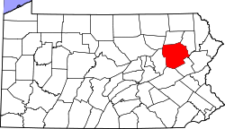
White Haven is a borough in Luzerne County, Pennsylvania, United States. It is located along the Lehigh River. The population was 1,163 at the 2020 census. [3]
White Haven was created in 1824 by industrialist Josiah White. It was incorporated as a borough in 1842.
Early European explorers to the Wyoming Valley encountered a new form of coal, known as anthracite, that was abundant throughout the Coal Region. Anthracite was a valuable commodity without a good use. On February 11, 1808, Wilkes-Barre Judge Jesse Fell created the first iron grate in the valley to successfully burn anthracite. This invention increased the popularity of anthracite as a fuel source. This led to the expansion of the coal industry in Northeastern Pennsylvania.
Throughout the 1800s, canals and railroads were constructed to aid in the mining and transportation of coal. Luzerne County witnessed a population boom with the expansion of the coal mining industry.
The Lehigh Coal and Navigation Company chartered the Lehigh and Susquehanna Railroad on March 31, 1837, in order to link Wilkes-Barre to White Haven. [4] Construction of the railroad began in 1839 and was completed in the 1840s. [5] The arduous 19.58-mile (31.51 km) route required the construction of a tunnel and three inclined planes, including Ashley Planes. [6]
With the completion of the Lehigh and Susquehanna Railroad, the canal industry, which had existed for no more than one generation, faced a rapid extinction. The Lehigh and Susquehanna Railroad moved Wyoming Valley anthracite from its various coal fields to White Haven over the Appalachian Mountains that had posed such a challenge to settlers for 150 years prior to the development of these rail lines.
Once the Lehigh and Susquehanna Railroad reached White Haven, an extensive transportation network expeditiously and economically delivered the Wyoming Valley's anthracite to a waiting market. By 1867, the Lehigh Valley Railroad, which was first established in the Hazleton area's coal fields, was linked to Wilkes-Barre, and then in 1869, the Lehigh Valley Railroad was connected to other rail systems in New York state.
White Haven is located at 41°3′34″N75°46′34″W / 41.05944°N 75.77611°W (41.059532, -75.776123). [7] The borough is 17 miles (27 km) south of Wilkes-Barre, and 4 miles (6 km) west of the I-476 and I-80 interchange. According to the U.S. Census Bureau, the borough has a total area of 1.2 square miles (3.2 km2), of which 1.2 square miles (3.2 km2) is land and 0.04 square miles (0.1 km2), or 2.12%, is water. [8] White Haven's elevation is 1,221 feet (372 m) above sea level.
Lehigh Gorge State Park, which encompasses the Lehigh River, provides White Haven and the surrounding communities with a plethora of recreational activities. Water released from the Francis E. Walter Dam makes the river deep enough for boating. White water rafting is a very popular recreational activity in the park. Other activities include fishing, hiking, bicycling, sight-seeing, snowmobiling, and much more. [9]
Census | Pop. | Note | %± |
---|---|---|---|
1860 | 943 | — | |
1870 | 1,321 | 40.1% | |
1880 | 1,408 | 6.6% | |
1890 | 1,634 | 16.1% | |
1900 | 1,517 | −7.2% | |
1910 | 1,438 | −5.2% | |
1920 | 1,402 | −2.5% | |
1930 | 1,537 | 9.6% | |
1940 | 1,528 | −0.6% | |
1950 | 1,461 | −4.4% | |
1960 | 1,778 | 21.7% | |
1970 | 1,203 | −32.3% | |
1980 | 1,218 | 1.2% | |
1990 | 1,132 | −7.1% | |
2000 | 1,182 | 4.4% | |
2010 | 1,097 | −7.2% | |
2020 | 1,163 | 6.0% | |
2021 (est.) | 1,164 | [3] | 0.1% |
U.S. Decennial Census [10] |
As of the census [11] of 2000, there were 1,182 people, 468 households, and 329 families residing in the borough. The population density was 982.1 inhabitants per square mile (379.2/km2). There were 515 housing units at an average density of 427.9 per square mile (165.2/km2). The racial makeup of the borough was 98.39% White, 0.08% Native American, 1.27% Asian, and 0.25% from two or more races. Hispanic or Latino of any race were 0.76% of the population.
The main ancestries reported by White Haven residents on the 2000 Census were Polish, with 17% of the population, Italian with 13%, Irish with 10%, Slovak with 8%, and German with 6%. However, Czechoslovakian, Carpatho Rusyn, Eastern European and Slavic were all reported by about one percent of the population, so the Slovak population might have come in second to Polish if the census had allowed reporting of more than two ancestries.
There were 468 households, out of which 34.0% had children under the age of 18 living with them, 52.6% were married couples living together, 12.8% had a female householder with no husband present, and 29.5% were non-families. 26.5% of all households were made up of individuals, and 14.1% had someone living alone who was 65 years of age or older. The average household size was 2.53 and the average family size was 3.06.
In the borough the population was spread out, with 27.3% under the age of 18, 7.3% from 18 to 24, 28.0% from 25 to 44, 20.9% from 45 to 64, and 16.5% who were 65 years of age or older. The median age was 37 years. For every 100 females there were 87.3 males. For every 100 females age 18 and over, there were 88.8 males.
The median income for a household in the borough was $37,438, and the median income for a family was $43,846. Males had a median income of $32,159 versus $27,386 for females. The per capita income for the borough was $18,768. About 4.5% of families and 6.4% of the population were below the poverty line, including 8.3% of those under age 18 and 8.8% of those age 65 or over.
The school district is the Crestwood School District. [12]
Wilkes-Barre is a city in and the county seat of Luzerne County, Pennsylvania, United States. Located at the center of the Wyoming Valley in Northeastern Pennsylvania, it had a population of 44,328 in the 2020 census. It is the second-largest city, after Scranton, in the Scranton–Wilkes-Barre–Hazleton, PA Metropolitan Statistical Area, which had a population of 567,559 as of the 2020 census, making it the fifth-largest metropolitan area in Pennsylvania after the Delaware Valley, Greater Pittsburgh, the Lehigh Valley, and Greater Harrisburg.
Luzerne County is a county in the Commonwealth of Pennsylvania. According to the United States Census Bureau, the county has a total area of 906 square miles (2,350 km2), of which 890 square miles (2,300 km2) is land and 16 square miles (41 km2) is water. It is Northeastern Pennsylvania's second-largest county by total area. As of the 2020 census, the population was 325,594, making it the most populous county in the northeastern part of the state. The county seat and most populous city is Wilkes-Barre. Other populous communities include Hazleton, Kingston, Nanticoke, and Pittston. Luzerne County is included in the Scranton–Wilkes-Barre–Hazleton Metropolitan Statistical Area, which has a total population of 555,426 as of 2017. The county is part of the Northeast Pennsylvania region of the state.
Carbon County is a county in the Commonwealth of Pennsylvania. As of the 2020 census, the population was 64,749. The county is part of the Northeast Pennsylvania region of the state.
Beaver Meadows is a borough in Carbon County, Pennsylvania, United States. It is part of Northeastern Pennsylvania. The population was 897 at the 2020 U.S. census.
Bear Creek Township is a township in Luzerne County, Pennsylvania, United States. The township has a total area of 67.8 square miles (176 km2), making it is the largest municipality in Luzerne County. The population was 2,752 at the 2020 census.
Exeter is a borough in the Greater Pittston-Wilkes-Barre area of Luzerne County, Pennsylvania, United States, about 10 miles (16 km) west of Scranton and a few miles north of Wilkes-Barre. It is located on the western bank of the Susquehanna River and has a total area of 5.0 square miles (12.9 km2). As of 2020, Exeter had a population of 5,513.
Forty Fort is a borough in Luzerne County, Pennsylvania, United States. The population was 4,233 at the 2020 census. Its neighbors are Wyoming, Plains Township, Kingston, and Swoyersville. The Wilkes-Barre Wyoming Valley Airport and the Wyoming Seminary Lower School are both located in the borough.
Hanover Township is a township in Luzerne County, Pennsylvania. As of the 2020 census, the population was 11,424, making it the most populous township in the county.
Jenkins Township is a township in the Greater Pittston area of Luzerne County, Pennsylvania, United States. The population was 4,282 at the 2020 census.
Kingston is a borough in Luzerne County, Pennsylvania, United States. It is located on the western bank of the Susquehanna River opposite Wilkes-Barre. Kingston was first settled in the early 1770s, and incorporated as a borough in 1857. As of the 2020 census, the population was 13,349, making it the most populous borough in Luzerne County.
Larksville is a borough in Luzerne County, Pennsylvania, United States. It is 2 miles (3 km) west of Wilkes Barre on the Susquehanna River. The population was 4,216 as of the 2020 census.
Mountain Top is an unincorporated area and census-designated place (CDP) in Luzerne County, Pennsylvania, United States. As of the 2010 census, its population was 10,982.
Pittston is a city in Luzerne County, Pennsylvania, United States. The city lies in the Wyoming Valley on the east side of the Susquehanna River and on the south side of the Lackawanna River. It is approximately midway between Wilkes-Barre and Scranton. Pittston is 68.7 miles (110.6 km) north of Allentown and 129.2 miles (207.9 km) northwest of New York City.
Pittston Township is a township in Luzerne County, Pennsylvania. The population was 3,179 as of the 2020 census. The township is located within the Greater Pittston region. As of 2010, the total population of Greater Pittston was 48,020. The Wilkes-Barre/Scranton International Airport is located in Pittston Township.
Plains Township is a township in Luzerne County, Pennsylvania, United States. The population was 9,816 at the 2020 census. The municipality is the birthplace of Chicago White Sox hall of famer Ed Walsh and John J. Yeosock, a United States Army general who commanded the 3rd U.S. Army during Operation Desert Shield and Operation Desert Storm. Mohegan Pennsylvania is a casino in Plains Township.
Plymouth is a borough in Luzerne County, Pennsylvania, United States, located 4 miles (6 km) west of Wilkes-Barre, along the Susquehanna River. The population was 5,763 as of the 2020 census.
Plymouth Township is located in Luzerne County, Pennsylvania, United States. The population was 1,712 at the 2020 census.
Wyoming is a borough in the Greater Pittston area of Luzerne County, Pennsylvania, United States. It is located 5 miles (8 km) north of Wilkes-Barre, along the Susquehanna River. The population was 3,097 as of the 2020 census.
Wilkes-Barre Township is a township with home rule status in Luzerne County, Pennsylvania, United States. It is adjacent to the city of Wilkes-Barre. The population of the township was 3,219 at the 2020 census.
The Wyoming Valley is a historic industrialized region of Northeastern Pennsylvania. The region is historically notable for its influence in helping fuel the American Industrial Revolution with its many anthracite coal mines. As a metropolitan area, it is known as the Scranton–Wilkes-Barre metropolitan area, after its principal cities, Scranton and Wilkes-Barre. With a population of 567,559 as of the 2020 United States census, it is the fifth-largest metropolitan area in Pennsylvania, after the Delaware Valley, Greater Pittsburgh, the Lehigh Valley, and the Harrisburg–Carlisle metropolitan statistical areas.
{{cite web}}
: |last1=
has generic name (help)