Rice Township, Pennsylvania

Last updated

Rice Township, Pennsylvania
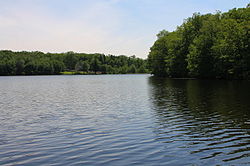
The Ice Ponds 2.JPG
The Ice Ponds in Rice Township
Map of Luzerne County, Pennsylvania Highlighting Rice Township.PNG
Map of Luzerne County highlighting Rice Township
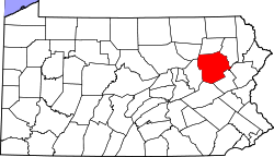
Map of Pennsylvania highlighting Luzerne County.svg
Map of Pennsylvania highlighting Luzerne County
Country United States
State Pennsylvania
County Luzerne
Area
[1]
  Total11.18 sq mi (28.94 km2)
  Land10.93 sq mi (28.30 km2)
  Water0.25 sq mi (0.65 km2)
Population
 (2020) [2]
  Total3,626 Increase2.svg
  Estimate 
(2021) [2]
3,660
  Density321.74/sq mi (124.22/km2)
Time zone UTC-5 (Eastern (EST))
  Summer (DST) UTC-4 (EDT)
FIPS code 42-079-64424
Website ricetwp.com

Rice Township is a township in Luzerne County, Pennsylvania, United States. The population was 3,626 at the 2020 census. [2]

Contents

History

The first recorded white settler in the vicinity of modern-day Rice Township was Conrad Wickeiser in 1798. Samuel B. Stivers and William Vandermark were the first known white settlers in what is now Rice Township. Additional settlers entered the territory and constructed the first houses and sawmills. The first schoolhouse was erected in 1840. [3]

Rice Township was originally part of Hanover and Wright Townships. Hanover was granted to Captain Lazarus Stewart in 1770. On April 12, 1851, Wright Township was formed from a segment of Hanover Township; it was named after the Hon. Hendrick B. Wright of Wilkes-Barre. Rice Township was officially established in 1928 from a piece of Wright Township. In the 1920s and 30s, a major industry in Rice Township was the harvesting of ice, which was sold in both Wilkes-Barre and Hazleton. The ice industry faded with the growing popularity of the electric refrigerator. [3]

Geography

According to the United States Census Bureau, the township has a total area of 11.2 square miles (28.9 km2), of which 10.9 square miles (28.3 km2) is land and 0.23 square miles (0.6 km2), or 2.24%, is water. Rice is part of the Mountain Top region of Luzerne County. I-81 travels north to south through the western half of the township. Homes, businesses, thick forests, and lakes (e.g., Boyle Pond, Lake Blytheburn, Laurel Lakes, and The Ice Ponds) make up most of the municipality. There are several neighborhoods in Rice (one of which is Laurel Lakes). There are also several streams in the township (e.g., Big Wapwallopen Creek, Little Wapwallopen Creek, and Nuangola Outlet).

Rice Township sign.JPG
Rice Township welcome sign
The Ice Ponds 1.JPG
The Ice Ponds

Law enforcement

Law enforcement is provided by the Rice Township Police; they currently employ up to seven full-time officers, one part-time officer and a dual-purpose K-9 unit. [4]

Demographics

Historical population
CensusPop.Note
2000 2,460
2010 3,33535.6%
2020 3,6268.7%
2021 (est.)3,660 [2] 0.9%
U.S. Decennial Census [5]

As of the census [6] of 2000, there were 2,460 people, 907 households, and 696 families living in the township. The population density was 222.0 inhabitants per square mile (85.7/km2). There were 950 housing units at an average density of 85.7 per square mile (33.1/km2). The racial makeup of the township was 96.67% White, 0.49% African American, 2.03% Asian, 0.37% from other races, and 0.45% from two or more races. Hispanic or Latino of any race were 1.67% of the population.

There were 907 households, out of which 37.0% had children under the age of 18 living with them, 66.6% were married couples living together, 7.3% had a female householder with no husband present, and 23.2% were non-families. 19.6% of all households were made up of individuals, and 7.1% had someone living alone who was 65 years of age or older. The average household size was 2.71 and the average family size was 3.14.

In the township the population was spread out, with 26.7% under the age of 18, 6.2% from 18 to 24, 31.1% from 25 to 44, 25.9% from 45 to 64, and 10.2% who were 65 years of age or older. The median age was 38 years. For every 100 females, there were 93.5 males. For every 100 females age 18 and over, there were 92.2 males.

The median income for a household in the township was $52,888, and the median income for a family was $60,302. Males had a median income of $40,256 versus $24,952 for females. The per capita income for the township was $22,069. About 2.0% of families and 2.4% of the population were below the poverty line, including 4.3% of those under age 18 and 3.2% of those age 65 or over.

Related Research Articles

Salo Township is a township in Aitkin County, Minnesota, United States. The population was 102 as of the 2010 census.

Becker Township is a township in Cass County, Minnesota, United States. The population was 485 as of the 2000 census. Becker Township was named for J. A. Becker, a pioneer settler.

Beulah Township is a township in Cass County, Minnesota, United States. The population was 57 as of the 2000 census. Beulah Township was named for Beulah Olds, a pioneer settler.

<span class="mw-page-title-main">Goshen Township, Clearfield County, Pennsylvania</span> Township in Pennsylvania, United States

Goshen Township is a township in Clearfield County, Pennsylvania, United States. The population was 393 at the 2020 census.

<span class="mw-page-title-main">Conyngham Township, Luzerne County, Pennsylvania</span> Township in Pennsylvania

Conyngham Township is a township in Luzerne County, Pennsylvania, United States. The population was 1,309 at the 2020 census.

<span class="mw-page-title-main">Dallas Township, Pennsylvania</span> Township in Pennsylvania, United States

Dallas Township is a township in Luzerne County, Pennsylvania, United States. It is part of the Back Mountain, a 118 square mile region in northern Luzerne County. The population was 9,124 at the 2020 census.

<span class="mw-page-title-main">Dennison Township, Pennsylvania</span> Township in Pennsylvania, United States

Dennison Township is a township in Luzerne County, Pennsylvania, United States. The population was 961 at the 2020 census.

<span class="mw-page-title-main">Dorrance Township, Pennsylvania</span> Township in Pennsylvania, United States

Dorrance Township is a township in Luzerne County, Pennsylvania, United States. The population was 2,077 at the 2020 census.

<span class="mw-page-title-main">Fairmount Township, Pennsylvania</span> Township in Pennsylvania, United States

Fairmount Township is a township in Luzerne County, Pennsylvania, United States. The population was 1,207 at the 2020 census. Fairmount Township is home to Ricketts Glen State Park. The park receives tens of thousands of visitors each year.

<span class="mw-page-title-main">Fairview Township, Luzerne County, Pennsylvania</span> Township in Pennsylvania, United States

Fairview Township is a township in Luzerne County, Pennsylvania, United States. The population was 4,691 at the 2020 census.

<span class="mw-page-title-main">Franklin Township, Luzerne County, Pennsylvania</span> Township in Pennsylvania, United States

Franklin Township is a township in Luzerne County, Pennsylvania, United States. It is part of the Back Mountain, a 118 square mile region in northern Luzerne County. The population was 1,712 at the 2020 census.

<span class="mw-page-title-main">Hanover Township, Luzerne County, Pennsylvania</span> Township in Pennsylvania, United States

Hanover Township is a township in Luzerne County, Pennsylvania. As of the 2020 census, the population was 11,424, making it the most populous township in the county.

<span class="mw-page-title-main">Hollenback Township, Pennsylvania</span> Township in Pennsylvania, United States

Hollenback Township is a township which is located in Luzerne County, Pennsylvania, United States. The population was 1,125 at the time of the 2020 census.

<span class="mw-page-title-main">Lehman Township, Luzerne County, Pennsylvania</span> Township in Pennsylvania, United States

Lehman Township is a township in Luzerne County, Pennsylvania, United States. The township is part of the Back Mountain. The campus of Penn State Wilkes-Barre is located at the Hayfield Farms on Old Route 115 in Lehman Township. The township population was 3,342 at the 2020 census.

<span class="mw-page-title-main">Mountain Top, Pennsylvania</span> Census-designated place in Pennsylvania, United States

Mountain Top is an unincorporated area and census-designated place (CDP) in Luzerne County, Pennsylvania, United States. As of the 2010 census, its population was 10,982.

<span class="mw-page-title-main">Nescopeck Township, Pennsylvania</span> Township in Pennsylvania, United States

Nescopeck Township is a township in Luzerne County, Pennsylvania, United States. As of the 2020 census, the township population was 1,080.

<span class="mw-page-title-main">Nuangola, Pennsylvania</span> Borough in Pennsylvania, United States

Nuangola is a borough in Luzerne County, Pennsylvania. The population was 663 as of the 2020 census. Developed as a summer resort in the early 20th century, the borough is built around a heart-shaped lake called Nuangola Lake.

<span class="mw-page-title-main">Ross Township, Luzerne County, Pennsylvania</span> Township in Pennsylvania, United States

Ross Township is a township in Luzerne County, Pennsylvania, United States. The population was 2,719 at the 2020 census.

<span class="mw-page-title-main">Salem Township, Luzerne County, Pennsylvania</span> Township in Pennsylvania, United States

Salem Township is a township in Luzerne County, Pennsylvania, United States. The population was 4,019 at the 2020 census. The Susquehanna Steam Electric Station, a nuclear power plant, is located in Salem.

<span class="mw-page-title-main">Wright Township, Pennsylvania</span> Township in Pennsylvania, United States

Wright Township is a township in Luzerne County, Pennsylvania, United States. The population was 5,726 at the 2020 census.

References

  1. "2016 U.S. Gazetteer Files". United States Census Bureau. Retrieved August 14, 2017.
  2. 1 2 3 4 Bureau, US Census. "City and Town Population Totals: 2020—2021". Census.gov. US Census Bureau. Retrieved August 4, 2022.
  3. 1 2 "History, Rice township, Luzerne Co., Pa". www.pagenweb.org. Retrieved December 25, 2018.
  4. "Police - Rice Township". ricetwp.com. Retrieved December 25, 2018.
  5. "Census of Population and Housing". Census.gov. Retrieved June 4, 2016.
  6. "U.S. Census website". United States Census Bureau . Retrieved January 31, 2008.

41°10′00″N75°55′59″W / 41.16667°N 75.93306°W / 41.16667; -75.93306