Suscon, Pennsylvania | |
---|---|
Coordinates: 41°18′8″N75°43′21″W / 41.30222°N 75.72250°W | |
Country | United States |
State | Pennsylvania |
County | Luzerne |
Township | Pittston |
Time zone | UTC-5 (Eastern (EST)) |
• Summer (DST) | UTC-4 (EDT) |
ZIP code | 18640 |
Area code | 570 |
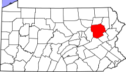
Suscon is an unincorporated community in Pittston Township, Luzerne County, Pennsylvania, United States, northeast of Wilkes-Barre and south of Scranton. It is named for its position at the former junction of the Susquehanna Connecting Railroad and the Wilkes-Barre and Eastern Railroad (both subsidiaries of the New York, Susquehanna and Western Railway). It uses the Pittston zip code of 18640. [1]
Suscon is notable for being the home of the urban legend "The Suscon Screamer." [2]
An EF2 tornado struck Suscon (Pittston Township) on Saturday, February 25, 2017. It was on the ground from 2:30 pm to 2:50 pm. This is the first tornado in February for Luzerne County in recorded history. [3] [4] The tornado generated top wind speeds of 120 mph, had a maximum width of 500 yards, and traveled 12.8 miles. [5]
Suscon is located in the eastern part of Pittston Township. It is mostly made up of mountains and forests.
Wilkes-Barre is a city in and the county seat of Luzerne County, Pennsylvania, United States. Located at the center of the Wyoming Valley in Northeastern Pennsylvania, it had a population of 44,328 in the 2020 census. It is the second-largest city, after Scranton, in the Scranton–Wilkes-Barre–Hazleton, PA Metropolitan Statistical Area, which had a population of 567,559 as of the 2020 census, making it the fifth-largest metropolitan area in Pennsylvania after the Delaware Valley, Greater Pittsburgh, the Lehigh Valley, and Greater Harrisburg.
Luzerne County is a county in the Commonwealth of Pennsylvania. According to the United States Census Bureau, the county has a total area of 906 square miles (2,350 km2), of which 890 square miles (2,300 km2) is land and 16 square miles (41 km2) is water. It is Northeastern Pennsylvania's second-largest county by total area. As of the 2020 census, the population was 325,594, making it the most populous county in the northeastern part of the state. The county seat and largest city is Wilkes-Barre. Other populous communities include Hazleton, Kingston, Nanticoke, and Pittston. Luzerne County is included in the Scranton–Wilkes-Barre–Hazleton Metropolitan Statistical Area, which has a total population of 555,426 as of 2017.
Exeter is a borough in the Greater Pittston-Wilkes-Barre area of Luzerne County, Pennsylvania, United States, about 10 miles (16 km) west of Scranton and a few miles north of Wilkes-Barre. It is located on the western bank of the Susquehanna River and has a total area of 5.0 square miles (12.9 km2). As of 2020, Exeter had a population of 5,513.
Pittston is a city in Luzerne County, Pennsylvania, United States. The city lies in the Wyoming Valley on the east side of the Susquehanna River and on the south side of the Lackawanna River. It is approximately midway between Wilkes-Barre and Scranton. Named after the British statesman William Pitt the Elder, the city was settled around 1770 by the Susquehanna Company of Connecticut. It was originally called "Pittstown." The city gained prominence in the late 19th and early 20th centuries as an active anthracite coal mining city, drawing a large portion of its labor force from European immigrants. The population was 7,591 as of the 2020 census, making it Luzerne County's fourth-largest city.
Pittston Township is a township in Luzerne County, Pennsylvania. The population was 3,179 as of the 2020 census. The township is located within the Greater Pittston region. As of 2010, the total population of Greater Pittston was 48,020. The Wilkes-Barre/Scranton International Airport is located in Pittston Township.
Plains Township is a township in Luzerne County, Pennsylvania, United States. The population was 9,816 at the 2020 census. The municipality is the birthplace of Chicago White Sox hall of famer Ed Walsh and John J. Yeosock, a United States Army general who commanded the 3rd U.S. Army during Operation Desert Shield and Operation Desert Storm. Mohegan Pennsylvania is a casino in Plains Township.
Wilkes-Barre Township is a township with home rule status in Luzerne County, Pennsylvania, United States. It is adjacent to the city of Wilkes-Barre. The population of the township was 3,219 at the 2020 census.
The Wyoming Valley is a historic industrialized region of Northeastern Pennsylvania. The region is historically notable for its influence in helping fuel the American Industrial Revolution with its many anthracite coal-mines. As a metropolitan area, it is known as the Scranton/Wilkes-Barre metropolitan area, after its principal cities, Scranton and Wilkes-Barre. With a population of 567,559 as of the 2020 United States census, it is the fifth-largest metropolitan area in Pennsylvania, after the Delaware Valley, Greater Pittsburgh, the Lehigh Valley, and the Harrisburg–Carlisle metropolitan statistical areas.
Northeastern Pennsylvania (NEPA) is a region of the U.S. state of Pennsylvania that includes the Pocono Mountains, the Endless Mountains, and the industrial cities of Scranton, Wilkes-Barre, Pittston, Hazleton, Nanticoke, and Carbondale. A portion of this region is located in the New York City metropolitan area.
Area codes 570 and 272 are telephone area codes in the North American Numbering Plan (NANP) for the northeast quadrant of the U.S. state of Pennsylvania. The numbering plan area (NPA) includes the cities or towns of Scranton, Wilkes-Barre, Williamsport, Stroudsburg, East Stroudsburg, Pittston, Carbondale, Hazleton, Clarks Summit, Towanda, Bloomsburg, Sayre, Tunkhannock, Berwick, Milford, Montrose, Honesdale, Pocono Pines, Nanticoke, Tamaqua, Shavertown, Dallas, Mahanoy City, Sunbury, Jim Thorpe, and as far south as Pottsville and as far west as Lock Haven.
Greater Pittston is a 65.35 sq mi (169.3 km2) region in Luzerne County, Pennsylvania, in reference to the area in and around Pittston. As of 2010, the total population of Greater Pittston is 48,020. This region includes Avoca, Dupont, Duryea, Exeter Boro, Exeter Township, Hughestown, Jenkins Township, Laflin, Pittston Township, West Pittston, West Wyoming, Wyoming, and Yatesville. It is a subregion of Wyoming Valley.
Pennsylvania Route 315 is an 8.2-mile-long (13.2 km) state highway located in Luzerne County, Pennsylvania. The southern terminus is at an interchange with the PA 309 freeway and the northern terminus of PA 309 Business in Wilkes-Barre. The northern terminus is at the entrance of the Wilkes-Barre/Scranton International Airport in Pittston Township just past an interchange with Interstate 81 (I-81). PA 315 heads northeast from PA 309 and PA 309 Bus. as a multilane road through suburban development in the Wyoming Valley parallel to I-81. The route comes to an interchange with I-81 and I-476 before passing through Dupont along a one-way pair. Past here, PA 315 follows a divided highway to I-81 and the airport.
The Lackawanna and Bloomsburg Railroad (LBR) was an 80-mile (130 km) long 19th century railroad that ran between Scranton and Northumberland in Pennsylvania in the United States. Incorporated in 1852, the railroad began operation in 1856 and was taken over by the Delaware, Lackawanna and Western Railroad in 1873. The western end of the line, from Northumberland to Beach Haven, is still in operation as the shortline North Shore Railroad.
The Luzerne County Transportation Authority (LCTA) is the operator of mass transportation in the city of Wilkes-Barre, Pennsylvania, and portions of surrounding Luzerne County. Services provided by the LCTA replaced previously offered services of the White Transit Company and Wilkes-Barre Transit Corporation, under a purchase-of-service agreement in 1972.
Mill Creek is a tributary of the Susquehanna River in Luzerne County, Pennsylvania in the United States. It is 8.7 miles (14.0 km) long. Its watershed is approximately 36 square miles in area. The creek flows through Plains Township, Bear Creek Township, and Wilkes-Barre.
Old Boston is an unincorporated community in Jenkins Township, Luzerne County, Pennsylvania. It is located in the Wyoming Valley, east of Interstate 81 and along Interstate 476, just south of the Wyoming Valley Interchange of the Pennsylvania Turnpike. WVIA-TV, the Scranton/Wilkes-Barre PBS affiliate, is located in Old Boston, which uses the Pittston ZIP code of 18640.
The Wyoming Division Canal was an anthracite canal in Luzerne County, Pennsylvania, in the United States. It was a branch of the North Branch Canal, which was one of only two major canals in Pennsylvania to be owned by the state. The creek went from West Nanticoke to Pittston, going through Luzerne County.
Solomon Creek is a tributary of the Susquehanna River in Luzerne County, Pennsylvania, in the United States. It is approximately 8.8 miles (14.2 km) long and flows through Fairview Township, Hanover Township, and Wilkes-Barre. The creek is affected by acid mine drainage and has significant loads of iron, aluminum, and manganese. The creek's named tributaries are Spring Run, Sugar Notch Run, and Pine Creek. The Solomon Creek watershed is located in the Anthracite Valley section of the ridge-and-valley geographical province. Major rock formations in the watershed include the Mauch Chunk Formation, the Spechty Kopf Formation, and the Catskill Formation.
Lidy Creek is a tributary of Mill Creek in Luzerne County, Pennsylvania, in the United States. It is approximately 1.9 miles (3.1 km) long and flows through Pittston Township and Dupont. The watershed of the creek has an area of 1.50 square miles (3.9 km2). It is a Coldwater Fishery and is not impaired. The creek is in the vicinity of the Wilkes-Barre/Scranton International Airport and the International Trade Zone Industrial Park.
Spring Brook is a tributary of the Lackawanna River in Lackawanna County and Luzerne County, in Pennsylvania, in the United States. It is approximately 17 miles (27 km) long and flows through Covington Township, Spring Brook Township, and Moosic in Lackawanna County and Pittston Township in Luzerne County. The watershed of the stream has an area of 57.2 square miles (148 km2). It is designated as a High-Quality Coldwater Fishery and a Migratory Fishery above Interstate 476 and as a Coldwater Fishery and a Migratory Fishery below it. A section is also designated as Class A Wild Trout Waters. The stream's tributaries include Panther Creek, Plank Bridge Creek, Rattlesnake Creek, Green Run, Monument Creek, and Covey Swamp Creek. It has a relatively high level of water quality and is very slightly acidic, with a pH of 6.4 to 6.9.