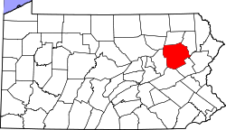
Sandy Run, Pennsylvania | |
---|---|
Coordinates: 41°01′10″N75°51′25″W / 41.01944°N 75.85694°W Coordinates: 41°01′10″N75°51′25″W / 41.01944°N 75.85694°W | |
Country | United States |
State | Pennsylvania |
County | Luzerne |
Township | Foster |
Elevation | 1,654 ft (504 m) |
Time zone | UTC-5 (Eastern (EST)) |
• Summer (DST) | UTC-4 (EDT) |
Area code(s) | 570 & 272 |
GNIS feature ID | 1186959 [1] |
Sandy Run is an unincorporated community in Foster Township, Luzerne County, Pennsylvania, United States. [1] [2]
Luzerne County is a county in the Commonwealth of Pennsylvania. The county has a total area of 906 square miles (2,350 km2) of which 890 square miles (2,300 km2) is land and 16 square miles (41 km2) is water, according to the U.S. Census Bureau. It is Northeastern Pennsylvania's second-largest county by total area and Northeast Pennsylvania's most populous county, with a population of 325,594 as of the 2020 census.
Kidder Township is a township in Carbon County, Pennsylvania, United States. The population was 1,935 at the 2010 census, up from 1,185 at the 2000 census.
Bear Creek Township is a township in Luzerne County, Pennsylvania, United States. The township has a total area of 67.8 square miles (176 km2), making it is the largest municipality in Luzerne County. The population was 2,774 at the 2010 census.
Butler Township is a township in Luzerne County, Pennsylvania, United States. The population was 9,221 at the 2010 census.
Foster Township is a township in Luzerne County, Pennsylvania, United States. The population was 3,467 at the 2010 census. Foster Township police services are provided by White Haven Police Department. Emergency medical services are provided jointly by Freeland Northside Community Ambulance and White Haven Rescue Unit. Fearnots Volunteer Fire Company is Foster Township's Fire Department.
Hollenback Township is a township in Luzerne County, Pennsylvania, United States. The population was 1,196 at the 2010 census.
Ross Township is a township in Luzerne County, Pennsylvania, United States. The population was 2,937 at the 2010 census.
Harveys Creek is a tributary of the Susquehanna River in Luzerne County, Pennsylvania, in the United States. It is approximately 14.5 miles (23.3 km) long and flows through Harveys Lake, Lake Township, Lehman Township, Jackson Township, and Plymouth Township. The creek's watershed has an area of 46.3 square miles (120 km2). The creek has four named tributaries, which are known as Bear Hollow Creek, Paint Spring Run, Pikes Creek, and East Fork Harveys Creek. The watershed is designated as a High-Quality Coldwater Fishery and a Migratory Fishery above Pikes Creek and as a Coldwater Fishery and a Migratory Fishery below it. The creek's source is Harveys Lake, the largest natural lake in Pennsylvania.
East Sandy Creek is a tributary of the Allegheny River in Northwestern Pennsylvania in the United States.
Lehigh Gorge State Park is a 4,548 acres (1,841 ha) Pennsylvania state park in Luzerne and Carbon Counties, Pennsylvania in the United States. The park encompasses a gorge, the|Lehigh Gorge, which stretches along the Lehigh River from a U.S. Army Corps of Engineers flood control dam in Luzerne County to Jim Thorpe in Carbon County. The primary recreational activity at Lehigh Gorge State Park is white water rafting.
Huntington Creek is a tributary of Fishing Creek in Luzerne and Columbia counties, Pennsylvania, in the United States. It is approximately 29.5 miles (47.5 km) long.
The Hazleton Area School District is a large, rural public school district in Pennsylvania, stretching over portions of Luzerne, Schuylkill, and Carbon Counties. Its headquarters are in Hazle Township.
Oley Creek is a tributary of Nescopeck Creek in Luzerne County, Pennsylvania, in the United States. It is approximately 5.2 miles (8.4 km) long. It flows through Foster Township, Dennison Township, and Butler Township. Long Hollow is a tributary of the creek. The creek's watershed has an area of 7.2 square miles (19 km2). It is a high-quality coldwater fishery in its upper reaches and a Class A Wild Trout Fishery for part of its distance. The creek is in the upper reaches of the Nescopeck Creek watershed. It is named after a community in Berks County, Pennsylvania known as Oley.
Pine Creek is a tributary of Huntington Creek in Luzerne County and Columbia County, in Pennsylvania, in the United States. It is approximately 12.4 miles (20.0 km) long and flows through Fairmont Township, Huntington Township, and New Columbus in Luzerne County; and Fishing Creek Township in Columbia County. The creek's watershed has an area of 30.7 square miles and is located in Columbia and Luzerne Counties. Its tributaries include Bell Branch and Little Pine Creek. The vicinity of the creek was settled in the late 1700s. The main industries in the watershed in the early 1900s were timber and agriculture. Pine Creek is designated as a coldwater fishery and a migratory fishery. Northern myotis bats also inhabit areas near the creek.
Sugarloaf Creek is a tributary of Tomhicken Creek in Luzerne County and Schuylkill County, in Pennsylvania, in the United States. It is approximately 3.5 miles (5.6 km) long and flows through Hazle Township and Black Creek Township in Luzerne County and North Union Township in Schuylkill County. The watershed of the stream has an area of 3.34 square miles (8.7 km2). The stream is considered to be a Coldwater Fishery. The main rock formation in the stream's watershed are the Mauch Chunk Formation and the main soil is the Hazleton soil. The creek has been impaired by acid mine drainage from the Oneida Number One Tunnel.
Marsh Run is a tributary of Coles Creek in Luzerne County and Columbia County, in Pennsylvania, in the United States. It is approximately one mile (1.6 km) long and flows through Fairmount Township in Luzerne County and Sugarloaf Township in Columbia County. The stream's watershed has an area of 0.44 square miles (1.1 km2). Wild trout reproduce throughout the stream. It is named after marshes, which can be found in the vicinity of the stream. Alluvium and Wisconsinian Outwash area also present, as is bedrock consisting of sandstone and shale. The stream has one unnamed tributary.
Scotch Run (also known as Scotch Run Creek is a tributary of Black Creek in Luzerne County, Pennsylvania, in the United States. It is approximately 1.6 miles long and flows through Black Creek Township. The stream is fed by springs and is located at the base of Nescopeck Mountain. It has not been assessed by the Pennsylvania Fish and Boat Commission.
Beaver Run is a tributary of Bowman Creek in Luzerne County and Wyoming County, in Pennsylvania, in the United States. It is approximately 7.7 miles (12.4 km) long and flows through Lake Township in Luzerne County and Noxen Township in Wyoming County. The watershed of the stream has an area of 10.6 square miles (27 km2). It is not designated as an impaired waterbody. The surficial geology in its vicinity includes alluvial fan, alluvial terrace, alluvium, Wisconsinan Till, Wisconsinan Ice-Contact Stratified Drift, fill, wetlands, and bedrock.
Sugar Run is a tributary of Bowman Creek in Luzerne County and Wyoming County, in Pennsylvania, in the United States. It is approximately 1.8 miles (2.9 km) long and flows through Lake Township in Luzerne County and Noxen Township in Wyoming County. The watershed of the stream has an area of 1.02 square miles (2.6 km2). The surficial geology in its vicinity consists of alluvium, alluvial fan, Wisconsinan Till, and bedrock. The stream's watershed is designated as a High-Quality Coldwater Fishery and a Migratory Fishery.
Cranberry is an unincorporated community in Hazle Township, Luzerne County, Pennsylvania, United States.