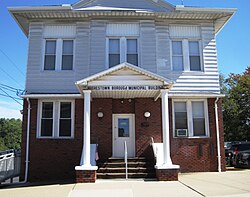
Hughestown, Pennsylvania

Last updated
Hughestown, Pennsylvania
Borough
Pittston City.jpg
An image of Greater Pittston. Hughestown can be seen in the foreground.
Luzerne County Pennsylvania Incorporated and Unincorporated areas Hughestown Highlighted.svg
Location of Hughestown in Luzerne County, Pennsylvania.
USA Pennsylvania location map.svg
Red pog.svg
Hughestown
Usa edcp location map.svg
Red pog.svg
Hughestown
Coordinates: 41°19′38″N75°46′31″W / 41.32722°N 75.77528°W / 41.32722; -75.77528 Coordinates: 41°19′38″N75°46′31″W / 41.32722°N 75.77528°W / 41.32722; -75.77528
Country United States
State Pennsylvania
County Luzerne
Region Greater Pittston
Settled1836
Incorporated1879
Government
  TypeBorough Council
  MayorWayne D. Quick, Jr.
Area
[1]
  Total0.87 sq mi (2.25 km2)
  Land0.87 sq mi (2.25 km2)
  Water0.00 sq mi (0.00 km2)
Population
 (2020) [2]
  Total1,329
  Density1,527.59/sq mi (589.82/km2)
Time zone UTC-5 (Eastern (EST))
  Summer (DST) UTC-4 (EDT)
Area code 570
FIPS code 42-36152

Hughestown is a borough in the Greater Pittston area of Luzerne County, Pennsylvania, United States. The population was 1,326 at the 2020 census. [3]

Contents

History

In 1934, the right arm of Hughestown resident Harry Tompkins was crushed by an Erie Railroad train. The resulting U.S. Supreme Court case, Erie Railroad Co. v. Tompkins , laid the foundation for a large part of modern American civil procedure.

Geography

According to the United States Census Bureau, the borough has a total area of 0.93 square miles (2.4 km2), all land. U.S. Route 11 runs through the southern portion of the borough. Hughestown is served by the Pittston Area School District. Robert Yaple Memorial Park is located in central Hughestown. Most of the homes and businesses are located in the western portion of the borough, while the eastern section consists of mostly forests and culm banks.

Demographics

Historical population
CensusPop.
1880 1,192
1890 1,45422.0%
1900 1,5486.5%
1910 2,02430.7%
1920 2,24410.9%
1930 2,2520.4%
1940 2,3403.9%
1950 1,888−19.3%
1960 1,615−14.5%
1970 1,407−12.9%
1980 1,78326.7%
1990 1,734−2.7%
2000 1,541−11.1%
2010 1,392−9.7%
2020 1,326−4.7%
2021 (est.)1,329 [3] 0.2%
Sources: [4] [5] [6] [2]

At the 2000 census there were 1,541 people, 615 households, and 444 families living in the borough. The population density was 1,734.6 people per square mile (668.5/km2). There were 659 housing units at an average density of 741.8 per square mile (285.9/km2). The racial makeup of the borough was 99.35% White, 0.13% African American, 0.06% Pacific Islander, 0.13% from other races, and 0.32% from two or more races. Hispanic or Latino of any race were 0.13%. [5]

There were 615 households, 25.2% had children under the age of 18 living with them, 57.6% were married couples living together, 10.4% had a female householder with no husband present, and 27.8% were non-families. 24.6% of households were made up of individuals, and 13.8% were one person aged 65 or older. The average household size was 2.50 and the average family size was 2.98.

The age distribution was 19.1% under the age of 18, 7.1% from 18 to 24, 27.1% from 25 to 44, 28.5% from 45 to 64, and 18.2% 65 or older. The median age was 43 years. For every 100 females there were 97.3 males. For every 100 females age 18 and over, there were 88.2 males.

The median household income was $41,750 and the median family income was $50,938. Males had a median income of $33,611 versus $22,422 for females. The per capita income for the borough was $20,246. About 4.7% of families and 5.7% of the population were below the poverty line, including 4.2% of those under age 18 and 7.1% of those age 65 or over.

Government

Hughestown's current mayor is Wayne D. Quick, Jr., and the President of Council is Robert Gable.

Related Research Articles

<span class="mw-page-title-main">South Heights, Pennsylvania</span> Borough in Pennsylvania, United States

South Heights is a borough in Beaver County, Pennsylvania, along the Ohio River. The population was 389 at the 2020 census. South Heights was first known as Ethel's Landing, a docking point on the Ohio River. The name of the town was changed to Shannopin when the Pittsburgh and Lake Erie Railroad established a station there. When the name of the town was changed to South Heights, the station became known as South Heights Station.

<span class="mw-page-title-main">Springboro, Pennsylvania</span> Borough in Pennsylvania, United States

Springboro is a borough in Crawford County, Pennsylvania, United States, located 35 miles southwest of Erie. The population was 377 at the 2020 census, down from 477 at the 2010 census.

<span class="mw-page-title-main">Elk Creek Township, Erie County, Pennsylvania</span> Township in Pennsylvania, United States

Elk Creek Township is a township in Erie County, Pennsylvania, United States. The population was 1,788 at the 2020 census, down from 1,798 at the 2010 census.

<span class="mw-page-title-main">Girard Township, Erie County, Pennsylvania</span> Township in Pennsylvania, United States

Girard Township is a township in Erie County, Pennsylvania, United States. The population was 4,882 at the 2020 census, down from the population of 5,102 at the 2010 census.

<span class="mw-page-title-main">Harborcreek Township, Erie County, Pennsylvania</span> Township in Pennsylvania, United States

Harborcreek Township is a township in Erie County, Pennsylvania, United States. The population was 16,586 at the 2020 census, down from 17,234 at the 2010 census, up from 15,178 in 2000. It is part of the Erie Metropolitan Statistical Area.

<span class="mw-page-title-main">Lake City, Pennsylvania</span> Borough in Pennsylvania, United States

Lake City is a borough in Erie County, Pennsylvania, United States. The population was 2,936 at the 2020 census. It is part of the Erie Metropolitan Statistical Area.

<span class="mw-page-title-main">McKean, Pennsylvania</span> Borough in Pennsylvania, United States

McKean is a borough in Erie County, Pennsylvania, United States. The population was 475 at the 2020 census. It is part of the Erie Metropolitan Statistical Area. McKean was known as "Middleboro" until it officially changed its name in 1970.

<span class="mw-page-title-main">McKean Township, Erie County, Pennsylvania</span> Township in Pennsylvania, United States

McKean Township is a township in Erie County, Pennsylvania, United States. The population was 4,443 at the 2020 census, up from 4,409 at the 2010 census, down from 4,619 in 2000.

<span class="mw-page-title-main">North East, Pennsylvania</span> Borough in Pennsylvania, United States

North East is a borough in Erie County, Pennsylvania, United States, 14 miles (23 km) northeast of Erie. Located in the county's northeastern corner, the name comes from the geographical location. The population was 4,114 at the 2020 census, down from 4,294 in 2010. Fruit growing was an early economic endeavor, and is still to this day, as this is a popular area especially for cherries and grapes. There is an annual Cherry Festival in the summer and an annual Wine Country Harvest Festival in autumn. It is part of the Erie Metropolitan Statistical Area. It is the northernmost town in Pennsylvania.

<span class="mw-page-title-main">Platea, Pennsylvania</span> Borough in Pennsylvania, United States

Platea is a borough in Erie County, Pennsylvania, United States. The population was 443 at the 2020 census.

<span class="mw-page-title-main">Waterford, Pennsylvania</span> Borough in Pennsylvania, United States

Waterford is a borough in Erie County, Pennsylvania, United States. The population was 1,475 at the 2020 census. It is part of the Erie Metropolitan Statistical Area.

<span class="mw-page-title-main">Wattsburg, Pennsylvania</span> Borough in Pennsylvania, United States

Wattsburg is a borough in Erie County, Pennsylvania, United States. The population was 352 at the 2020 census. It is part of the Erie Metropolitan Statistical Area.

<span class="mw-page-title-main">Avoca, Pennsylvania</span> Borough in Pennsylvania, United States

Avoca is a borough within the Greater Pittston area of Luzerne County, Pennsylvania. It is located 7.5 miles (12.1 km) northeast of Wilkes Barre and 3.4 miles (5.5 km) southwest of Scranton. The population was 2,501 at the time of the 2020 census. The Wilkes-Barre/Scranton International Airport (AVP) is located near Avoca.

<span class="mw-page-title-main">Dupont, Pennsylvania</span> Borough in Pennsylvania, United States

Dupont is a borough in the Greater Pittston area of Luzerne County, Pennsylvania, United States. The population was 2,536 as of the 2020 census.

<span class="mw-page-title-main">Exeter, Pennsylvania</span> Borough in Pennsylvania, United States

Exeter is a borough in the Greater Pittston-Wilkes-Barre area of Luzerne County, Pennsylvania, United States, about 10 miles (16 km) west of Scranton and a few miles north of Wilkes-Barre. It is located on the western bank of the Susquehanna River and has a total area of 5.0 square miles (12.9 km2). As of 2020, Exeter had a population of 5,513.

<span class="mw-page-title-main">Laflin, Pennsylvania</span> Borough in Pennsylvania, United States

Laflin is a borough in the Greater Pittston area of Luzerne County, Pennsylvania, United States. The population was 1,443 at the 2020 census.

<span class="mw-page-title-main">West Pittston, Pennsylvania</span> Borough in Pennsylvania, United States

West Pittston is a borough in the Greater Pittston area of Luzerne County, Pennsylvania, United States. It is located on the Susquehanna River. In 2020, the population was 4,644.

<span class="mw-page-title-main">West Wyoming, Pennsylvania</span> Borough in Pennsylvania, United States

West Wyoming is a borough in Luzerne County, Pennsylvania, United States. The borough is located within the Greater Pittston metro area. The population was 2,631 at the 2020 census.

<span class="mw-page-title-main">Yatesville, Pennsylvania</span> Borough in Pennsylvania, United States

Yatesville is a borough in the Greater Pittston area of Luzerne County, Pennsylvania. The population was 638 as of the 2020 census.

<span class="mw-page-title-main">Finleyville, Pennsylvania</span> Borough in Pennsylvania, United States

Finleyville is a borough in Washington County, Pennsylvania, United States, named for John Finley. The population was 375 at the 2020 census. It was built at the junction of Brownsville Road and the 'Washington Road' from Cox's Fort to Catfish Camp, now Washington, Pennsylvania. It was originally known as "Rowgalley" until after a large contingent of Scots-Irish came to town including a number of "Finleys." Reporter Ben Finley's family originates from Finleyville. It is in the Peters Creek watershed.

References

  1. "ArcGIS REST Services Directory". United States Census Bureau. Retrieved October 12, 2022.
  2. 1 2 "Census Population API". United States Census Bureau. Retrieved Oct 12, 2022.
  3. 1 2 Bureau, US Census. "City and Town Population Totals: 2020—2021". Census.gov. US Census Bureau. Retrieved August 4, 2022.
  4. "Census of Population and Housing". U.S. Census Bureau. Retrieved 11 December 2013.
  5. 1 2 "U.S. Census website". United States Census Bureau . Retrieved 2008-01-31.
  6. "Incorporated Places and Minor Civil Divisions Datasets: Subcounty Resident Population Estimates: April 1, 2010 to July 1, 2012". Population Estimates. U.S. Census Bureau. Archived from the original on 11 June 2013. Retrieved 11 December 2013.