Conyngham Township, Luzerne County, Pennsylvania

Last updated

Conyngham Township,
Luzerne County,
Pennsylvania
Luzerne (Pennsylvania).jpg
View of the Susquehanna River from Council Cup Scenic Overlook (in Conyngham and Salem Townships)
Map of Luzerne County, Pennsylvania Highlighting Conyngham Township.PNG
Map of Luzerne County highlighting Conyngham Township
Map of Pennsylvania highlighting Luzerne County.svg
Map of Pennsylvania highlighting Luzerne County
Country United States
State Pennsylvania
County Luzerne
Incorporated1875
Area
[1]
  Total16.98 sq mi (43.97 km2)
  Land16.00 sq mi (41.45 km2)
  Water0.97 sq mi (2.52 km2)
Population
 (2020) [2]
  Total1,309 Decrease2.svg
  Estimate 
(2021) [2]
1,312
  Density89.23/sq mi (34.45/km2)
Time zone UTC-5 (Eastern (EST))
  Summer (DST) UTC-4 (EDT)
FIPS code 42-079-15904

Conyngham Township is a township in Luzerne County, Pennsylvania, United States. The population was 1,309 at the 2020 census. [2]

Contents

History

Conyngham Township was formed in 1875 (after breaking away from Hollenback Township). The first settler was Martin Harter (who came in 1795). His immediate followers were James McNeil, James Santee, Philip Fenstermacher, John Andreas, Michael Weiss, John Fenstermacher, and Jeremiah Hess. These individuals, who were mostly of German descent, came from Northampton County. In 1804, the first white child was born in the township. His name was John Fenstermacher, Jr., the grandson of the first settler (Martin Harter).

In 1797, Martin Harter built the first frame house. The first store was opened in 1805 by Philip Fenstermacher. He went on to build the first sawmill in 1811. A schoolhouse was later erected in 1813. [3]

Geography

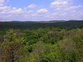
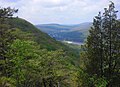
Conyngham Township hugs the eastern bank of the Susquehanna River. According to the United States Census Bureau, the township has a total area of 17.0 square miles (44.0 km2), of which 16.0 square miles (41.4 km2) is land and 0.97 square miles (2.5 km2), or 5.73%, is water. [4] Mocanaqua is a village in the northern half of Conyngham Township (near Shickshinny Borough). The village of Wapwallopen is located in the southernmost section of the township.

Most of Conyngham Township is rural. It is made up of farmland, dense forests, mountains, streams, and lakes (e.g., Lily Lake in eastern Conyngham Township). The only major highway in the township is PA 239, which runs north to south along the Susquehanna River.

Demographics

Historical population
CensusPop.Note
2000 1,385
2010 1,4534.9%
2020 1,309−9.9%
2021 (est.)1,312 [2] 0.2%

At the 2000 census there were 1,385 people, 600 households, and 385 families in the township. The population density was 87.4 inhabitants per square mile (33.7/km2). There were 691 housing units at an average density of 43.6 per square mile (16.8/km2). The racial makeup of the township was 98.19% White, 0.72% Black or African American, 0.58% Asian American, 0.22% from other races, and 0.29% from two or more races. Hispanic or Latino of any race were 0.79%. [5]

There were 600 households, 24.2% had children under the age of 18 living with them, 50.7% were married couples living together, 8.3% had a female householder with no husband present, and 35.7% were non-families. 30.0% of households were made up of individuals, and 17.0% were one person aged 65 or older. The average household size was 2.31 and the average family size was 2.86.

The age distribution was 19.4% under the age of 18, 7.8% from 18 to 24, 28.2% from 25 to 44, 22.8% from 45 to 64, and 21.9% 65 or older. The median age was 41 years. For every 100 females, there were 99.6 males. For every 100 females age 18 and over, there were 91.9 males.

The median household income was $31,667 and the median family income was $38,681. Males had a median income of $29,688 versus $22,917 for females. The per capita income for the township was $16,946. 10.3% of the population and 6.1% of families were below the poverty line. 11.2% are under the age of 18, and 10.1% of those 65 and older were living below the poverty line.

Related Research Articles

<span class="mw-page-title-main">Beaver Township, Columbia County, Pennsylvania</span> Township in Pennsylvania, United States

Beaver Township is a township in Columbia County, Pennsylvania. It is part of Northeastern Pennsylvania. The population was 879 at the 2020 census. Beaver Township is named for Beaver Run, a tributary of Catawissa Creek, both of which run through the township.

<span class="mw-page-title-main">Fishing Creek Township, Columbia County, Pennsylvania</span> Township in Pennsylvania, United States

Fishing Creek Township is a township in Columbia County, Pennsylvania. It is part of Northeastern Pennsylvania. The population was 1,416 at the 2010 census.

<span class="mw-page-title-main">Madison Township, Columbia County, Pennsylvania</span> Township in Pennsylvania, United States

Madison Township is a township in Columbia County, Pennsylvania. It is part of Northeastern Pennsylvania. The population was 1,566 at the 2020 census.

<span class="mw-page-title-main">Sugarloaf Township, Columbia County, Pennsylvania</span> Township in Pennsylvania, United States

Sugarloaf Township is a township in Columbia County, Pennsylvania. It is part of Northeastern Pennsylvania.

<span class="mw-page-title-main">Monroe Township, Juniata County, Pennsylvania</span> Township in Pennsylvania, United States

Monroe Township is a township that is located in Juniata County, Pennsylvania, United States. The population was 2,048 at the time of the 2020 census, a decrease from the figure of 2,237 that was tabulated in 2010.

<span class="mw-page-title-main">Conyngham, Pennsylvania</span> Borough in Pennsylvania, United States

Conyngham is a borough in Luzerne County, Pennsylvania, United States. The population was 1,820 at the 2020 census.

<span class="mw-page-title-main">Dorrance Township, Luzerne County, Pennsylvania</span> Township in Pennsylvania, United States

Dorrance Township is a township in Luzerne County, Pennsylvania, United States. The population was 2,077 at the 2020 census.

<span class="mw-page-title-main">Fairmount Township, Luzerne County, Pennsylvania</span> Township in Pennsylvania, United States

Fairmount Township is a township in Luzerne County, Pennsylvania, United States. The population was 1,207 at the 2020 census. Fairmount Township is home to Ricketts Glen State Park. The park receives tens of thousands of visitors each year.

<span class="mw-page-title-main">Hollenback Township, Luzerne County, Pennsylvania</span> Township in Pennsylvania, United States

Hollenback Township is a township which is located in Luzerne County, Pennsylvania, United States. The population was 1,125 at the time of the 2020 census.

<span class="mw-page-title-main">Hunlock Township, Luzerne County, Pennsylvania</span> Township in Pennsylvania, United States

Hunlock Township is a township in Luzerne County, Pennsylvania, United States. The population was 2,215 at the 2020 census.

<span class="mw-page-title-main">Huntington Township, Luzerne County, Pennsylvania</span> Township in Pennsylvania, United States

Huntington Township is an American township which is in Luzerne County, Pennsylvania. The population was 2,052 at the time of the 2020 census.

<span class="mw-page-title-main">Mountain Top, Pennsylvania</span> Census-designated place in Pennsylvania, United States

Mountain Top is an unincorporated area and census-designated place (CDP) in Luzerne County, Pennsylvania, United States. As of the 2010 census, the CDP population was 10,982.

<span class="mw-page-title-main">Newport Township, Luzerne County, Pennsylvania</span> First Class Township in Pennsylvania, United States

Newport Township is a township in Luzerne County, Pennsylvania, United States. As of 2020, the population was 4,444. Newport is located on the outskirts of Nanticoke City.

<span class="mw-page-title-main">Rice Township, Luzerne County, Pennsylvania</span> Township in Pennsylvania, United States

Rice Township is a township in Luzerne County, Pennsylvania, United States. The population was 3,626 at the 2020 census.

<span class="mw-page-title-main">Salem Township, Luzerne County, Pennsylvania</span> Township in Pennsylvania, United States

Salem Township is a township in Luzerne County, Pennsylvania, United States. The population was 4,019 at the 2020 census. The Susquehanna Steam Electric Station, a nuclear power plant, is located in Salem.

<span class="mw-page-title-main">Shickshinny, Pennsylvania</span> Borough in Pennsylvania, United States

Shickshinny is a borough in Luzerne County, Pennsylvania, United States. The population was 630 at the 2020 census.

<span class="mw-page-title-main">Sugarloaf Township, Luzerne County, Pennsylvania</span> Township in Pennsylvania, United States

Sugarloaf Township is a townshipthat is located in Luzerne County, Pennsylvania, United States. The population was 3,879 at the time of the 2020 census.

<span class="mw-page-title-main">Wright Township, Luzerne County, Pennsylvania</span> Township in Pennsylvania, United States

Wright Township is a township in Luzerne County, Pennsylvania, United States. The population was 5,726 at the 2020 census.

<span class="mw-page-title-main">East Union Township, Schuylkill County, Pennsylvania</span> Township in Pennsylvania, United States

East Union Township is a township in Schuylkill County, Pennsylvania, United States. The population was 1,648 at the 2020 census.

<span class="mw-page-title-main">Gregg Township, Union County, Pennsylvania</span> Township in Pennsylvania, United States

Gregg Township is a township in Union County, Pennsylvania, United States. The population was 4,339 at the 2020 census, of which 3,679 were federal inmates.

References

  1. "2016 U.S. Gazetteer Files". United States Census Bureau. Retrieved August 14, 2017.
  2. 1 2 3 4 Bureau, US Census. "City and Town Population Totals: 2020—2021". Census.gov. US Census Bureau. Retrieved August 3, 2022.
  3. "Conyngham Township".
  4. "Geographic Identifiers: 2010 Demographic Profile Data (G001): Conyngham township, Luzerne County, Pennsylvania". United States Census Bureau . Retrieved April 13, 2012.
  5. "U.S. Census website". United States Census Bureau . Retrieved January 31, 2008.

41°08′00″N76°07′59″W / 41.13333°N 76.13306°W / 41.13333; -76.13306