
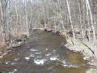
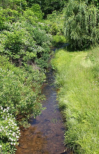
Bowman Creek is a tributary of the Susquehanna River in Luzerne County and Wyoming County, in Pennsylvania, in the United States. It is approximately 26 miles (42 km) long and flows through Ross Township and Lake Township in Luzerne County and Noxen Township, Monroe Township, and Eaton Township in Wyoming County. The watershed of the creek has an area of 120 square miles (310 km2). The creek is not designated as an impaired waterbody and its pH is close to neutral, although it has experienced some problems with acid rain. It has low concentrations of dissolved solids like calcium. The creek is relatively small in its upper reaches, but by Noxen, its width is 40 to 60 feet. It is also relatively shallow in many reaches. Rock formations in the watershed include the Catskill Formation, the Huntley Mountain Formation, Burgoon Sandstone, the Mauch Chunk Formation, the Pottsville Group, and the Pocono Formation. Soil associations in the creek's watershed include the Wellsboro-Morris-Oquaga association, the Oquaga-Lackawanna-Arnot association, the Mardin-Bath-Volusia association, and the Wyoming-Pope association.

Harveys Creek is a tributary of the Susquehanna River in Luzerne County, Pennsylvania, in the United States. It is approximately 14.5 miles (23.3 km) long and flows through Harveys Lake, Lake Township, Lehman Township, Jackson Township, and Plymouth Township. The creek's watershed has an area of 46.3 square miles (120 km2). The creek has four named tributaries, which are known as Bear Hollow Creek, Paint Spring Run, Pikes Creek, and East Fork Harveys Creek. The watershed is designated as a High-Quality Coldwater Fishery and a Migratory Fishery above Pikes Creek and as a Coldwater Fishery and a Migratory Fishery below it. The creek's source is Harveys Lake, the largest natural lake in Pennsylvania.

Big Wapwallopen Creek is a tributary of the Susquehanna River in Luzerne County, Pennsylvania, in the United States. It is approximately 23 miles (37 km) long and flows through Bear Creek Township, Fairview Township, Rice Township, Wright Township, Dorrance Township, Hollenback Township, Nescopeck Township, and Conyngham Township. The watershed of the creek has an area of 53.2 square miles (138 km2). The creek has three named tributaries: Balliet Run, Watering Run, and Bow Creek. The creek is designated as a Coldwater Fishery and a Migratory Fishery and is also Class A Wild Trout Waters for part of its length. However, a portion is considered to be impaired by organic enrichment and/or low levels of dissolved oxygen and its pH ranges from moderately acidic to slightly alkaline.

Roaring Creek is a tributary of the Susquehanna River in Columbia County and Montour County, in Pennsylvania, in the United States. It is slightly more than 20 miles (32 km) long and flows through Roaring Creek Township, Locust Township, Catawissa Township, Cleveland Township, and Franklin Township in Columbia County and Mayberry Township in Montour County. The watershed of the creek has an area of 87.3 square miles (226 km2). It has three named tributaries: South Branch Roaring Creek, Lick Run, and Mill Creek. The creek is not considered to be impaired and is not affected by coal mining. However, its watershed has been impacted by human land use. Claystones, conglomerates, sandstones, siltstones, and shales all occur within the watershed. The creek flows through a gorge in its lower reaches, along the border between Columbia County and Montour County.
Little Wapwallopen Creek is a tributary of the Susquehanna River in Luzerne County, Pennsylvania, in the United States. It is approximately 17 miles (27 km) long and flows through Rice Township, Dorrance Township, Conyngham Township, and Hollenback Township. The watershed of the creek has an area of 39.5 square miles (102 km2). The creek is designated as a Coldwater Fishery and a Migratory Fishery and is not considered to be impaired. It has two named tributaries: Pond Creek and Nuangola Outlet. Wild trout naturally reproduce in the creek.

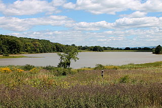
Lake Chillisquaque is a lake and reservoir in Montour County, Pennsylvania, in the United States. It has a surface area of 165 acres. The lake is situated on Middle Branch Chillisquaque Creek, which it is named after. Nearby communities include Danville and Washingtonville. The lake has an elevation of 567 feet (173 m) above sea level and is up to 40 feet (12 m) deep. It has several coves, including Goose Cove, Heron Cove, and Jellyfish Cove. The lake is dammed on its southern side by the Lake Chillisquaque Dam, which is 2,000 feet (610 m) long and 54 feet (16 m) high. The metals with the highest concentrations are calcium and iron. Nonmetals such as nitrogen and phosphorus are also found in the lake. It experiences agricultural runoff as well.
Scotch Run is one of the main tributaries of Catawissa Creek in Columbia County, Pennsylvania, in the United States. It is approximately 7.8 miles (12.6 km) long and flows through Beaver Township and Main Township. The stream's watershed has an area of 9.10 square miles (23.6 km2). The stream is infertile and acidic. It is 7.2 feet (2.2 m) wide in its upper reaches and 17.0 feet (5.2 m) wide in its lower reaches. The main rock formations in the watershed include the Mauch Chunk Formation, the Pocono Formation, the Pottsville Formation, and the Spechty Kopf Formation. The main soils include Leck Kill soil and Hazleton soil. It flows between Nescopeck Mountain and McCauley Mountain.

Raccoon Creek is a tributary of Tomhicken Creek in Luzerne County and Schuylkill County, in Pennsylvania, in the United States. It is approximately 3.3 miles (5.3 km) long and flows through Black Creek Township in Luzerne County and North Union Township in Schuylkill County. The watershed of the stream has an area of 2.67 square miles (6.9 km2). The stream is considered to be a High-Quality Coldwater Fishery and Class A Wild Trout Waters. The main rock formations in the stream's watershed are the Mauch Chunk Formation and the Pottsville Formation and the main soil is the Leck Kill soil.
Phillips Creek is a tributary of Huntington Creek in Luzerne County, Pennsylvania, in the United States. It is approximately 5.3 miles (8.5 km) long and flows through Fairmount Township. The watershed of the creek has an area of 5.54 square miles (14.3 km2) and has no named tributaries. The creek is considered by the Pennsylvania Fish and Boat Commission to be Class A Wild Trout Waters for brook trout throughout its entire length. Glacial till, alluvium, sandstone, and shale can be found in its vicinity. Its course has been altered by glaciation and it is in the vicinity of North Mountain. At least one bridge has been built over the creek and a number of hunting cabins and cottages existed in the area. The creek's discharge has a 10 percent chance of reaching 915 cubic feet per second in any given year.
The Briar Creek Reservoir is a reservoir in Columbia County, Pennsylvania, in the United States. It has an area of 51.04 acres and is located in Briar Creek Township. The lake is situated on East Branch Briar Creek. The lake was constructed in the early 1970s for the purpose of flood control. It is dammed by the Briar Creek Dam. Shale and limestone rocks are found in the lake's vicinity. The lake was electrofished by the Pennsylvania Fish and Boat Commission in 2010. The reservoir is designated as Approved Trout Waters and is stocked with trout. More than a dozen species of fish inhabit it and several bird species are found in its vicinity. The lake is part of the 173-acre Briar Creek Lake Park. Fishing and boating are done in the reservoir.

Pond Creek is a tributary of Little Wapwallopen Creek in Luzerne County, Pennsylvania, in the United States. It is approximately 6.4 miles (10.3 km) long and flows through Slocum Township and Conyngham Township. The watershed of the creek has an area of 9.69 square miles (25.1 km2) and is part of the Lower North Branch Susquehanna drainage basin. A bridge was built over the creek in 1956. In the early 1900s, the Glen Brook Water Company planned to construct a dam on the creek. The surficial geology in the vicinity of Pond Creek includes Wisconsinan Till, alluvium, boulder alluvium, alluvial fan, and bedrock consisting of sandstone and shale, as well as some patches of wetland.

Roaring Brook is a tributary of Hunlock Creek in Luzerne County, Pennsylvania, in the United States. It is approximately 5.0 miles (8.0 km) long and flows through Ross Township and Hunlock Township. The watershed of the stream has an area of 6.17 square miles (16.0 km2). It has one named tributary, which is known as Lewis Run. Additionally, a dammed pond known as Harris Pond is located at the stream's headwaters. The Roaring Brook Swamp, which is listed as a Locally Significant Area on the Luzerne County Natural Areas Inventory, is also located in the watershed.

Pikes Creek is a tributary of Harveys Creek in Luzerne County, Pennsylvania, in the United States. It is approximately 8.9 miles (14.3 km) long and flows through Lake Township, Lehman Township, Jackson Township, and Plymouth Township. The watershed of the creek has an area of 11.6 square miles (30 km2). It is designated as a High-Quality Coldwater Fishery and a Migratory Fishery, as well as being Class A Wild Trout Waters for part of its length. The creek has a 400-acre reservoir, which is known as the Pikes Creek Reservoir and supplies water to tens of thousands of people. A number of bridges have been constructed over the creek.
Fades Creek is a tributary of Pikes Creek in Luzerne County, Pennsylvania, in the United States. It is approximately 3.2 miles (5.1 km) long and flows through Lake Township. The watershed of the creek has an area of 2.07 square miles (5.4 km2). It has one unnamed tributary and is designated as a High-Quality Coldwater Fishery and Class A Wild Trout Waters for part of its length. The creek is crossed by a pipeline and a bridge carrying Pennsylvania Route 118. Wisconsinan Ice-Intact Stratified Drift, alluvium, Wisconsinan Till, Wisconsinan Bouldery Till, and bedrock consisting of sandstone and shale all occur in the surficial geology in the creek's vicinity.

Harveys Lake is a natural lake in Luzerne County, Pennsylvania. It has a surface area of approximately 621.5 acres, or nearly a square mile. The lake is situated entirely within the borough of Harveys Lake. By volume, it is the largest natural lake in Pennsylvania, and by surface area, is the second-largest lake. It is a glacial lake surrounded by hills and is the source of Harveys Creek, a tributary of the Susquehanna River. The lake has a stone masonry dam. The lake's watershed has an area of approximately 3600 acres. The majority of the watershed is forested, but there is some developed land as well. Nearly all of the developed land is close to the lake itself, and the lake is surrounded entirely by a paved road.

Lake Jean is a lake in Luzerne County and Sullivan County, in Pennsylvania, in the United States. It has a surface area of approximately 245 acres (99 ha) and is situated in Colley Township, Sullivan County and Fairmount Township, Luzerne County. The lake's main inflow is the outlet of Ganoga Lake. Lake Jean is fairly shallow, with an average depth of 5.9 feet (1.8 m). It is in the watershed of Fishing Creek. The main rock formations in the lake's watershed include Burgoon Sandstone and the Mauch Chunk Formation. The lake is dammed by the Lake Jean Dam and is owned by the Pennsylvania Department of Conservation and Natural Resources.
Lewis Creek is a tributary of the Susquehanna River in Luzerne County, Pennsylvania, in the United States. It is approximately 1.8 miles (2.9 km) long and flows through Exeter Township. The watershed of the creek has an area of 1.64 square miles (4.2 km2). The creek is not designated as impaired and has typical water chemistry for a stream of its geology and land use. Rock formations in its watershed include the Catskill Formation.
Sutton Creek is a tributary of the Susquehanna River in Luzerne County, Pennsylvania, in the United States. It is approximately 7.6 miles (12.2 km) long and flows through Dallas Township, Franklin Township, and Exeter Township. The watershed of the creek has an area of 11.6 square miles (30 km2). The creek has one named tributary, which is known as Cider Run. Sutton Creek is located a few miles upriver of the Wyoming Valley. The surficial geology in its watershed consists of alluvium, Wisconsinan Till, Wisconsinan Ice-Contact Stratified Drift, and bedrock, while the bedrock geology consists of sandstone.

Sorber Run is a tributary of Bowman Creek in Luzerne County and Wyoming County, in Pennsylvania, in the United States. It is approximately 3.1 miles (5.0 km) long and flows through Lake Township in Luzerne County and Noxen Township in Wyoming County. The watershed of the stream has an area of 2.08 square miles (5.4 km2). The surficial geology in the stream's vicinity consists of alluvium and Wisconsinan Till. The watershed is designated as Exceptional Value waters and a Migratory Fishery. The stream is one of two Wilderness Trout Streams in Wyoming County.
Pikes Creek Reservoir is a reservoir in Luzerne County, Pennsylvania, in the United States. It has a surface area of approximately 400 acres (160 ha) and is situated in Lehman Township, Jackson Township, and Plymouth Township. The lake is situated on Pikes Creek. It has a volume of approximately 3 billion gallons and is used as a water supply reservoir. As of 2013, it is inhabited by fifteen fish species. The reservoir is owned by the Pennsylvania-American Water Company, but shoreline fishing is permitted at designated spots.


