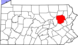
Trucksville, Pennsylvania | |
---|---|
Coordinates: 41°18′14″N75°55′55″W / 41.30389°N 75.93194°W Coordinates: 41°18′14″N75°55′55″W / 41.30389°N 75.93194°W | |
Country | United States |
State | Pennsylvania |
County | Luzerne |
Township | Kingston |
Area | |
• Total | 1.7 sq mi (4.5 km2) |
• Land | 1.7 sq mi (4.5 km2) |
• Water | 0 sq mi (0 km2) |
Population (2010) | |
• Total | 2,152 |
• Density | 1,200/sq mi (480/km2) |
Time zone | UTC-5 (Eastern (EST)) |
• Summer (DST) | UTC-4 (EDT) |
ZIP code | 18708 |
Area code | 570 |
Trucksville is a census-designated place (CDP) in Kingston Township, Luzerne County, Pennsylvania, United States. The population was 2,152 at the 2010 census. [1]
Trucksville is located at 41°18′14″N75°55′55″W / 41.30389°N 75.93194°W , [2] along Pennsylvania Route 309 in the western part of Kingston Township. It is located directly south of the CDP of Shavertown and 3 miles (5 km) north of the borough of Kingston. Trucksville is served by the Shavertown post office, with the zip code of 18708.
According to the United States Census Bureau, the CDP has a total area of 1.7 square miles (4.5 km2), all land. [3]
The village is the site of the Lands at Hillside Farms, a popular small dairy store planned to expand into a major U.S. attraction the likes of Williamsburg, Virginia. The town has a volunteer fire department, a Methodist church, and a popular pizza place established in 1975. Trucksville is named for the town's founder, William Trucks (Trux), who operated a sawmill in the 19th century.
Crown Heights is a hamlet and census-designated place (CDP) in Dutchess County, New York, United States. The population was 2,840 at the 2010 census. It is part of the Poughkeepsie–Newburgh–Middletown, NY Metropolitan Statistical Area as well as the larger New York–Newark–Bridgeport, NY-NJ-CT-PA Combined Statistical Area.
Kingston Township is a township in Luzerne County, Pennsylvania, United States. The population was 7,096 at the 2020 census. The villages of Trucksville and Shavertown are located within the township. It is home to Frances Slocum State Park. The township is described as "the gateway to the Back Mountain". The area includes the townships of Dallas, Franklin, Jackson, Kingston, Lake, and Lehman. The region also includes the boroughs of Dallas and Harveys Lake.
Devon is a census-designated place (CDP) located in Tredyffrin and Easttown Township, Chester County, Pennsylvania. The population was 1,515 at the 2010 census. The area is part of the Philadelphia Main Line suburbs.
Shavertown is a census-designated place (CDP) in Kingston Township, Luzerne County, Pennsylvania, United States. It lies approximately 7 miles (11 km) northwest of the city of Wilkes-Barre and 24 miles (39 km) southwest of Scranton. The population of the CDP was 2,019 at the 2010 census.
Pardeesville is a census-designated place (CDP) in Hazle Township, Luzerne County, Pennsylvania, United States. The population was 572 at the 2010 census.
Sheatown is a census-designated place (CDP) in Newport Township, Luzerne County, Pennsylvania, United States. It is adjacent to the west side of the city of Nanticoke. The population of Sheatown was 671 at the 2010 census.
West Nanticoke is a census-designated place (CDP) in Plymouth Township, Luzerne County, Pennsylvania, United States, across the Susquehanna River from the city of Nanticoke. The population of the CDP was 749 at the 2010 census.
Cochranville is a census-designated place (CDP) in West Fallowfield Township, Chester County, Pennsylvania, United States. The population was 668 at the 2010 census. It is the hometown of Olympic swimmer Cierra Runge.
Plains is a census-designated place (CDP) in Plains Township, Luzerne County, Pennsylvania, United States. The population of the CDP was 4,335 at the 2010 census, out of 9,961 in the entire township.
Inkerman is a census-designated place (CDP) in Jenkins Township, Luzerne County, Pennsylvania, United States. The population was 1,819 at the 2010 census.
Chase is a census-designated place (CDP) in Jackson Township, Luzerne County, Pennsylvania, United States. The CDP population was 978 at the 2010 census.
Georgetown is a census-designated place (CDP) in Wilkes-Barre Township, Luzerne County, Pennsylvania, United States, adjacent to the city of Wilkes-Barre. The CDP population was 1,640 at the 2010 census.
Hickory Hills is a census-designated place (CDP) in Foster Township, Luzerne County, Pennsylvania, southwest of the borough of White Haven. The CDP population was 562 at the 2010 census.
Hilldale is a census-designated place (CDP) in Plains Township, Luzerne County, Pennsylvania, United States. The population was 1,246 at the 2010 census.
Hudson is a census-designated place (CDP) in Plains Township, Luzerne County, Pennsylvania, United States. The population was 1,443 at the 2010 census.
Pikes Creek is a census-designated place (CDP) in Lake Township, Luzerne County, Pennsylvania, United States. The population was 269 at the 2010 census.
Upper Exeter is a census-designated place (CDP) in Exeter Township, Luzerne County, Pennsylvania, United States. The population was 707 at the 2010 census.
Caln is a census-designated place (CDP) in Caln Township, Chester County, Pennsylvania, United States. The population was 1,519 at the 2010 census. It is located east of the city of Coatesville and lies west of Philadelphia.
Pomeroy is a census-designated place (CDP) in Sadsbury Township, Chester County, Pennsylvania, United States. The population was 401 at the 2010 census.
Westwood is a census-designated place (CDP) in Valley Township, Chester County, Pennsylvania, United States. The population was 950 at the 2010 census.