Harleigh, Pennsylvania

Last updated

Harleigh, Pennsylvania
PA 940 wb in Harleigh (1), July 2023.jpg
Looking west along PA 940
USA Pennsylvania location map.svg
Red pog.svg
Harleigh
Location in Pennsylvania
Usa edcp location map.svg
Red pog.svg
Harleigh
Location in the United States
Coordinates: 40°59′0″N75°58′20″W / 40.98333°N 75.97222°W / 40.98333; -75.97222
Country United States
State Pennsylvania
County Luzerne
Township Hazle
Area
[1]
  Total
0.57 sq mi (1.48 km2)
  Land0.57 sq mi (1.48 km2)
  Water0.00 sq mi (0.00 km2)
Population
 (2020) [2]
  Total
1,050
  Density1,835.66/sq mi (708.26/km2)
Time zone UTC-5 (Eastern (EST))
  Summer (DST) UTC-4 (EDT)
ZIP code
18225
Area code(s) 570 and 272
FIPS code 42-32600

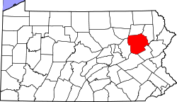
Harleigh is a census-designated place (CDP) in Hazle Township, Luzerne County, Pennsylvania, United States, north of the city of Hazleton. The CDP population was 1,104 at the 2010 census. [3]

Contents

Geography

Harleigh is located at 40°59′0″N75°58′20″W / 40.98333°N 75.97222°W / 40.98333; -75.97222 . [4]

According to the United States Census Bureau, the CDP has a total area of 0.58 square miles (1.5 km2), all land. Harleigh is located less than one mile north of the city of Hazleton, along PA 940 (an east-west road). The western terminus of PA 940 is located just west of Harleigh at PA 309 (a north-south highway); it connects Hazleton (to the south) with Mountain Top and Wilkes-Barre (to the north).

Demographics

Historical population
CensusPop.Note
2020 1,050
U.S. Decennial Census [5]

The 2020 United States census gave the population as 1050 people. [5]

Education

The school district is the Hazleton Area School District. [6]

References

  1. "ArcGIS REST Services Directory". United States Census Bureau. Retrieved October 12, 2022.
  2. "Census Population API". United States Census Bureau. Retrieved October 12, 2022.
  3. "Profile of General Population and Housing Characteristics: 2010 Demographic Profile Data (DP-1): Harleigh CDP, Pennsylvania". United States Census Bureau . Retrieved April 20, 2012.
  4. "US Gazetteer files: 2010, 2000, and 1990". United States Census Bureau. February 12, 2011. Retrieved April 23, 2011.
  5. 1 2 "Census of Population and Housing". Census.gov. Retrieved June 4, 2016.
  6. "2020 CENSUS - SCHOOL DISTRICT REFERENCE MAP: Luzerne County, PA" (PDF). U.S. Census Bureau . Retrieved December 13, 2024. - Text list