Pittston Area School District

Last updated
Pittston Area School District
Map of Luzerne County Pennsylvania School Districts.png
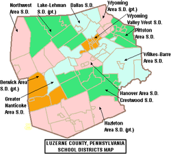
Map of Luzerne County, Pennsylvania school districts, with the Pittston Area School District in green in the north-eastern part of the county
Address
1337 Stout Street
Pittston
, Pennsylvania, 18640
United States
Coordinates 41°19′34″N75°44′10″W / 41.3261°N 75.7361°W / 41.3261; -75.7361
District information
TypePublic
Established1966
Other information
Website http://pittstonarea.com/index.php

Pittston Area School District (PASD) is a mid-sized school district located in the Greater Pittston area of Luzerne County, Pennsylvania, the north-eastern part of the state, in the United States. The school district serves students from the city of Pittston, the boroughs of Avoca, Dupont, Duryea, Hughestown, Yatesville, Jenkins, and Pittston townships. Pittston Area School District encompasses approximately 42 square miles. According to 2000 federal census data, it serves a resident population of 30,034. In 2019, the residents' per capita income was $16,811 and the median family income was $40,063. [1] Per school district officials, in school year 2005–06, the PASD provided basic educational services to 3,147 pupils through the employment of 196 teachers, 159 full-time and part-time support personnel, and 10 administrators.

Contents

PASD was created in 1969 by merging Pittston School District, Pittston Township School District, Hughestown School District, Dupont School District, Duryea School District, and Avoca School District. The first superintendent was Martin Mattei. PASD currently runs four schools: Pittston Area Senior High School in Yatesville (grades 9 through 12), Martin L. Mattei Middle School in Pittston (grades 5 through 8), Pittston Area Intermediate Center in Pittston (grades 2 through 4), Pittston Area Primary School in Hughestown (Kindergarten and first grades).

Notable alumni

Related Research Articles

<span class="mw-page-title-main">Luzerne County, Pennsylvania</span> County in Pennsylvania, United States

Luzerne County is a county in the Commonwealth of Pennsylvania. According to the United States Census Bureau, the county has a total area of 906 square miles (2,350 km2), of which 890 square miles (2,300 km2) is land and 16 square miles (41 km2) is water. It is Northeastern Pennsylvania's second-largest county by total area. As of the 2020 census, the population was 325,594, making it the most populous county in the northeastern part of the state. The county seat and largest city is Wilkes-Barre. Other populous communities include Hazleton, Kingston, Nanticoke, and Pittston. Luzerne County is included in the Scranton–Wilkes-Barre–Hazleton Metropolitan Statistical Area, which has a total population of 555,426 as of 2017.

<span class="mw-page-title-main">Northfield, Illinois</span> Village in Illinois, United States

Northfield is a village in Cook County, Illinois, United States, located approximately 19 miles (31 km) north of downtown Chicago. As of the 2020 census, the village's population was 5,751. It is part of a collection of upscale residential communities north of Chicago that belong to New Trier and Northfield Townships and the greater North Shore.

<span class="mw-page-title-main">Avoca, Pennsylvania</span> Borough in Pennsylvania, United States

Avoca is a borough within the Greater Pittston area of Luzerne County, Pennsylvania, United States. It is located 7.5 miles (12.1 km) northeast of Wilkes Barre and 3.4 miles (5.5 km) southwest of Scranton. The population was 2,501 at the time of the 2020 census. The Wilkes-Barre/Scranton International Airport (AVP) is located near Avoca.

<span class="mw-page-title-main">Duryea, Pennsylvania</span> Borough in Pennsylvania, United States

Duryea is a borough in the Greater Pittston area of Luzerne County, Pennsylvania, United States, 9 miles (14 km) south of Scranton. The Susquehanna River marks Duryea's western boundary and the Lackawanna River flows through Duryea. It was incorporated as a borough in 1901, and had a notable switching rail yard, the Duryea yard, connecting the central Wyoming Valley to destinations in lower New York and down-state Pennsylvania. Coal mining and silk manufacturing were the chief industries in Duryea's early years. The population was 5,032 at the 2020 census.

<span class="mw-page-title-main">Hughestown, Pennsylvania</span> Borough in Pennsylvania, United States

Hughestown is a borough in the Greater Pittston area of Luzerne County, Pennsylvania, United States. The population was 1,326 at the 2020 census.

<span class="mw-page-title-main">Jenkins Township, Luzerne County, Pennsylvania</span> Township in Pennsylvania, United States

Jenkins Township is a township in the Greater Pittston area of Luzerne County, Pennsylvania, United States. The population was 4,282 at the 2020 census.

<span class="mw-page-title-main">Pittston, Pennsylvania</span> City in Pennsylvania, United States

Pittston is a city in Luzerne County, Pennsylvania, United States. It is situated between Scranton and Wilkes-Barre in Northeastern Pennsylvania. The city gained prominence in the late 19th and early 20th centuries as an active anthracite coal mining city, drawing a large portion of its labor force from European immigrants. The population was 7,591 as of the 2020 census, making it the fourth largest city in Luzerne County.

<span class="mw-page-title-main">Pittston Township, Luzerne County, Pennsylvania</span> Township in Pennsylvania, United States

Pittston Township is a township in Luzerne County, Pennsylvania. The population was 3,179 as of the 2020 census. The township is located within the Greater Pittston region. As of 2010, the total population of Greater Pittston was 48,020. The Wilkes-Barre/Scranton International Airport is located in Pittston Township.

<span class="mw-page-title-main">West Wyoming, Pennsylvania</span> Borough in Pennsylvania, United States

West Wyoming is a borough that is located in Luzerne County, Pennsylvania, United States. The borough is part of the Greater Pittston metro area.

<span class="mw-page-title-main">Yatesville, Pennsylvania</span> Borough in Pennsylvania, United States

Yatesville is a borough in the Greater Pittston area of Luzerne County, Pennsylvania. The population was 638 as of the 2020 census.

<span class="mw-page-title-main">Wyoming Area School District</span> Pennsylvania public school district

The Wyoming Area School District is a midsized, suburban, public school district that is located in northeastern Luzerne County and southeastern Wyoming County, Pennsylvania. It is situated midway between Wilkes-Barre and Scranton (USA).

<span class="mw-page-title-main">Greater Pittston</span> Region in Pennsylvania, United States

Greater Pittston is a 65.35 sq mi (169.3 km2) region in Luzerne County, Pennsylvania, in reference to the area in and around Pittston. As of 2010, the total population of Greater Pittston is 48,020. This region includes Avoca, Dupont, Duryea, Exeter Boro, Exeter Township, Hughestown, Jenkins Township, Laflin, Pittston Township, West Pittston, West Wyoming, Wyoming, and Yatesville.

The Lehigh Division is a major freight low grade rail line owned and operated by the Reading Blue Mountain and Northern Railroad in the U.S. state of Pennsylvania that runs from Lehighton, Pennsylvania to Dupont, Pennsylvania; it originally ran from Lehighton to Mehoopany, Pennsylvania. The Lehigh Division was formed in 1993 by Conrail from the Lehigh Line, officially the former main line of the Lehigh Valley Railroad (LVRR) that has absorbed former Central Railroad of New Jersey (CNJ) main line trackage and former Lehigh and Susquehanna Railroad (L&S) main line trackage into its system under Conrail; the Lehigh Line today is owned by the Norfolk Southern Railway and connects to the Lehigh Division at Lehighton.

<span class="mw-page-title-main">Southern Columbia Area School District</span> School district in Pennsylvania, U.S.

Southern Columbia Area School District is a small, rural, public school district located in Catawissa, Pennsylvania. It serves communities in two counties. In Columbia County the district serves: Catawissa Borough, Catawissa Township, Locust Township, Roaring Creek Township, Franklin Township and Cleveland Township. In Northumberland County it serves Ralpho Township. Southern Columbia Area School District encompasses approximately 108 square miles (280 km2). According to 2000 federal census data, it serves a resident population of 9,803. By 2010, the US Census Bureau reported that the district's population increased to 10,386 people. The per capita income of residents was $18,969 in 2009, while the median family income was $45,889. In the Commonwealth, the median family income was $49,501 and the United States median family income was $49,445, in 2010. The district is one of the 500 public school districts of Pennsylvania.

Pennsylvania State Senate District 22 includes parts of Lackawanna County and Luzerne County. It is currently represented by Democrat Marty Flynn.

<span class="mw-page-title-main">Smethport Area School District</span> School district in Pennsylvania

Smethport Area School District is a rural, public school district located in McKean County, Pennsylvania, United States. Situated in the north central part of the state, it overlooks the borough of Smethport, which serves as the county seat.

<span class="mw-page-title-main">Pennsylvania House of Representatives, District 118</span> American legislative district

The 118th Pennsylvania House of Representatives District is located in Lackawanna County and Luzerne County. The 118th district includes the following areas:

<span class="mw-page-title-main">Punxsutawney Area School District</span> School district in Pennsylvania

The Punxsutawney Area School District (PASD) is a midsized, rural/suburban public school district located in Jefferson County, Pennsylvania and Indiana County, Pennsylvania. The Punxsutawney Area School District encompasses approximately 295 square miles (760 km2). The townships of Banks and North Mahoning as well as a portion of Canoe Township are part of the district's boundaries in Indiana County. Jefferson County boroughs, including Punxsutawney, Worthville, Big Run, and Timblin, are served by the district as well. The townships of Bell, Gaskill, Young, Perry, Porter, Ringgold, Olver, McCalmont, and Henderson are also part of the district. According to the 2000 federal census data, the PASD serves a resident population of 22,055 people.

Browntown is a census-designated place (CDP) in Pittston Township, Luzerne County, Pennsylvania, United States, adjacent to Pittston City. The CDP population was 1,418 at the 2010 census.

Mill Creek is a tributary of the Lackawanna River in Luzerne County and Lackawanna County, in Pennsylvania, in the United States. It is approximately 5.5 miles (8.9 km) long and flows through Pittston Township, Dupont, Avoca, and Duryea in Luzerne County and Moosic in Lackawanna County. The watershed of the creek has an area of 10.6 square miles (27 km2). It is designated as a Coldwater Fishery and a Migratory Fishery. The creek has two named tributaries: Collins Creek and Lidy Creek. The surficial geology in its vicinity includes urban land, coal dumps, surface mining land, Wisconsinan Ice-Contact Stratified Drift, Wisconsinan Till, and bedrock.

References

  1. American Fact Finder, US Census Bureau, 2010
  2. "Home Teams Online", Accessed March 31, 2011.