Welcome sign

Last updated
A welcome sign in Medford, Oregon Welcome to medford oregon.jpg
A welcome sign in Medford, Oregon

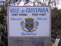
A welcome sign (or gateway sign) is a road sign at the border of a jurisdiction or region that introduces or welcomes visitors to the city/county/state/province/prefecture/canton/region. [1] Examples of welcome signs can be found near political borders, such as when entering a state, province, county, city, or town, and they are increasingly found in neighborhoods and private communities. [2] In European countries under the Schengen Agreement, a welcome sign may be found at borders between countries. Its purpose is partly informational, to inform drivers where they are, and partly for tourism, as it affords an opportunity to advertise features within the region to people who are entering it. A welcome sign is a type of town sign—a sign placed at the entrance to and exit from a city, town, or village. In many jurisdictions, the format of town signs is standardized; in some, welcome signs may be distinct from the legally mandated town sign.

Contents

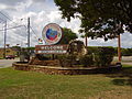
A municipality's welcome sign may give its population or date of foundation, list twinned towns or services within the town, or depict the town's crest, typical local products, or the logo of sponsor organizations which maintain the sign (such as the local Lions Club).

Related Research Articles

<span class="mw-page-title-main">Lesser Poland Voivodeship</span> Province of Poland

Lesser Poland Voivodeship is a voivodeship (province) in southern Poland. It has an area of 15,108 square kilometres (5,833 sq mi), and a population of 3,404,863 (2019).

<span class="mw-page-title-main">Twin cities</span> Neighboring cities that become a conurbation

Twin cities are a special case of two neighboring cities or urban centres that grow into a single conurbation – or narrowly separated urban areas – over time. There are no formal criteria, but twin cities are generally comparable in status and size, though not necessarily equal; a city and a substantially smaller suburb would not typically qualify, even if they were once separate. Tri-cities and quad cities are similar phenomena involving three or four municipalities.

A county is a geographic region of a country used for administrative or other purposes in some nations. The term is derived from the Old French comté denoting a jurisdiction under the sovereignty of a count (earl) or a viscount. Literal equivalents in other languages, derived from the equivalent of "count", are now seldom used officially, including comté, contea, contado, comtat, condado, Grafschaft, graafschap, and zhupa in Slavic languages; terms equivalent to 'commune' or 'community' are now often instead used.

<span class="mw-page-title-main">Las Vegas</span> Largest city in Nevada, United States

Las Vegas, often known simply as Vegas, is the most populous city in the U.S. state of Nevada and the county seat of Clark County. The Las Vegas Valley metropolitan area is the largest within the greater Mojave Desert, and second-largest in the Southwestern United States. Las Vegas is an internationally renowned major resort city, known primarily for its gambling, shopping, fine dining, entertainment, and nightlife, with most venues centered on downtown Las Vegas and more to the Las Vegas Strip just outside city limits. The Las Vegas Valley as a whole serves as the leading financial, commercial, and cultural center for Nevada. According to the United States Census Bureau, the city had 641,903 residents in 2020, with a metropolitan population of 2,227,053, making it the 25th-most populous city in the United States.

In geography, regions, otherwise referred to as areas, zones, lands or territories, are portions of the Earth's surface that are broadly divided by physical characteristics, human impact characteristics, and the interaction of humanity and the environment. Geographic regions and sub-regions are mostly described by their imprecisely defined, and sometimes transitory boundaries, except in human geography, where jurisdiction areas such as national borders are defined in law. More confined or well bounded portions are called locations or places.

<span class="mw-page-title-main">West Pomeranian Voivodeship</span> Voivodeship of Poland

West Pomeranian Voivodeship is a voivodeship (province) in northwestern Poland. Its capital and largest city is Szczecin. Its area equals 22 892.48 km2, and in 2021, it was inhabited by 1,682,003 people.

<span class="mw-page-title-main">Lublin Voivodeship</span> Voivodeship of Poland

Lublin Voivodeship is a voivodeship (province) of Poland, located in the southeastern part of the country. It was created on January 1, 1999, out of the former Lublin, Chełm, Zamość, Biała Podlaska and (partially) Tarnobrzeg and Siedlce Voivodeships, pursuant to Polish local government reforms adopted in 1998. The region is named after its largest city and regional capital, Lublin, and its territory is made of four historical lands: the western part of the voivodeship, with Lublin itself, belongs to Lesser Poland, the eastern part of Lublin Area belongs to Red Ruthenia, and the northeast belongs to Polesie and Podlasie. Lublin Voivodeship borders Subcarpathian Voivodeship to the south, Świętokrzyskie Voivodeship to the south-west, Masovian Voivodeship to the west and north, Podlaskie Voivodeship along a short boundary to the north, Belarus and Ukraine to the east. The region's population as of 2019 was 2,112,216. It covers an area of 25,155 square kilometres (9,712 sq mi).

<span class="mw-page-title-main">Subcarpathian Voivodeship</span> Voivodeship of Poland

Subcarpathian Voivodeship is a voivodeship, or province, in the southeastern corner of Poland. Its administrative capital and largest city is Rzeszów. Along with the Marshal, it is governed by the Subcarpathian Regional Assembly. Historically, most of the province's territory was part of the Kingdom of Galicia–Volhynia, the Kingdom of Galicia and Lodomeria and the Ruthenian Voivodeship. In the interwar period, it was part of the Lwów Voivodeship.

<span class="mw-page-title-main">Podlachia</span> Historical region in northeastern Poland

Podlachia, or Podlasie (Polish), is a historical region in the north-eastern part of Poland. Between 1513 and 1795 it was a voivodeship with the capital in Drohiczyn. Now the part north of the Bug River is included in the modern Podlaskie Voivodeship with the capital in Białystok.

<span class="mw-page-title-main">Revanchism</span> Will to recapture a lost territory

Revanchism is the political manifestation of the will to reverse the territorial losses which are incurred by a country, frequently after a war or after a social movement. As a term, revanchism originated in 1870s France in the aftermath of the Franco-Prussian War among nationalists who wanted to avenge the French defeat and reclaim the lost territories of Alsace-Lorraine.

<span class="mw-page-title-main">Eastern European Time</span> Time zone in Eastern Europe (GMT +2)

Eastern European Time (EET) is one of the names of UTC+02:00 time zone, 2 hours ahead of Coordinated Universal Time. The zone uses daylight saving time, so that it uses UTC+03:00 during the summer.

<span class="mw-page-title-main">Tauragė</span> City in Samogitia, Lithuania

Tauragė is an industrial city in Lithuania, and the capital of Tauragė County. In 2020, its population was 21,520. Tauragė is situated on the Jūra River, close to the border with the Kaliningrad Oblast, and not far from the Baltic Sea coast.

<span class="mw-page-title-main">Zhytomyr Oblast</span> Province of Ukraine

Zhytomyr Oblast, also referred to as Zhytomyrshchyna, is an oblast (province) in northern Ukraine. The administrative center of the oblast is the city of Zhytomyr. Its population is approximately 1,179,032.

<span class="mw-page-title-main">Welcome to Fabulous Las Vegas sign</span> United States historic place

The Welcome to Fabulous Las Vegas sign is a Las Vegas landmark funded in May 1959 and erected soon after by Western Neon. The sign was designed by Betty Willis at the request of Ted Rogich, a local salesman, who sold it to Clark County, Nevada.

<span class="mw-page-title-main">Huludao</span> Prefecture-level city in Liaoning, Peoples Republic of China

Huludao, formerly known as Jinxi (锦西) until 1994, is a coastal prefecture-level city in southwestern Liaoning province, People's Republic of China. Its name literally means "Gourd Island", referring to the fiddle-shaped contour of the peninsula, which resembles a bottle gourd, at the city's Longgang District. It has a total area of 10,582 km2 (4,086 sq mi) and as of the 2020 census a population of 2,434,194 of whom 1,252,660 inhabitants lived in the built-up area made of the 2 urban districts and Xingcheng City largely being conurbated.

<span class="mw-page-title-main">Bilingual sign</span> Sign with text in more than one language

A bilingual sign is the representation on a panel of texts in more than one language. The use of bilingual signs is usually reserved for situations where there is legally administered bilingualism or where there is a relevant tourist or commercial interest. However, more informal uses of bilingual signs are often found on businesses in areas where there is a high degree of bilingualism, such as tourist venues, ethnic enclaves and historic neighborhoods. In addition, some signs feature synchronic digraphia, the use of multiple writing systems for a single language.

A town sign or city limit sign is a road sign placed at the side of the road or street at the boundary of the territory of a city, town, or village. Town signs may be placed for reading both by drivers entering the town and, in a different format, by those exiting it. Signs give the name of the town in the local official languages, and sometimes in other languages. In some countries, town signs are also an essential part of the traffic law, for example by defining the speed limit within the town's territory. In some countries, such as Germany and Austria, signs aren't placed at the exact boundary of a city or town, but rather at the location where the settlement's built-up area begins and ends.

<span class="mw-page-title-main">Linguistic landscape</span> Language on public signs

The linguistic landscape refers to the "visibility and salience of languages on public and commercial signs in a given territory or region". Linguistic landscape research has been described as being "somewhere at the junction of sociolinguistics, sociology, social psychology, geography, and media studies". It is a concept which originated in sociolinguistics and language policy as scholars studied how languages are visually displayed and hierarchised in multilingual societies, from large metropolitan centers to Amazonia. For example, linguistic landscape scholars have described how and why some public signs in Jerusalem are presented in Hebrew, English, and Arabic, or a combination thereof. It also looks at how communication in public space plays a crucial role in the organisation of society.

References

  1. "Discussion Documents - Class 4F - Gateway Signs" (PDF). South African Manual for Outdoor Advertising. South African Dept. of Environmental Affairs and Tourism. Retrieved 2009-04-13.
  2. McGee, David (11 April 2009). "Downtown Bristol to get Gateway sign" . Retrieved 13 April 2009.