History
Method of construction and the design of the road surface varied. Before construction of its road, the Bury, Blackburn and Whalley Trust engaged "skilled persons" as temporary surveyors, to make a survey of the districts through which the road would pass. It then advertised for tenders for construction of varied parts of the roads, with contractors responsible for building their respective portions, under the supervision of permanent surveyors. [3] The trust bought limestone for the road surface largely from limestone quarries in Clitheroe. [4] In Manchester, Liverpool, and Wigan, due to heavy coal traffic it was necessary to lay pavements of large stones along the roads. Suitable material would, if not found in the vicinity, be imported from the coasts of Wales and Scotland. Normally the pavement ran down the middle of the road, with a gravelled way on either side. An exception was along Bury New Road (built in 1826), where the middle track was 4 yards (3.7 m) of gravel, with stone pavements 3 yards (2.7 m) outside it. Such pavements were expensive, and unpopular with travellers who regularly described their discomfort travelling upon them. [5]
Toll rates varied across the region, but preferential rates were often available to local residents, and for particular kinds of local traffic. The 1819 act of Parliament[ which? ]of the Crossford Bridge and Manchester Trust allowed it to charge half tolls on the inhabitants and occupiers of Trafford House, Old Trafford, and Stretford Moss. The Bolton and Westhoughton Trust allowed farmers from Rumworth and Westhoughton to use the roads free of charge, when taking horses and carts laden with produce from their own farms to Bolton Market. Carriage of coal was often charged at half the normal rate, and no tolls were payable by persons travelling on foot. Other road users who were entitled to free passage included posthorses, carriage of ordnance and military stores, and cattle going to pasture. [6]
Turnpike roads had a huge impact on the nature of business transport around Manchester. Packhorses were superseded by waggons, and merchants would no longer accompany their caravans to markets and fairs, instead sending agents with samples, and despatching the goods at a later date. In 1804 it was said that Manchester employed more than 120 "land carriers". [7]
The railway era spelt disaster for most turnpike trusts. Although some trusts in districts not served by railways managed to increase revenue, most did not. In 1829, the year before the Liverpool and Manchester Railway opened, the Warrington and Lower Irlam Trust had receipts of £1,680, but by 1834 this had fallen to £332. The Bolton and Blackburn Trust had an income of £3,998 in 1846, but in 1847 following the completion of a railway between the two towns this had fallen to £3,077, and in 1849 £1,185. [8]
The end of the turnpike system created serious problems for the local parishes and highway district boards upon whom the burden of maintenance fell. The Local Government Act 1888 made the repair of all main roads the responsibility of the new county councils. Lancashire County Council determined that any road leading to a town with a population of 25,000 or more would become a main road, which included almost all of the old turnpike roads in the region. [9]
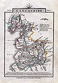 An 1814 map of Lancashire by John Cary which shows many of the turnpike roads.
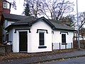 The Grade II listed Kersal Bar Toll House, [10] along the Manchester and Bury New Road turnpike road.
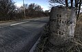 A milestone along the Warrington and Lower Irlam turnpike road, near Rixton. The opposite side gives the distance to Warrington.
 A milestone on Patricroft Bridge, along the Barton and Moses Gate turnpike road, near Eccles. Note the older spelling of 'Altringham' - latterly Altrincham.
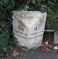 A milestone along the Manchester to Wilmslow turnpike road, in Withington
 This milestone, part of the Smut Inn public house, indicates the distance between Oldham and Manchester Town Hall.