
Turtle Creek is the name of small tributary creek of the Trinity River, with headwaters in northern Dallas, in Dallas County, Texas.
Turtle Creek is the name of small tributary creek of the Trinity River, with headwaters in northern Dallas, in Dallas County, Texas.
Turtle Creek generally runs southwest through North Dallas, passing through Highland Park (an incorporated city and enclave surrounded by Dallas), then back into Dallas through the Oak Lawn community and Turtle Creek neighborhood alongside Turtle Creek Boulevard, through Reverchon Park, and ultimately through the West Dallas Design District where it flows into the Trinity River Meanders culverts.
The Meanders are the original riverbed of the Trinity River through Dallas. For flood control purposes, the Meanders section was rerouted through underground culverts in the early 20th century. The main riverbed was also redirected through a new channel excavated to the west. The channel was engineered with levees and pumps, allowing real estate development of an industrial district in the area. [1]

Dallas is a city in the U.S. state of Texas and the largest city in and seat of Dallas County, with portions extending into Collin, Denton, Kaufman and Rockwall counties. With a 2020 census population of 1,304,379, it is the ninth most-populous city in the U.S. and the third-largest in Texas after Houston and San Antonio. Located in North Texas, the city of Dallas is the main core of the largest metropolitan area in the Southern United States and the largest inland metropolitan area in the U.S. that lacks any navigable link to the sea. It is the most populous city in the Dallas–Fort Worth metroplex, the fourth-largest metropolitan area in the country at 7.5 million people.

Dallas County is the second-most populous county in the U.S. state of Texas. As of the 2020 U.S. census, the population was 2,613,539, making it the ninth-most populous county in the country.

Highland Park is a highly affluent town in central Dallas County, Texas, United States. The population was 8,564 at the 2010 census. It is located between the Dallas North Tollway and U.S. Route 75, 4 miles (6 km) north of downtown Dallas.

Trinidad is a city in Henderson County, Texas, United States, near the Trinity River from which the town's name was derived. The population was 886 at the 2010 census, down from 1,091 at the 2000 census.

Rowlett is a city in Dallas and Rockwall counties in the U.S. state of Texas, and an eastern suburb of Dallas. The total population estimate is 73,270 in 2021. It is a growing, upscale community with nearly $1.5 billion in development in the Dallas–Fort Worth metroplex, located on Lake Ray Hubbard.

The Trinity River is a 710 mile long river in Texas, and is the longest river with a watershed entirely within the U.S. state of Texas. It rises in extreme northern Texas, a few miles south of the Red River. The headwaters are separated by the high bluffs on the southern side of the Red River.
Turtle Creek may refer to:

La Réunion was a utopian socialist community formed in 1855 by French, Belgian, and Swiss colonists on the south bank of the Trinity River in central Dallas County, Texas (US). The colony site is a short distance north of Interstate 30 near downtown Dallas. The founder of the community, Victor Prosper Considerant, was a French democratic socialist who directed an international movement based on Fourierism, a set of economic, political, and social beliefs advocated by French philosopher François Marie Charles Fourier. Fourierism subsequently became known as a form of utopian socialism.

White Rock Creek is a 30-mile (48.3 km) creek occupying a chain of four sub-watersheds [1] within the Trinity River Headwaters watershed. From its source near Frisco, Texas at 33°07'54"N/96°46'50"W, this creek runs south-by-south-east through suburban Dallas for 23.5 miles (37.8 km) where it widens into White Rock Lake, then continues south for another 8 miles (12.9 km) to its mouth at 32°43'25"N/96°44'02"W on the Trinity River, of which it is a major tributary.

Johnson Creek is a creek and tributary of the Trinity River watershed in Dallas County and Tarrant County, North Texas.

Red Oak Creek or Bullock Creek is a 35 miles (56 km) stream and tributary of the Trinity River in North Texas.

Reverchon Park is a public park in the Oak Lawn area of Dallas, Texas. It was named for Julien Reverchon.
Turtle Creek is a creek that rises west of Blessing, Texas (USA) in western Matagorda County. It runs 12.5 miles (20 km) southwest to Turtle Bay, west of Palacios.
Bachman Branch is the name of a medium-sized tributary of the Trinity River with headwaters in northwest Dallas, Texas (USA). The tributary is 10 miles (16 km) in length and rises at Forest Lane, 0.5 miles (0.8 km) west of the Dallas North Tollway. It runs south and then west through Bachman Lake and ultimately into the Elm Fork of the Trinity River. The Branch is dammed with the New Frazier dam to provide water to Fishing Hole Lake. New Frasier Dam is on the Elm Fork Of Trinity River in Dallas County, Texas and is used for flood control purposes. Construction was completed in 1965. It is owned by the Dallas Water Utilities New Frasier Dam is a gravity dam. Its height is 16 feet with a length of 180 feet. Its capacity is 651 acre-feet (803,000 m3). Normal storage is 651 acre-feet (803,000 m3)
Trinity Mills was a small community originally settled in 1853 on land that is today part of the city of Carrollton in northwest Dallas County, Texas (USA).

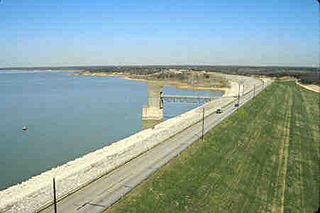
Cedar Creek Reservoir is a reservoir located in Henderson and Kaufman Counties, Texas (USA), 50 miles (80.5 km) southeast of Dallas. It is built on Cedar Creek, which flows into the Trinity River. Floodwaters are discharged through a gated spillway into a discharge channel that connects to the Trinity River.
Grapevine Lake is an American reservoir located in the North Texas region, approximately 20 mi (32 km) northwest of Dallas and northeast of Fort Worth. It was impounded in 1952 by the US Army Corps of Engineers when they dammed Denton Creek, a tributary of Trinity River.

Highland Creek is a river in the Scarborough district of Toronto, Ontario, emptying into Lake Ontario at the eastern end of the Scarborough Bluffs. It is home to several species of fish including trout, carp, bass and salmon. It is a meandering river which, like most rivers in Toronto, travels through a glacial ravine formed after the last Ice Age. The Highland Creek watershed, including tributaries, is almost entirely contained within Scarborough.

The Trinity Strand Trail is a proposed 7.8-mile, hike/bike commuter and recreational trail that will run along the course of the original Trinity River in Dallas, Texas (USA), also known as Old Meanders. This part of the Trinity River flows through the heart of the Dallas Design District. Trinity Strand Trail plays a key part in the vision for the Old Trinity River corridor. It will provide a recreational resource for the area and will also connect to Katy Trail, the Southwestern Medical District, Dallas Market Center and several residential and commercial properties.
Sand Branch is an unincorporated community in Dallas County, Texas, United States. According to the Handbook of Texas, the community had an estimated population of 400 in 2000. The community did not participate in the 2010 Census. More recent (2019) estimates put the population around 100.