
Loch is the Irish, Scottish Gaelic and Scots word for a lake or for a sea inlet. It is cognate with the Manx lough, Cornish logh, and one of the Welsh words for lake, llwch.

Inlet is a town in Hamilton County, New York, United States. The population was 333 at the 2010 census. The name is derived from its location at the east end (inlet) of Fourth Lake, part of the Fulton Chain of Lakes.

Port Alberni is a city located on Vancouver Island in the province of British Columbia, Canada.

The Kenai Peninsula is a large peninsula jutting from the coast of Southcentral Alaska. The name Kenai is derived from the word "Kenaitze" or "Kenaitze Indian Tribe", the name of the Native Athabascan Alaskan tribe, the Kahtnuht’ana Dena’ina, that historically inhabited the area. They called the Kenai Peninsula Yaghanen.

An inlet is an indentation of a shoreline, usually long and narrow, such as a small bay or arm, that often leads to an enclosed body of salt water, such as a sound, bay, lagoon, or marsh.

The Twin Ports of Duluth, Minnesota and Superior, Wisconsin, are located at the western part of Lake Superior and together are considered the largest freshwater port in the world. They are twin cities and seaports, connected to the Atlantic Ocean through the Great Lakes and the Saint Lawrence Seaway.

Lake Clark National Park and Preserve is an American national park in southwest Alaska, about 100 miles (160 km) southwest of Anchorage. The park was first proclaimed a national monument in 1978, then established as a national park and preserve in 1980 by the Alaska National Interest Lands Conservation Act. The park includes many streams and lakes vital to the Bristol Bay salmon fishery, including its namesake Lake Clark. A wide variety of recreational activities may be pursued in the park and preserve year-round. The park protects rainforests along the coastline of Cook Inlet, alpine tundra, glaciers, glacial lakes, major salmon-bearing rivers, and two volcanoes, Mount Redoubt and Mount Iliamna. Mount Redoubt is active, erupting in 1989 and 2009. The wide variety of ecosystems in the park mean that virtually all major Alaskan animals, terrestrial and marine, may be seen in and around the park. Salmon, particularly sockeye salmon, play a major role in the ecosystem and the local economy. The Kvichak River is the world's most productive watershed for sockeye salmon. Large populations of brown bears are attracted to feed on the spawning salmon in the Kijik River and at Silver Salmon Creek. Bear watching is a common activity in the park.

A body of water or waterbody is any significant accumulation of water, generally on a planet's surface. The term most often refers to oceans, seas, and lakes, but it includes smaller pools of water such as ponds, wetlands, or more rarely, puddles. A body of water does not have to be still or contained; rivers, streams, canals, and other geographical features where water moves from one place to another are also considered bodies of water.
Lake Ray Hubbard, formerly Forney Lake, is a fresh water impoundment (reservoir) located in Dallas, Texas in the counties of Dallas, Kaufman, Collin, and Rockwall just north of the City of Forney. It was created by the construction of the Rockwall-Forney Dam which impounded the East Fork Trinity River.
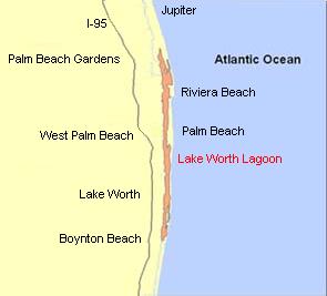
The Lake Worth Lagoon is a lagoon located in Palm Beach County, Florida. It runs parallel to the coast, and is separated from the Atlantic Ocean by barrier beaches, including Palm Beach Island. The lagoon is connected to the Atlantic Ocean by two permanent, man-made inlets.

The Tidal Basin is a partially man-made reservoir between the Potomac River and the Washington Channel in Washington, D.C. It is part of West Potomac Park and is a focal point of the National Cherry Blossom Festival held each spring. The Jefferson Memorial, the Martin Luther King, Jr. National Memorial, the Franklin Delano Roosevelt Memorial, and the George Mason Memorial are situated adjacent to the Tidal Basin. The basin covers an area of about 107 acres (43 ha) and is 10 feet (3.0 m) deep.

Luktvatnet is a lake that lies in the northern part of the municipality of Vefsn in Nordland county, Norway. The 3.76-square-kilometre (1.45 sq mi) lake lies between the mountains Korgfjellet and Lukttinden, about 5 kilometres (3.1 mi) south of the village of Elsfjord. The European route E06 highway passes along the northern shore of the lake.
Goksjø is a lake in the municipalities of Sandefjord, Larvik and Andebu in Vestfold county, Norway. Goksjø is 5 km from north to south, and has a circumference of 20 km. At its deepest, Goksjø is no deeper than 26 meters. Goksjø has an elevation of 28 meters above sea level. It is the largest lake in Sandefjord, and the third-largest in Vestfold County. It is surrounded by rural agricultural lands, and flooding occurs on a regular basis.

Indian Arm is a steep-sided glacial fjord adjacent to the city of Vancouver in southwestern British Columbia. Formed during the last Ice Age, it extends due north from Burrard Inlet, between the communities of Belcarra and the District of North Vancouver, then on into mountainous wilderness. Burrard Inlet and the opening of Indian Arm was mapped by Captain George Vancouver and fully explored days later by Dionisio Alcalá Galiano in June 1792.

Chesterfield Inlet is an inlet in Kivalliq Region, Nunavut, Canada. It is an arm of northwestern Hudson Bay, and the end point of the Thelon River after its passage through Baker Lake. Cross Bay, a large widening of the inlet, occurs 30 km (19 mi) east of Baker Lake. There are several islands located within the inlet.
Chantrey Inlet (Tariunnuaq) is a bay on the Arctic coast of Canada. It marks the southeast "corner" where the generally east–west coast turns sharply north. To the west is the Adelaide Peninsula and to the east is mainland. King William Island shelters it to the northwest. If King William Island were not an island then Chantry Inlet, Rae Strait, Wellington Strait and James Ross Strait would be a single large bay. To the west the Simpson Strait separates King William Island from the Adelaide Peninsula. Its mouth is marked by Point Ogle on the west and Cape Britannia on the east. West of Point Ogle is Barrow Bay, Starvation Cove and Point Richardson. The Back River enters from the south. Near its mouth is a weather station on the Hayes River. Montreal Island is contained within the Inlet. It is 100 mi (160 km) long and 50 mi (80 km) wide at its mouth.

The Pemadumcook Chain of Lakes are a set of large lakes in north-central Maine in the United States.

Taku Inlet is an inlet located in the U.S. state of Alaska. It extends 18 miles (29 km) in a northeast direction from Stephens Passage in the Alexander Archipelago, about 12 kilometres (7.5 mi) southeast of Juneau, widening to a basin where discharge from the Taku River and Taku Glacier emerges.
