Gmina Dębno is a rural gmina in Brzesko County, Lesser Poland Voivodeship, in southern Poland. Its seat is the village of Dębno, which lies approximately 8 kilometres (5 mi) east of Brzesko and 57 km (35 mi) east of the regional capital Kraków.
Gmina Gnojnik is a rural gmina in Brzesko County, Lesser Poland Voivodeship, in southern Poland. Its seat is the village of Gnojnik, which lies approximately 10 kilometres (6 mi) south of Brzesko and 52 km (32 mi) south-east of the regional capital Kraków.
Gmina Iwkowa is a rural gmina in Brzesko County, Lesser Poland Voivodeship, in southern Poland. Its seat is the village of Iwkowa, which lies approximately 18 kilometres (11 mi) south of Brzesko and 53 km (33 mi) south-east of the regional capital Kraków.

Sterkowiec is a village in the administrative district of Gmina Brzesko, within Brzesko County, Lesser Poland Voivodeship, in southern Poland. It lies approximately 5 kilometres (3 mi) north-east of Brzesko and 53 km (33 mi) east of the regional capital Kraków.
Łęki is a village in the administrative district of Gmina Borzęcin, within Brzesko County, Lesser Poland Voivodeship, in southern Poland. It lies approximately 8 kilometres (5 mi) south-west of Borzęcin, 7 km (4 mi) north-east of Brzesko, and 53 km (33 mi) east of the regional capital Kraków.
Będzieszyna is a village in the administrative district of Gmina Czchów, within Brzesko County, Lesser Poland Voivodeship, in southern Poland. It lies approximately 5 kilometres (3 mi) south-west of Czchów, 17 km (11 mi) south of Brzesko, and 58 km (36 mi) south-east of the regional capital Kraków.
Biskupice Melsztyńskie is a village in the administrative district of Gmina Czchów, within Brzesko County, Lesser Poland Voivodeship, in southern Poland. It lies approximately 4 kilometres (2 mi) north-east of Czchów, 14 km (9 mi) south-east of Brzesko, and 60 km (37 mi) east of the regional capital Kraków.
Domosławice is a village in the administrative district of Gmina Czchów, within Brzesko County, Lesser Poland Voivodeship, in southern Poland. It lies approximately 4 kilometres (2 mi) north-east of Czchów, 14 km (9 mi) south-east of Brzesko, and 61 km (38 mi) east of the regional capital Kraków.
Jurków is a village in the administrative district of Gmina Czchów, within Brzesko County, Lesser Poland Voivodeship, in southern Poland. It lies approximately 1 kilometre (1 mi) south-west of Czchów, 14 km (9 mi) south of Brzesko, and 59 km (37 mi) south-east of the regional capital Kraków.
Piaski-Drużków is a village in the administrative district of Gmina Czchów, within Brzesko County, Lesser Poland Voivodeship, in southern Poland. It lies approximately 4 kilometres (2 mi) south of Czchów, 18 km (11 mi) south of Brzesko, and 60 km (37 mi) south-east of the regional capital Kraków.
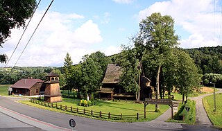
Tymowa is a village in the administrative district of Gmina Czchów, within Brzesko County, Lesser Poland Voivodeship, in southern Poland. It lies approximately 4 kilometres (2 mi) west of Czchów, 13 km (8 mi) south of Brzesko, and 56 km (35 mi) south-east of the regional capital Kraków.
Wytrzyszczka is a village in the administrative district of Gmina Czchów, within Brzesko County, Lesser Poland Voivodeship, in southern Poland. It lies approximately 6 kilometres (4 mi) south-west of Czchów, 17 km (11 mi) south of Brzesko, and 57 km (35 mi) south-east of the regional capital Kraków.
Złota is a village in the administrative district of Gmina Czchów, within Brzesko County, Lesser Poland Voivodeship, in southern Poland. It lies approximately 4 kilometres (2 mi) north of Czchów, 12 km (7 mi) south-east of Brzesko, and 59 km (37 mi) east of the regional capital Kraków.
Jastew is a village in the administrative district of Gmina Dębno, within Brzesko County, Lesser Poland Voivodeship, in southern Poland. It lies approximately 4 kilometres (2 mi) north-west of Dębno, 4 km (2 mi) east of Brzesko, and 54 km (34 mi) east of the regional capital Kraków.
Łysa Góra is a village in the administrative district of Gmina Dębno, within Brzesko County, Lesser Poland Voivodeship, in southern Poland. It lies approximately 5 kilometres (3 mi) south of Dębno, 11 km (7 mi) south-east of Brzesko, and 60 km (37 mi) east of the regional capital Kraków.
Sufczyn is a village in the administrative district of Gmina Dębno, within Brzesko County, Lesser Poland Voivodeship, in southern Poland. It lies approximately 4 kilometres (2 mi) south-east of Dębno, 11 km (7 mi) east of Brzesko, and 60 km (37 mi) east of the regional capital Kraków.
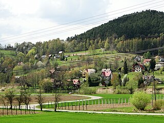
Gosprzydowa is a village in the administrative district of Gmina Gnojnik, within Brzesko County, Lesser Poland Voivodeship, in southern Poland. It lies approximately 3 kilometres (2 mi) south-west of Gnojnik, 12 km (7 mi) south of Brzesko, and 51 km (32 mi) south-east of the regional capital Kraków.
Żerków is a village in the administrative district of Gmina Gnojnik, within Brzesko County, Lesser Poland Voivodeship, in southern Poland. It lies approximately 5 kilometres (3 mi) east of Gnojnik, 10 km (6 mi) south of Brzesko, and 56 km (35 mi) east of the regional capital Kraków.
Rylowa is a village in the administrative district of Gmina Szczurowa, within Brzesko County, Lesser Poland Voivodeship, in southern Poland. It lies approximately 3 kilometres (2 mi) south-east of Szczurowa, 16 km (10 mi) north of Brzesko, and 53 km (33 mi) east of the regional capital Kraków.


