
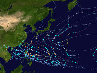
The 2003 Pacific typhoon season was a slightly below average yearlong period of tropical cyclogenesis exhibiting the development of 45 tropical depressions, of which 21 became named storms; of those, 14 became typhoons. Though every month with the exception of February and March featured tropical activity, most storms developed from May through October. During the season, tropical cyclones affected the Philippines, Japan, China, the Korean Peninsula, Indochina, and various islands in the western Pacific.

The 2002 Pacific typhoon season was a slightly above average Pacific typhoon season, producing twenty-six named storms, fifteen becoming typhoons, and eight super typhoons. It had an ACE over 400 units, making it one of the most active seasons worldwide. It was an event in the annual cycle of tropical cyclone formation, in which tropical cyclones form in the western Pacific Ocean. The season ran throughout 2002, though most tropical cyclones typically develop between May and October. The season's first named storm, Tapah, developed on January 11, while the season's last named storm, Pongsona, dissipated on December 11. The season's first typhoon, Mitag, reached typhoon status on March 1, and became the first super typhoon of the year four days later.

The 2001 Pacific typhoon season was an average season with twenty-six named storms, sixteen typhoons and three super typhoons, with a near normal Accumulated Cyclone Energy (ACE) of 307.3 units. It ran year-round in 2001, with most tropical cyclones in the northwestern Pacific Ocean tending between May and November.

The 1992 Pacific typhoon season was the fourth consecutive above-average season, producing 31 tropical storms, 16 typhoons and five super typhoons. It had no official bounds; it ran year-round in 1992. Despite this, most tropical cyclones tend to form in the northwestern Pacific Ocean between May and November. These dates conventionally delimit the period of each year when most tropical cyclones form in the northwestern Pacific Ocean.

The 1988 Pacific typhoon season was a very active season in terms of named storms, though it only featured 11 typhoons and 1 super typhoon. It had no official bounds; it ran year-round in 1988, but most tropical cyclones formed between May and November. Tropical storms that formed in the entire west Pacific basin were assigned a name by the Joint Typhoon Warning Center. Tropical depressions that enter or form in the Philippine area of responsibility are assigned a name by the Philippine Atmospheric, Geophysical and Astronomical Services Administration or PAGASA. This can often result in the same storm having two names.
The 1980 Pacific typhoon season was a slightly-below average season when compared to the long-term average, though it featured several intense storms. It ran year-round in 1980, but most tropical cyclones formed between June and December. These dates conventionally delimit the period of each year when most tropical cyclones form in the northwestern Pacific Ocean. A total of 28 tropical depressions formed this year in the Western Pacific, of which 24 became tropical storms and were assigned a name by the Joint Typhoon Warning Center. Beginning in March, tropical cyclones formed in each subsequent month through December. Of the 24 named storms, 15 storms reached typhoon intensity, of which 2 reached super typhoon strength.

The 1959 Pacific typhoon season was regarded as one of the most devastating years for Pacific typhoons on record, with China, Japan and South Korea sustaining catastrophic losses. It was an event in the annual cycle of tropical cyclone formation. The season had no official bounds, but tropical cyclones in the Western Pacific Ocean normally develop between May and October.

The 1971 Pacific typhoon season was an extremely active season that featured the second highest typhoon count on record. It has no official bounds; it ran year-round in 1971, but most tropical cyclones tend to form in the northwestern Pacific Ocean between June and December. These dates conventionally delimit the period of each year when most tropical cyclones form in the northwestern Pacific Ocean.

The 1962 Pacific typhoon season had no official bounds; there was activity in every month but January, March, and June, but most tropical cyclones form in the northwestern Pacific Ocean between May and November and this conventionally delimits the season.

Typhoon Rose, known in the Philippines as Typhoon Uring, was the most violent and intense tropical cyclone to strike Hong Kong since Typhoon Wanda in 1962. The 21st named storm of the 1971 Pacific typhoon season, Rose developed from an area of disturbed weather while west of Guam on August 9. Moving west-northwestward, the storm briefly became a typhoon on the following day. After weakening to a tropical storm on August 11, Rose re-intensified into a typhoon several hours later. The system then curved westward and reached a primary peak intensity with winds of 205 km/h (127 mph) on August 13. Later that day, the typhoon made landfall near Palanan, Isabela in the Philippines. Rose weakened significantly while crossing the island of Luzon and was a minimal typhoon upon reaching the South China Sea on August 14.

The 2019 Pacific typhoon season was a devastating season that became the costliest on record, just ahead of the previous year and 2023, mainly due to the catastrophic damage wrought by typhoons Lekima, Faxai, and Hagibis. The season was the fifth and final consecutive to have above average tropical cyclone activity that produced a total of 29 named storms, 17 typhoons, and 5 super typhoons. The season's first named storm, Pabuk, reached tropical storm status on January 1, becoming the earliest-forming tropical storm of the western Pacific Ocean on record, breaking the previous record that was held by Typhoon Alice in 1979. The season's first typhoon, Wutip, reached typhoon status on February 20. Wutip further intensified into a super typhoon on February 23, becoming the strongest February typhoon on record, and the strongest tropical cyclone recorded in February in the Northern Hemisphere. The season's last named storm, Phanfone, dissipated on December 29 after it made landfall in the Philippines.

Typhoon Sally, known in the Philippines as Typhoon Maring, was an intense tropical cyclone that caused widespread damage across southeastern Asia, particularly in China, in September 1996. Forming well east of the Philippines on 5 September, Sally quickly intensified as it tracked westward within favorable conditions. The system reached tropical storm intensity several hours after tropical cyclogenesis was completed, and strengthened further into typhoon intensity the following day. On 7 September, Sally reached super typhoon status shortly before attaining its peak intensity with maximum sustained winds of 260 km/h (160 mph) and a barometric pressure of 940 mbar. Quickly moving across the South China Sea, Sally substantially weakened but remained a strong typhoon before making its first landfall on the Leizhou Peninsula on 9 September. The tropical cyclone's trek brought it briefly over the Gulf of Tonkin before making a final landfall near the border of China and Vietnam. The typhoon rapidly deteriorated inland and dissipated later that day.

Most of the tropical cyclones of the 2013 Pacific typhoon season formed between May and November of that year. The scope of this article is the Pacific Ocean north of the equator, between 100°E and the International Date Line. Tropical storms which form in the Western Pacific basin are assigned a name by the Japan Meteorological Agency (JMA). Tropical depressions forming in this basin are given a number with a "W" suffix by the United States' Joint Typhoon Warning Center (JTWC). The Philippine Atmospheric, Geophysical and Astronomical Services Administration (PAGASA) assigns names to tropical cyclones that enter or form in the Philippine area of responsibility, but these names are not in common use outside the Philippines.

This timeline documents all of the events of the 2014 Pacific typhoon season. Most of the tropical cyclones forming between May and November. The scope of this article is limited to the Pacific Ocean, north of the equator between 100°E and the International Date Line. Tropical storms that form in the entire Western Pacific basin are assigned a name by the Japan Meteorological Agency. Tropical depressions that form in this basin are given a number with a "W" suffix by the United States' Joint Typhoon Warning Center. In addition, the Philippine Atmospheric, Geophysical and Astronomical Services Administration (PAGASA) assigns names to tropical cyclones that enter or form in the Philippine area of responsibility. These names, however, are not in common use outside of the Philippines.
The effects of Typhoon Bopha in the Caroline Islands were significant, though limited in extent in comparison to the cyclone's intensity. Typhoon Bopha originated from a tropical depression south of Pohnpei on November 25, 2012, and tracked generally westward for more than a week. During this time, it threatened several islands across Micronesia, prompting the issuance of typhoon watches and warnings. The system skirted the Nomoi Islands on November 28 where it caused limited damage. Thereafter, it became a threat to Palau as an intense typhoon. Residents there boarded up their homes and some evacuated to public shelters while officials enacted a strict curfew during the typhoon's passage. Bopha passed 55 km (34 mi) south of Angaur island, or 100 km (62 mi) south of Babeldaob, on December 2 with winds of 185 km/h (115 mph).

Typhoon Lingling, known in the Philippines as Typhoon Nanang, was a deadly typhoon that struck the Philippines and Vietnam in 2001 and caused 379 deaths. The name "Lingling" was given by Hong Kong. The 39th tropical depression, 22nd named storm, and 13th typhoon of the 2001 Pacific typhoon season, Lingling developed into a tropical depression on November 6 and given the local name Nanang by the PAGASA. The next day, it was upgraded into a tropical storm and given the name Lingling by the Japan Meteorological Agency (JMA). Lingling's intensity briefly stagnated as it moved over Visayas before resuming intensification and intensifying into a severe tropical storm on November 8. One day later, both the JMA and the Joint Typhoon Warning Center (JTWC) upgraded Lingling to a typhoon as it exited the Philippine archipelago and moved into the South China Sea. After intensifying into a typhoon, Lingling began to quickly intensify, peaking with 10-min sustained winds of 155 km/h (96 mph) and 1-min sustained winds of 215 km/h (134 mph), with a minimum central pressure of 940 mbar (28 inHg). Lingling began to weaken as it approached the Vietnamese coast, before making landfall on November 11 at 18:00 UTC. Lingling rapidly weakened afterward, dissipating on November 12.
Typhoon Faith, known in the Philippines as Typhoon Norming, struck both the Philippines and Vietnam during December 1998. A tropical disturbance developed within the vicinity of the western Caroline Islands during early December. At midday on December 8, the system developed into a tropical depression. Tracking northwest at a brisk pace, the depression gradually intensified, and was upgraded into a tropical storm at noon on December 9. Quickly intensifying, Faith turned to the west-northwest, and after tracking near Samar Island on the evening of December 10, Faith attained typhoon intensity. After clipping the northern tip of Palawan Island, the typhoon entered the South China Sea at peak intensity. Across the Philippines, 33 people were killed, with 30 others wounded and 36 others listed missing. A total of 6,423 homes were damaged and 3,234 houses were destroyed, leaving more than 20,000 homeless. Damage was estimated at $25.9 million, with $6.82 million from crops, $15.9 million from public infrastructure, and $3.37 million from private infrastructure.

Typhoon Percy, known in the Philippines as Typhoon Klaring, was the third tropical cyclone to affect the country in 1990. The fourth and the last tropical cyclone to be formed in June of the 1990 Pacific typhoon season, Typhoon Percy originated from an area of disturbed weather spawned by the Western Pacific monsoon trough on June 20. That same day, the disturbance was classified as a tropical depression as it slowly organized and on June 21, the depression obtained tropical storm intensity. After initially tracking westward, Percy turned towards the southwest while slowly deepening. During this time, Percy affected several of the Carolina Islands. Thirty homes were damaged and airline services were halted in and out of Yap. Farther south-southwest, seven homes were destroyed on the Ngulu Atoll. Furthermore, one boy was killed on Koror, where numerous homes lost their roofs and communication lines were downed. Percy then turned back to the west-northwest and became a typhoon on June 23. It then began to deepen at a faster rate, with Percy attaining its maximum intensity of 145 km/h (90 mph) on June 25. Two days later, on June 27, increased wind shear began to induce a weakening trend and the typhoon brushed Luzon, where eight people were killed and over 30,000 lost their homes. Despite that however, damages in the country was minor.

Typhoon Lola, known in the Philippines as Typhoon Monang, was a deadly typhoon that impacted the Philippines and Indochina. The 47th tropical depression, 26th named storm, and 14th typhoon of the 1993 Pacific typhoon season, the origins of Lola can be traced back to an active near-equatorial trough. The JTWC began monitoring an area of convection on November 27, and on December 1, it developed into a tropical depression. The JMA upgraded the depression to a tropical storm the next day, with the JTWC giving it the name Lola on December 3. 12 hours later, the JMA upgraded Lola to a severe tropical storm. On December 4 at 6:00 UTC, the JTWC upgraded Lola to a typhoon. Shortly after, Lola reached its initial peak intensity, with the JMA assessing that it had peaked with a minimum central pressure of 955 hPa; Lola made landfall near the municipality of Vinzons on December 5 at 12:00 UTC. After making landfall, Lola weakened to a tropical storm as it emerged over the South China Sea on December 6, before re-strengthening into a typhoon. After strengthening into a typhoon, Lola began to quickly intensify, reaching its peak intensity with 1-min winds of 195 km/h (120 mph) on December 8 at 12:00 UTC. Lola weakened slightly before making its final landfall near the city of Camh Ranh as a Category 2-equivalent storm. Lola quickly weakened over land, dissipating on December 9.
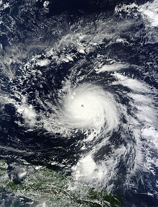
Typhoon Surigae, known in the Philippines as Super Typhoon Bising, was the strongest tropical cyclone worldwide in 2021 and the most powerful to form before the month of May in the Northern Hemisphere in any calendar year. The second named storm, first typhoon and first super typhoon of the 2021 Pacific typhoon season, Surigae originated from a low-pressure area south of the Micronesian island of Woleai. The low organized into a tropical depression on April 12. At 18:00 UTC that day, it strengthened into a tropical storm and was named Surigae by the Japan Meteorological Agency (JMA). Very favorable environmental conditions then allowed Surigae to begin a bout of rapid intensification after becoming a typhoon on April 15; by April 17, the storm reached its peak intensity with 10-minute sustained winds of 220 km/h (140 mph), 1-minute sustained winds of 315 km/h (195 mph), and a minimum pressure of 895 hPa (26.4 inHg). Afterward, weakening outflow and an eyewall replacement cycle caused Surigae to gradually weaken as its track shifted north-northwestward in the Philippine Sea. Following the eyewall replacement cycle, Surigae became an annular tropical cyclone on April 19, and restrengthened slightly. On April 22, the storm began to rapidly weaken as it accelerated northwestward into unfavorable environmental conditions, transitioning into a subtropical storm the next day. The subtropical system subsequently underwent extratropical transition, which it completed by April 24. Three days later, Surigae's remnant explosively intensified into a bomb cyclone near the Aleutian Islands, attaining hurricane-force winds. Afterward, the system gradually weakened as it turned eastward, crossing the International Date Line on April 30 and fully dissipating that same day.

