
Snowdonia, or Eryri, is a mountainous region and national park in North Wales. It contains all 15 mountains in Wales over 3000 feet high, including the country's highest, Snowdon, which is 1,085 metres (3,560 ft) tall. These peaks are all part of the Snowdon, Glyderau, and Carneddau ranges in the north of the region. The shorter Moelwynion and Moel Hebog ranges lie immediately to the south.

The Berwyn range is an isolated and sparsely populated area of moorland in the northeast of Wales, roughly bounded by Llangollen in the northeast, Corwen in the northwest, Bala in the southwest, and Oswestry in the southeast.

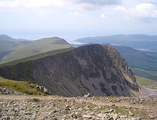
Aran Fawddwy is a mountain in southern Snowdonia, Wales, United Kingdom. It is the highest point of the historic county of Merionethshire. It is the highest peak in the Aran mountain range, the only peak in Wales outside North Snowdonia above 900m, and higher than anywhere in the United Kingdom outside Northern Snowdonia, the Scottish Highlands and the Lake District. The nearest small settlements to the mountain are Dinas Mawddwy to the south, Llanymawddwy to the southeast, Llanuwchllyn on the shores of Bala Lake to the north, and Rhydymain to the west. The nearest settlements with around 2,000 people are Bala and Dolgellau. On the eastern slopes of Aran Fawddwy is the small lake named Creiglyn Dyfi, the source of the River Dyfi. Its sister peak is Aran Benllyn at 885 metres (2,904 ft). There is also a middle peak: Erw y Ddafad-ddu.

Cadair Idris or Cader Idris is a mountain in the Meirionnydd area of Gwynedd, Wales. It lies at the southern end of the Snowdonia National Park near the town of Dolgellau. The peak, which is one of the most popular in Wales for walkers and hikers, is composed largely of Ordovician igneous rocks, with classic glacial erosion features such as cwms, moraines, striated rocks, and roches moutonnées.
Cadair Berwyn, Cader Berwyn or Craig Uchaf is a mountain summit in north-east Wales with a height of 832 metres (2,730 ft) above sea level. It is the highest point in the Berwyn range, the highest in North East Wales and the highest significant summit in Wales outside the National Parks. Cadair Berwyn and Foel Cedig to the west are the two Marilyns that form the Berwyn range. The undulating plateau of the range also includes a large number of other summits above 2,000 feet (610 m), including satellite summits of Cadair Berwyn and many which are classed as Nuttalls.

Arenig Fawr is a mountain in Snowdonia, North Wales, close to Llyn Celyn reservoir, alongside the A4212 between Trawsfynydd and Bala.

Rhinog Fawr is a mountain in Snowdonia, North Wales and forms part of the Rhinogydd range. It is the third highest summit of the Rhinogydd, losing out to Y Llethr and Diffwys respectively. Its smaller cousin Rhinog Fach lies to the south, separated by the pass of Bwlch Drws Ardudwy, while its other neighbour, Moel Ysgyfarnogod lies to the north.

The Llanberis Pass in Snowdonia carries the main road (A4086) from the south-east to Llanberis, over Pen-y-Pass, between the mountain ranges of the Glyderau and the Snowdon massif. At the bottom of the pass is the small village of Nant Peris.

Tal-y-llyn Lake,, also known as Talyllyn Lake and Llyn Myngul, is a large glacial ribbon lake in Gwynedd, North Wales. It is formed by a post-glacial massive landslip damming up the lake within the glaciated valley. The hamlet of Talyllyn lies at the west end of the lake.

Aran Benllyn is a subsidiary summit of Aran Fawddwy in southern Snowdonia, North Wales, Wales, United Kingdom. It is the second highest peak in the Aran mountain range.

Mynydd Moel is the second highest summit of Cadair Idris in the Snowdonia National Park, in Gwynedd, northwest Wales.

Gau Graig is a subsidiary summit of Cadair Idris in the Snowdonia National Park, in Gwynedd, northwest Wales. It lies to the east of Mynydd Moel on a broad grassy plateau. It marks the eastern end of the Cadair Idris ridge.
Cyfrwy is a subsidiary summit of Cadair Idris in the Snowdonia National Park, in Gwynedd, northwest Wales. It lies to the west of Cadair Idris and is often climbed with Cadair Idris by taking the Pony Path.

The River Dysynni is a river in mid Wales. Its source is the Tal-y-llyn Lake just south of the Cadair Idris massif and its mouth is in the Cardigan Bay area of the Irish Sea to the north of Tywyn. It measures about 16 mi (26 km) in length.

Glasgwm is a mountain in Gwynedd, Wales forming part of the Aran range in southern Snowdonia. It is one of the three Marilyns that make up the range, the others being Aran Fawddwy and Esgeiriau Gwynion. To the west is Maesglase and the Dyfi hills, while to the south-west lies Cadair Idris. To the south lies the Plynlimon range. It is 779 metres (2,556 ft) high.

Tarren y Gesail is a mountain in Snowdonia, north Wales. It is one of the Marilyns of the Cadair Idris group.

Tarrenhendre is a mountain in Snowdonia, North Wales. It is one of the Marilyns in the Cadair Idris group.

Craig-y-llyn is a subsidiary summit of Cadair Idris in the Snowdonia National Park, in Gwynedd, northwest Wales. It lies at the western end of the long Cadair Idris ridge. Its north-facing cwm houses the small glacial lake, Llyn Cyri. The southern flanks have gentle slopes, while the northern are very steep and contain broken crags.

Moel Emoel is a hill within the Snowdonia National Park in Gwynedd, North Wales.
Barmouth Bay is a bay in Gwynedd on the west coast of Wales, forming a part of the much larger Cardigan Bay. The coast fronting onto the bay is within the Snowdonia National Park at its northern and southern extremities but the coastal town of Barmouth and village of Fairbourne at the back of the bay are excluded from the designated area. Inland of the bay is the sandy Mawddach estuary, through which the tidal channel of the river winds before emptying into the bay beyond Fairbourne Spit, a shingle promontory stretching north from Fairbourne. A sandbank known as 'The Bar' guards the entrance to this channel from Cardigan Bay. The Cambrian Coast Line runs along the narrow coastal strip at the back of the bay, crossing the Mawddach via Barmouth Bridge which also carries the Wales Coast Path.
