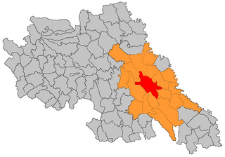
Târgu Mureș metropolitan area

Last updated
Târgu Mureș metropolitan area
Metropolitan area
Coordinates: 46°32′N24°33′E / 46.533°N 24.550°E / 46.533; 24.550 Coordinates: 46°32′N24°33′E / 46.533°N 24.550°E / 46.533; 24.550
Country Flag of Romania.svg  Romania
County Actual Mures county CoA.png Mureș
Central Municipality Târgu Mureș
Functional 2005
Area
  Total 656.29 km2 (253.39 sq mi)
Population (2011 census)
  Total 209,532
  Density 314.6/km2 (815/sq mi)
Time zone EET (UTC+2)
  Summer (DST) EEST (UTC+3)
Postal Code 540xyz1
Area code(s) +40 x652
Website http://www.tgmures-metropolitan.ro/home

The Târgu Mureș metropolitan area is a metropolitan area in Târgu Mureș, Romania. It was founded in 2005. It has a population of 209,532 as of the 2011 census. It is Romania's only metropolitan area where Hungarians form the largest ethnic group, with 98,593 people. The Romanian population is 95,867. Other ethnicities include Romani, Germans, Italians, and Jews.

Metropolitan area region consisting of a densely populated urban core and its less-populated but economically-linked surroundings

A metropolitan area, sometimes referred to as a metro area or commuter belt, is a region consisting of a densely populated urban core and its less-populated surrounding territories, sharing industry, infrastructure, and housing. A metro area usually comprises multiple jurisdictions and municipalities: neighborhoods, townships, boroughs, cities, towns, exurbs, suburbs, counties, districts, states, and even nations like the eurodistricts. As social, economic and political institutions have changed, metropolitan areas have become key economic and political regions. Metropolitan areas include one or more urban areas, as well as satellite cities, towns and intervening rural areas that are socioeconomically tied to the urban core, typically measured by commuting patterns. In the United States, the concept of the metropolitan statistical area has gained prominence.

Târgu Mureș City in Mureș, Romania

Târgu Mureș is the seat of Mureș County in the north-central part of Romania. It is the 16th largest Romanian city, with 134,290 inhabitants as of the 2011 census. It lies on the Mureș river, the second longest river in Romania.

Romania Sovereign state in Europe

Romania is a country located at the crossroads of Central, Eastern, and Southeastern Europe. It borders the Black Sea to the southeast, Bulgaria to the south, Ukraine to the north, Hungary to the west, Serbia to the southwest, and Moldova to the east. It has a predominantly temperate-continental climate. With a total area of 238,397 square kilometres (92,046 sq mi), Romania is the 12th largest country and also the 7th most populous member state of the European Union, having almost 20 million inhabitants. Its capital and largest city is Bucharest, and other major urban areas include Cluj-Napoca, Timișoara, Iași, Constanța, Craiova, and Brașov.

Contents

As defined by Eurostat, the Târgu Mureș functional urban area has a population of 180,922 residents (as of 2015). [1]

Eurostat statistics agency of the European Union

Eurostat is a Directorate-General of the European Commission located in Luxembourg. Its main responsibilities are to provide statistical information to the institutions of the European Union (EU) and to promote the harmonisation of statistical methods across its member states and candidates for accession as well as EFTA countries. The organisations in the different countries that cooperate with Eurostat are summarised under the concept of the European Statistical System.
Composition

Tărgu Mureș metropolitan area (2011) [2]
Cities/CommunesPopulation Romanians Hungarians Other
Târgu Mureș 134,290 69,702 60,669 3,919
Sângeorgiu de Mureș 9,304 3,435 4,681 1,188
Sâncraiu de Mureș 7,489 4,671 2,254 564
Ungheni 6,945 5,039 580 977
Pănet 6,033 739 4,707 587
Ceuașu de Câmpie 5,964 2,547 2,624 793
Ernei 5,835 452 4,284 1,099
Cristești 5,824 2,465 2,512 847
Sântana de Mureș 5,723 2,868 2,309 546
Acățari 4,738 91 4,067 580
Crăciunești 4,470 110 2,827 1,533
Sânpaul 4,233 1,309 1,466 1,458
Livezeni 3,266 1,008 1,640 618
Gheorghe Doja 2,982 617 2,169 196
Corunca 2,785 814 1,804 167
Total209,53295,86798,59315,072
Percentage 100% 45.8% 47.1% 7.1%

Related Research Articles

Transylvania Historical region of Romania

Transylvania is a historical region which is located in central Romania. Bound on the east and south by its natural borders, the Carpathian mountain range, historical Transylvania extended westward to the Apuseni Mountains. The term sometimes encompasses not only Transylvania proper, but also parts of the historical regions of Crișana and Maramureș, and occasionally the Romanian part of Banat.

Iași County County in Nord-Est, Romania

Iași County is a county (județ) of Romania, in Moldavia, with the administrative seat at Iași. It is the most populous county in Romania, after the Municipality of Bucharest.

Mureș County County in Centru, Romania

Mureș County is a county (județ) of Romania, in the historical region of Transylvania, with the administrative centre in Târgu Mureș. The county was established in 1968, after the administrative reorganization that re-introduced the historical judeţ (county) system, still used today. This reform eliminated the previous Mureș-Magyar Autonomous Region, which had been created in 1952 within the People's Republic of Romania. Mureș county has a vibrant multicultural fabric that includes Hungarian-speaking Székelys and Transylvanian Saxons, with a rich heritage of fortified churches and towns.

Székelys ethnic group

The Székelys, sometimes also referred to as Szeklers, are a subgroup of the Hungarian people living mostly in the Székely Land in Romania. A significant population descending from the Székelys of Bukovina lives in Tolna and Baranya counties in Hungary and in certain districts of Vojvodina, Serbia.

Luduș Town in Mureș County, Romania

Luduș is a town in central Romania in Mureș County, 44 km south-west from the county's capital Târgu Mureș.

Székely Land geographical object

The Székely Land or Szeklerland is a historic and ethnographic area in Romania, inhabited mainly by Hungarians. Its cultural centre is the city of Târgu Mureș (Marosvásárhely), the largest settlement in the region.

The larger urban zone (LUZ), or Functional Urban Area (FUA), is a measure of the population and expanse of metropolitan areas in Europe. It consists of a city and its commuting zone.

Iași metropolitan area Metropolitan area in Iași, Romania

The Iași Metropolitan Area is a metropolitan association in Iași County, Romania, that includes the municipality of Iași and 13 nearby communes.

Bucharest metropolitan area Metropolitan area in Romania

The Bucharest Metropolitan Area is a proposed metropolitan area project that includes Bucharest, the capital city of Romania, and surrounding communes. If completed, it would have a population of about 2.3 million, only slightly larger than that of the city proper. It would also be a member of the METREX network.

Metropolitan areas in Romania

There are 10 metropolitan areas in Romania that have been constituted as of 2013.

Cluj-Napoca metropolitan area Metropolitan area in Cluj County, Romania

The Cluj-Napoca metropolitan area is a metropolitan area founded in December 2008. It has a population of 411,379 of which 324,576 are living in Cluj-Napoca and 86,803 in 17 communes: Aiton, Apahida, Baciu, Bonţida, Borşa, Căianu, Chinteni, Ciurila, Cojocna, Feleacu, Floreşti, Gârbău, Gilău, Jucu, Petreștii de Jos, Tureni, Vultureni.

Oradea metropolitan area Metropolitan area in Bihor, Romania

Oradea metropolitan area is a metropolitan area located in Western Romania, in the County of Bihor, Crişana, Transylvania, Romania and was founded on 9 May 2005.

Lower Danube metropolitan area Metropolitan area in Romania

The Danube metropolitan area or Galați-Brăila metropolitan area is a proposed metropolitan area project in Romania. It would be formed from the cities of Galaţi and Brăila. Together they have a population of about 430,000 people.

Bacău metropolitan area Metropolitan area in Bacău, Romania

The Bacău metropolitan area is a proposed metropolitan area project that includes the urban area of Bacău and it would extend to Buhuși. It includes the communes of Letea Veche, Buhoci, Luizi-Călugăra, Săucești, Hemeiuș, Gârleni, Racova, Mărgineni, Măgura and others. If completed, the metropolitan would have an estimated population of 188,709.

Craiova metropolitan area Metropolitan area in Dolj, Romania

Craiova metropolitan area is a metropolitan area, founded on 11 February 2009, and formed by Craiova and other 23 other nearby communities. The population of this area is 356,544.

Ploiești metropolitan area Metropolitan area in Prahova, Romania

Ploieşti metropolitan area is a proposed metropolitan area project, launched in 2003.

Satu Mare metropolitan area Metropolitan Area in Satu Mare, Romania

The Satu Mare Metropolitan Area is a metropolitan area of Romania founded on April 26, 2013 around the capital of Satu Mare county: Satu Mare. It has a population of 233,306 and, besides Satu Mare, it includes four cities and towns and 26 villages.

Western Moldavia Historical region of Romania

Western Moldavia, also called Moldavia or Romanian Moldavia, is the historic and geographical part of the former Principality of Moldavia situated in eastern and north-eastern Romania. Until its union with Wallachia in 1859, the Principality of Moldavia also included, at various times in its history, the regions of Bessarabia, all of Bukovina, and Hertza; the larger part of the former is nowadays the independent state of Moldova, while the rest of it, the northern part of Bukovina, and Hertza form territories of Ukraine.

References