Gjerstad is a municipality in Aust-Agder county, Norway. It is located in the traditional region of Sørlandet, in the southeastern part of the county, along the border with Telemark county. The administrative centre of the municipality is the village of Gjerstad. Other villages in the municipality include Ausland, Eikeland, Fiane, Gryting, Østerholt, Rød, Sundebru, and Vestøl.

Tvedestrand (help·info) is municipality in Aust-Agder county, Norway. It is located in the traditional district of Sørlandet. The administrative center is the town of Tvedestrand. There are many villages in the municipality including Dypvåg, Fiane, Gjeving, Gødderstad, Grønland, Kilen, Klåholmen, Krokvåg, Laget, Lyngør, Nesgrenda, Østerå, Sagesund, Sandvika, and Songe.

Åmli is a municipality in the county of Aust-Agder, Norway. It is located in the traditional region of Sørlandet. The main population centre and administrative center is the village of Åmli which lies along the river Nidelva. Other villages in Åmli include Askland, Dølemo, Eppeland, Flaten, Hillestad, Homdrom, Lauveik, Nelaug, Øvre Ramse, Skjeggedal, Tveit, Vehus, and Ytre Ramse.

Bygland is a municipality in Aust-Agder county, Norway. It is located in the traditional district of Setesdal. The administrative centre of the municipality is the village of Bygland. Other villages in the municipality include Åraksbø, Austad, Byglandsfjord, Grendi, Langeid, Lauvdal, Litveit, Longerak, Moi, Ose, Sandnes, Skåmedal, and Tveit. The Norwegian National Road 9 runs through the municipality, following the river Otra where most of the population of Bygland lives.

Myra is the administrative centre of the municipality of Vegårshei in Aust-Agder, Norway. The village is located along the river Storelva, which flows out of the large Vegår lake, just to the north. The 0.92-square-kilometre (230-acre) village has a population (2017) of 781 which gives the village a population density of 849 inhabitants per square kilometre (2,200/sq mi).

Rykene or Rygene is a village located along the river Nidelva in Aust-Agder county, Norway. The village is primarily located in Arendal municipality, but a small portion of the village lies across the river in the neighboring municipality of Grimstad. Rykene is located about 10 kilometres (6.2 mi) north of the town of Grimstad and about the same distance south of the city of Arendal. Historically, the village grew up due to its close proximity to forests as the timber was floated down river to the sawmills in Rykene. The village of Lindtveit lies about 2 kilometres (1.2 mi) to the northwest, the village of Løddesøl lies about 4 kilometres (2.5 mi) to the north, the village of Gjennestad lies about 3 kilometres (1.9 mi) to the northeast. The village sits at the junction of Norwegian County Road 407 and Norwegian County Road 408.

Blakstad or Blakstad-Osedalen is a village which is also the administrative centre of the municipality of Froland in Aust-Agder county, Norway. It is located along the river Nidelva, about 10 kilometres (6.2 mi) northwest of the town of Arendal. The small village of Froland lies about 3 kilometres (1.9 mi) to the north, on the west side of the river, and that is where Froland Church is located.
Herefossfjorden is a lake in the municipality of Birkenes in Aust-Agder county, Norway. The 3.7-square-kilometre (1.4 sq mi) lake is about 9 kilometres (5.6 mi) long and it is part of the Tovdalselva river. The Gauslåfjorden and Uldalsåna lakes flow into Herefossfjorden near the village of Herefoss at the northern end of the lake. The Uldalsåna lake is held back by a dam and the Gauslåfjorden flows over a waterfall into the Herefossfjorden. The Norwegian National Road 41 runs along the eastern shore. The village of Herefoss lies on the northern edge of the lake and the village of Søre Herefoss lies at the southern end of the fjord. The old municipality of Herefoss existed from 1838 until 1967 and it included all the land surrounding the lake.

Norwegian county road 417 (Fv417) is a Norwegian county road in Aust-Agder county, Norway. The 16.5-kilometre (10.3 mi) long road begins at the Norwegian County Road 416 near the Bråten farm in Vegårshei municipality and it ends at the junction of the Norwegian County Road 418 and the European route E18 highway at the village of Sundebru in Gjerstad municipality. The Sørlandsbanen railway line crosses this road twice.
Norwegian county road 416 (Fv416) is a Norwegian county road in Aust-Agder county, Norway. The 29.2-kilometre (18.1 mi) road runs between the town of Risør in Risør municipality and the Norwegian County Road 414 in the village of Myra in Vegårshei municipality.

Norwegian county road 415 (Fv415) is a Norwegian county road in Aust-Agder county, Norway. The 37.3-kilometre (23.2 mi) long highway runs between the European route E18 highway at Fiane in Tvedestrand municipality and the Norwegian National Road 41 at Myråsen, just south of the village of Åmli in Åmli municipality. The Norwegian County Road 412 splits off from this road to connect to Nelaug and the Nelaug Station. The Norwegian County Road 414 connects to this road at Ubergsmoen and heads north into Vegårshei.

Norwegian county road 414 (Fv414) is a Norwegian county road in Aust-Agder county, Norway. The 12.1-kilometre (7.5 mi) long road runs between Ubergsmoen and Høl in Vegårshei municipality. The south end of the road begins at a junction with Norwegian County Road 415 at the Ekra farm in Ubergsmoen and heads north along the Hauglandselva river, through the village of Myra where the junction with Norwegian County Road 416 is located, past the Vegårshei Church, all the way to the north end of the road at the Høl farm. The road then turns into Norwegian County Road 91.
Mo is a village in Vegårshei municipality in Aust-Agder county, Norway. The village is located at the northernmost edge of the lake Vegår, about 10 kilometres (6.2 mi) north of the municipal centre of Myra.

Østre Agder is a district or region in Aust-Agder county in southern Norway. The district covers the eastern, coastal areas of the county including the eight municipalities of Arendal, Tvedestrand, Risør, Grimstad, Gjerstad, Vegårshei, Åmli, and Froland. The city of Arendal is the largest city in the region. Other cities in the district include Tvedestrand, Grimstad, and Risør. This region is bounded by Telemark county to the north, by the Setesdal region to the northwest, and by the Kristiansand Region to the southwest.

Bykle or Bykle Kyrkjebygd is the administrative centre of Bykle municipality in Aust-Agder county, Norway. The village is located along the river Otra and the Norwegian National Road 9 in the southern part of the municipality. It is located about 5 kilometres (3.1 mi) east of the small village of Nordbygdi. The villages of Hoslemo and Berdalen lie about 10 kilometres (6.2 mi) to the north.

Valle is the administrative centre of Valle municipality in Aust-Agder county, Norway. The village is located in the Setesdal valley, along the river Otra. The village lies along the Norwegian National Road 9, about 160 kilometres (99 mi) north of the city of Kristiansand. The 0.38-square-kilometre (94-acre) village has a population (2016) of 289 which gives the village a population density of 761 inhabitants per square kilometre (1,970/sq mi).

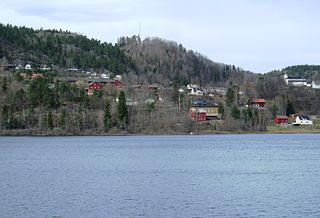
Åmli is the administrative centre of Åmli municipality in Aust-Agder county, Norway. The village is located along the Norwegian National Road 41 and the river Nidelva, about 30 kilometres (19 mi) northwest of the town of Tvedestrand via the Norwegian County Road 415. The village of Nelaug lies about 15 kilometres (9.3 mi) to the southeast and the village of Dølemo lies about 10 kilometres (6.2 mi) to the southwest. The 0.8-square-kilometre (200-acre) village has a population (2017) of 682 which gives the village a population density of 853 inhabitants per square kilometre (2,210/sq mi).

Vegårshei Church is a parish church in Vegårshei municipality in Aust-Agder county, Norway. It is located in the village of Myra. It is the church for the Vegårshei parish which is part of the Aust-Nedenes prosti (deanery) in the Diocese of Agder og Telemark. The white, wooden, cruciform church was built in a Louis XVI style in 1808 by the architect Knud Torkildsen Skjerkholt. The church seats about 350 people. It was consecrated on 19 August 1810 and it replaced an older church that was built during the 1600s.


