Wolica is a village in Poland located in Lesser Poland Voivodeship, in Bochnia County, in Gmina Łapanów. It had a population of 230 in 2005. It lies approximately 3 kilometres (2 mi) west of Łapanów, 19 km (12 mi) south-west of Bochnia, and 33 km (21 mi) south-east of the regional capital Kraków.
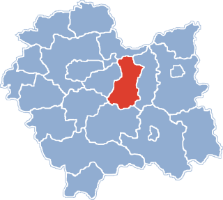
Gmina Trzciana is a rural gmina in Bochnia County, Lesser Poland Voivodeship, in southern Poland. Its seat is the village of Trzciana, which lies approximately 16 kilometres (10 mi) south of Bochnia and 39 km (24 mi) south-east of the regional capital Kraków.

Buczyna is a village in the administrative district of Gmina Bochnia, within Bochnia County, Lesser Poland Voivodeship, in southern Poland. It lies approximately 11 kilometres (7 mi) south-west of Bochnia and 33 km (21 mi) south-east of the regional capital Kraków.
Moszczenica is a village in the administrative district of Gmina Bochnia, within Bochnia County, Lesser Poland Voivodeship, in southern Poland. It lies approximately 9 kilometres (6 mi) south-west of Bochnia and 31 km (19 mi) south-east of the regional capital Kraków.

Nieszkowice Małe is a village in the administrative district of Gmina Bochnia, within Bochnia County, Lesser Poland Voivodeship, in southern Poland. It lies approximately 11 kilometres (7 mi) south-west of Bochnia and 31 km (19 mi) south-east of the regional capital Kraków.
Siedlec is a village in the administrative district of Gmina Bochnia, within Bochnia County, Lesser Poland Voivodeship, in southern Poland. It lies approximately 10 kilometres (6 mi) south-west of Bochnia and 30 km (19 mi) south-east of the regional capital Kraków.
Boczów is a village in the administrative district of Gmina Łapanów, within Bochnia County, Lesser Poland Voivodeship, in southern Poland. It lies approximately 2 kilometres (1 mi) south of Łapanów, 18 km (11 mi) south-west of Bochnia, and 35 km (22 mi) south-east of the regional capital Kraków.
Brzezowa is a village in the administrative district of Gmina Łapanów, within Bochnia County, Lesser Poland Voivodeship, in southern Poland. It lies approximately 17 kilometres (11 mi) south-west of Bochnia and 34 km (21 mi) south-east of the regional capital Kraków.
Chrostowa is a village in the administrative district of Gmina Łapanów, within Bochnia County, Lesser Poland Voivodeship, in southern Poland. It lies approximately 6 kilometres (4 mi) north of Łapanów, 12 km (7 mi) south-west of Bochnia, and 32 km (20 mi) south-east of the regional capital Kraków.
Cichawka is a village in the administrative district of Gmina Łapanów, within Bochnia County, Lesser Poland Voivodeship, in southern Poland. It lies approximately 6 kilometres (4 mi) east of Łapanów, 13 km (8 mi) south-west of Bochnia, and 37 km (23 mi) south-east of the regional capital Kraków.
Grabie is a village in the administrative district of Gmina Łapanów, within Bochnia County, Lesser Poland Voivodeship, in southern Poland. It lies approximately 4 kilometres (2 mi) south-west of Łapanów, 20 km (12 mi) south-west of Bochnia, and 34 km (21 mi) south-east of the regional capital Kraków.
Kamyk is a village in the administrative district of Gmina Łapanów, within Bochnia County, Lesser Poland Voivodeship, in southern Poland. It lies approximately 4 kilometres (2 mi) north of Łapanów, 13 km (8 mi) south-west of Bochnia, and 33 km (21 mi) south-east of the regional capital Kraków.

Łapanów is a village in Bochnia County, Lesser Poland Voivodeship, in southern Poland. It is the seat of the gmina called Gmina Łapanów. It lies approximately 17 kilometres (11 mi) south-west of Bochnia and 34 km (21 mi) south-east of the regional capital Kraków.
Lubomierz is a village in the administrative district of Gmina Łapanów, within Bochnia County, Lesser Poland Voivodeship, in southern Poland. It lies approximately 3 kilometres (2 mi) west of Łapanów, 18 km (11 mi) south-west of Bochnia, and 32 km (20 mi) south-east of the regional capital Kraków.

Sobolów is a village in the administrative district of Gmina Łapanów, within Bochnia County, Lesser Poland Voivodeship, in southern Poland. It lies approximately 7 kilometres (4 mi) north-east of Łapanów, 10 km (6 mi) south-west of Bochnia, and 34 km (21 mi) south-east of the regional capital Kraków.
Tarnawa is a village in the administrative district of Gmina Łapanów, within Bochnia County, Lesser Poland Voivodeship, in southern Poland. It lies approximately 4 kilometres (2 mi) south of Łapanów, 20 km (12 mi) south-west of Bochnia, and 37 km (23 mi) south-east of the regional capital Kraków. The village is also 62 km (39 mi) south-west away from the Tarnów City. Tarnawa had previously been in the Tarnów Voivodeship (1975–1998).

Wieruszyce is a village in the administrative district of Gmina Łapanów, within Bochnia County, Lesser Poland Voivodeship, in southern Poland. It lies approximately 3 kilometres (2 mi) south-east of Łapanów, 17 km (11 mi) south-west of Bochnia, and 36 km (22 mi) south-east of the regional capital Kraków.
Wola Wieruszycka is a village in the administrative district of Gmina Łapanów, within Bochnia County, Lesser Poland Voivodeship, in southern Poland. It lies approximately 3 kilometres (2 mi) north-east of Łapanów, 14 km (9 mi) south-west of Bochnia, and 34 km (21 mi) south-east of the regional capital Kraków.
Zbydniów is a village in the administrative district of Gmina Łapanów, within Bochnia County, Lesser Poland Voivodeship, in southern Poland. It lies approximately 4 kilometres (2 mi) south of Łapanów, 19 km (12 mi) south-west of Bochnia, and 38 km (24 mi) south-east of the regional capital Kraków.