Located in the Yauyos Province of the Lima Region in central Peru, Qaqa Mach'ay is a limestone cave high in the Andes Mountains that was explored and surveyed in 2004 by an international expedition. At 4,930m above sea level, it is the highest surveyed cave in the world. The entrance to the cave is in the mountain named Wamp'una.

The Yauyos Province is a province located in the Lima Region of Peru. It is one of the eleven that make up that region.

Laraos District is one of thirty-three districts of the province Yauyos in the Lima Region in Peru.
Tanta District is one of thirty-three districts of the province Yauyos in Peru. Its seat is the village Tanta.
The Nor Yauyos-Cochas Landscape Reserve is a protected area in Peru located in the Lima Region, Yauyos Province and in the Junín Region, Jauja Province. It lies with the Peruvian Yungas and Central Andean wet puna ecoregions.
Lake Pumacocha is a lake in Peru located in Laraos District, Yauyos Province, Lima. It has an elevation of 4,388 m and about 2 km long. Sima Pumaqucha which is considered the deepest cave in the Andes is located near the lake.
Ticllacocha is a lake in Peru located in the Lima Region, Yauyos Province, Tanta District. It is situated at a height of about 4,475 metres (14,682 ft), south of the lakes Paucarcocha, Chuspicocha and Piscococha and northwest of the mountains Ticlla and Huayna Cotoni.

Ticlla or Qutuni, also called Tiklla or Tiqlla, is a 5,897-metre-high (19,347 ft) mountain in the Cordillera Central in the Andes of Peru. Strictly speaking the popular name Ticlla refers to a group of peaks of the Qutuni-Ticlla cirque. The highest mountain of the massif is named Qutuni. It lies in a sub-range of the Cordillera Central named Pichqa Waqra.

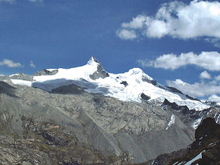
Wamp'una is a mountain in the Cordillera Central in the Andes of Peru, about 5,000 metres (16,404 ft) high. It contains one of the highest surveyed caves in the word, Qaqa Mach'ay. Wamp'una is located in the Lima Region, Yauyos Province, on the border of the districts of Huantán and Laraos. It lies southwest of T'uruyuq, southeast of the lake named Pumaqucha. It is situated on the southern border of the Nor Yauyos-Cochas Landscape Reserve.
Huayna Cotoni or Wayna Qutuni(Aymara wayna young, bachelor, qutu heap, pile, -ni a suffix to indicate ownership, Qutuni a neighboring mountain, "young Qutuni", Hispanicized spellings Huayna Cotoni, Huaynacotoni, Huaynacutuni) is a mountain in the Cordillera Central in the Andes of Peru, about 5,463 metres (17,923 ft) high. It is located in the Lima Region, Yauyos Province, on the border of the districts of Ayaviri, Quinches and Tanta. Huayna Cotoni is in a sub-range of the Cordillera Central named Pichqa Waqra on the southern border of the Nor Yauyos-Cochas Landscape Reserve. It lies between the lakes named Tikllaqucha in the north and Huayna Cotoni in the south, southwest of the peak of Qutuni and south of Aqupallqa.
Challwaqucha may refer to:
Aqupallqa is a mountain in the Cordillera Central in the Andes of Peru, about 5,445 metres (17,864 ft) high. It is situated in the Lima Region, Yauyos Province, Tanta District. Aqupallqa lies north of the mountain Wayna Qutuni and the lake Tikllaqucha and northwest of the mountain Qutuni.
Uchku Mach'ay is a mountain in the Andes of Peru which reaches a height of approximately 4,000 m (13,000 ft). It lies in the Junín Region, Tarma Province, Tarma District.
Muki is a mountain in the Cordillera Central in the Andes of Peru which reaches a height of approximately 4,800 metres (15,748 ft). It is located in the Lima Region, Yauyos Province, Tanta District. Muki lies northwest of Paqarin Pawka at a lake named Ch'uspiqucha.
Yana P'unqu is mountain Cordillera Central in the Andes of Peru which reaches a height of approximately 4,800 metres (15,748 ft). It is located in the Lima Region, Yauyos Province, Laraos District. Yana P'unqu lies north of a lake named Pumaqucha.
Yana Urqu is mountain in the Cordillera Central in the Andes of Peru which reaches a height of approximately 4,800 metres (15,748 ft). It is located in the Lima Region, Yauyos Province, Laraos District. Yana Urqu lies northwest of Uchku and a lake named Pumaqucha.
Winsu is mountain in the Cordillera Central in the Andes of Peru which reaches a height of approximately 5,000 metres (16,404 ft). It is located in the Lima Region, Yauyos Province, on the border of the districts of Miraflores and Vitis.
Muki is a mountain in the Cordillera Central in the Andes of Peru which reaches a height of approximately 4,800 metres (15,748 ft). It is located in the Lima Region, Yauyos Province, on the border of the districts of Huancaya and Tomas.


