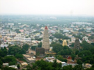
Mangalagiri is a major Sub-urban of Vijayawada in Guntur district of Indian state of Andhra Pradesh. The town is a part of Mangalagiri Tadepalli Municipal Corporation and part of Tenali revenue division. It and a part of Andhra Pradesh Capital Region. It is situated on National Highway 16 between Vijayawada and Guntur.
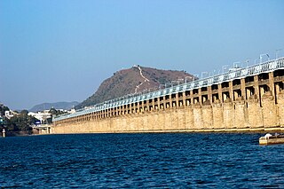
Vijayawada, is the second largest city and commercial hub in the Indian state of Andhra Pradesh. The city is part of the Andhra Pradesh Capital Region and is located on the banks of the Krishna River surrounded by the hills of the Eastern Ghats, known as the Indrakeeladri Hills. The city is home to the important Hindu shrine of Kanaka Durga Temple. It geographically lies on the center spot of Andhra Pradesh. The city has been described as the commercial, political, cultural and educational capital of Andhra Pradesh. It is the administrative headquarters of NTR district. The Prakasam Barrage across the Krishna River connects the NTR and Guntur districts.
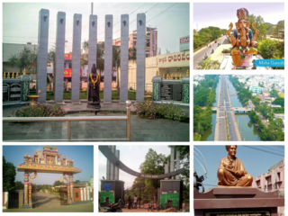
Tenali is a city in Guntur district of the Indian state of Andhra Pradesh. It is a municipality, and the headquarters of Tenali mandal and Tenali revenue division. The city is renowned for art, culture, drama, and hence, it is called Andhra Paris. It is one of the twelve urban local bodies in Andhra Pradesh Capital Region and the twelfth most populous town in the state, with a population of 199,345 as of 2011. Tenali town is also part of Andhra Pradesh Capital Region Development Authority (APCRDA).

Amaravathi is a village on the banks of the Krishna River, in the Palnadu district of the Indian state of Andhra Pradesh. It is the headquarters of Amaravathi mandal, and forms part of the Andhra Pradesh Capital Region with its headquarters at new Amaravati 35 km (22 mi) east, whose name is also borrowed from that of the older Amaravathi.
Guntur is a city in the Indian state of Andhra Pradesh and the administrative headquarters of Guntur district. The city is part of the Andhra Pradesh Capital Region and is located on the Eastern Coastal Plains approximately 30 kilometres (19 mi) south of the state capital Amaravati. According to data from the 2011 Census of India, Guntur had a population of 743,354 in that year, making it the third-most-populous city in the state, and occupies 159.46 square kilometres of land.

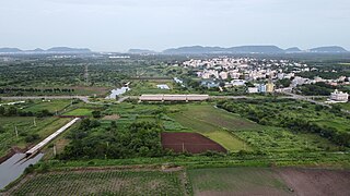
Thulluru is a Village in Guntur district of Indian state of Andhra Pradesh. It is located at a distance of 4 km from Krishna River and was a village in Thulluru mandal of Guntur district, prior to its denotification as gram panchayat.
Rayapudi is a neighbourhood and a part of Urban Notified Area of Amaravati, the state capital of the Indian state of Andhra Pradesh. It was a village in Thullur mandal of in Guntur district, prior to its denotification as gram panchayat.

Venkatapalem is a neighbourhood and a part of Urban Notified Area of Amaravati, the state capital of the Indian state of Andhra Pradesh. It was a village in Thullur mandal of Guntur district, prior to its denotification as gram panchayat.
Anantavaram is a neighbourhood and a part of Urban Notified Area of Amaravati, the state capital of the Indian state of Andhra Pradesh. It was a village in Thullur mandal of Guntur district, prior to its denotification as gram panchayat.
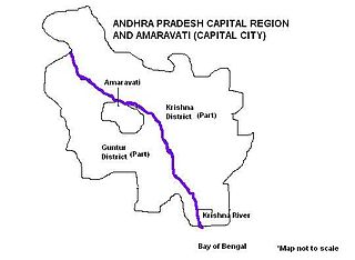
Andhra Pradesh Capital Region is the metropolitan area of the capital city Amaravati of Andhra Pradesh in India. The region is spread across the districts of NTR, Krishna, Guntur, Palnadu, Bapatla and Eluru. It includes the major ancient cities of Vijayawada, Guntur and Tenali. Vijayawada is the largest city and headquarters of the region. It is one the most populated metropolitan areas in Andhra Pradesh. The region is under the jurisdiction of Andhra Pradesh Capital Region Development Authority and covers an area of 8,352.69 km2 (3,224.99 sq mi) under 58 mandals . The capital city Amaravati is an urban notified area and will cover 217.23 km2 (83.87 sq mi), within the Andhra Pradesh Capital Region.

Thullur mandal is one of the 18 mandals in Guntur district of the Indian state of Andhra Pradesh. It is under the administration of Guntur Revenue Division and the headquarters are located at Thullur. The mandal is situated on the banks of Krishna River, bounded by Amaravathi, Tadikonda, Tadepalle and Mangalagiri mandals. The mandal is also a part of the new capital city of Andhra Pradesh to be developed. 18 villages from the mandal fall under the jurisdiction of Andhra Pradesh Capital City.

The Andhra Pradesh Capital Region Development Authority, Amaravati, ACT No. 27 of 2020. It was notified on 31 July 2020 by the Government of Andhra Pradesh as per The Andhra Pradesh Capital Region Development Authority Repeal Act, 2020, it replaced the Andhra Pradesh Capital Region Development Authority Act, 2014. The authority has a jurisdictional area of 8,352.69 km2, covering the districts of Guntur, Eluru, NTR, Krishna, Palnadu, and Bapatla.
Amaravati is the capital city of the Indian state of Andhra Pradesh. It is situated at the heart of the state, on the right bank of the river Krishna in Guntur district. It is near to Dharanikota, the ancient city site nearby, that served as the capital of Satavahana dynasty more than 2,200 years ago. The Andhra Pradesh Capital Region encompasses the cities of Guntur, and Vijayawada.
Undavalli is a southern neighbourhood of Vijayawada city of the Indian state of Andhra Pradesh. It was a village in Tadepalle mandal of Guntur district, prior to its de-notification as gram panchayat. 5th century Buddhist and Hindu Undavalli Caves which signify Monolithic Indian rock-cut architecture are present at this place. It is a part of Vijayawada Urban Agglomeration.
Velagapudi is a village in Guntur district of the Indian state of Andhra Pradesh. It was a village in Thullur mandal of Guntur district, prior to its denotification as Gram Panchayat. Velagapudi is also the home to the temporary Secretariat of Andhra Pradesh.
Mandadam is a Village in Guntur district in Indian state of Andhra Pradesh. It was a village in Thullur mandal of Guntur district, prior to its denotification as gram panchayat.

Borupalem is a neighbourhood and a part of Urban Notified Area of Amaravati, the state capital of the Indian state of Andhra Pradesh. It was a village in Thullur mandal of in Guntur district, prior to its denotification as gram panchayat.

Vykuntapuram, also spelled as Vaikuntapuram, is a village in Guntur district of the Indian state of Andhra Pradesh. It is located in Amaravathi mandal of Guntur revenue division. The village forms a part of Andhra Pradesh Capital Region, under the jurisdiction of APCRDA.
Lingayapalem is a neighbourhood and a part of Urban Notified Area of Amaravati, the state capital of the Indian state of Andhra Pradesh. It was a village in Thullur mandal of in Guntur district, prior to its denotification as gram panchayat.
Abbarajupalem is a neighbourhood and a part of Urban Notified Area of Amaravati, the state capital of the Indian state of Andhra Pradesh. It was a village in Thullur mandal of in Guntur district, prior to its denotification as gram panchayat.
