Ulla Ulla Airport

Last updated
Ulla Ulla Airport
Franz Tamayo Airport
Summary
Airport type Public
Serves Ulla Ulla
Elevation  AMSL 14,360 ft / 4,377 m
Coordinates 15°02′10″S69°15′20″W / 15.03611°S 69.25556°W / -15.03611; -69.25556 (Franz Tamayo Airport (Ulla Ulla)) Coordinates: 15°02′10″S69°15′20″W / 15.03611°S 69.25556°W / -15.03611; -69.25556 (Franz Tamayo Airport (Ulla Ulla))
Map
Bolivia adm location map.svg
Airplane silhouette.svg
SLUU
Location of Franz Tamayo Airport in Bolivia
Runways
Direction Length Surface
m ft
08/26 1,300 4,265 Dirt
Source: Landings.com [1] Google Maps [2] GCM [3]

Ulla Ulla Airport( ICAO : SLUU) is an extremely-high elevation airport 3 kilometres (1.9 mi) north of Ulla Ulla village in the La Paz Department of Bolivia. Ulla Ulla is close to the Peruvian border north of Lake Titicaca.

ICAO airport code four-letter code designating many airports around the world

The ICAOairport code or location indicator is a four-letter code designating aerodromes around the world. These codes, as defined by the International Civil Aviation Organization and published in ICAO Document 7910: Location Indicators, are used by air traffic control and airline operations such as flight planning.

Bolivia country in South America

Bolivia, officially the Plurinational State of Bolivia is a landlocked country located in western-central South America. The capital is Sucre while the seat of government and financial center is located in La Paz. The largest city and principal industrial center is Santa Cruz de la Sierra, located on the Llanos Orientales a mostly flat region in the east of Bolivia.

Peru republic in South America

Peru, officially the Republic of Peru, is a country in western South America. It is bordered in the north by Ecuador and Colombia, in the east by Brazil, in the southeast by Bolivia, in the south by Chile, and in the west by the Pacific Ocean. Peru is a megadiverse country with habitats ranging from the arid plains of the Pacific coastal region in the west to the peaks of the Andes mountains vertically extending from the north to the southeast of the country to the tropical Amazon Basin rainforest in the east with the Amazon river.

Contents

While the entire region is mountainous, the airport is on an alluvial fan of the Cordillera Apolobamba mountains, with no hazardous terrain nearby. It also shares use as a road.

Alluvial fan A fan- or cone-shaped deposit of sediment crossed and built up by streams

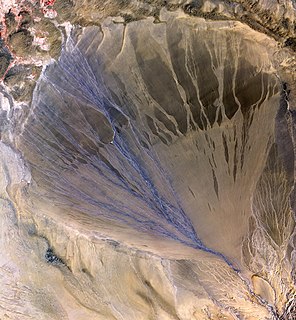
Alluvial fans are triangular-shaped deposits of water-transported material, often referred to as alluvium. They are an example of an unconsolidated sedimentary deposit and tend to be larger and more prominent in arid to semi-arid regions. These alluvial fans typically form in elevated or even mountainous regions where there is a rapid change in slope from a high to low gradient. The river or stream carrying the sediment flows at a relatively high velocity due to the high slope angle which is why coarse material is able to remain in the flow. When the slope decreases rapidly into a relatively plain or plateau, the stream loses the energy it needs to move its sediment. Deposition subsequently occurs and the sediment ultimately spreads out, creating an alluvial fan. Three primary zones occur within an alluvial fan which includes the proximal fan, medial fan, and the distal fan.

Cordillera Apolobamba mountain range

Apolobamba(Cordillera Apolobamba) is a mountain range in the South American Andes.

See also

Transport in Bolivia is mostly by road. The railways were historically important in Bolivia, but now play a relatively small part in the country's transport system. Because of the country's geography, aviation is also important.

Related Research Articles

Angora Airport

Angora Airport is an airstrip 64 kilometres (40 mi) north-northwest of San Ignacio de Moxos in the Beni Department of Bolivia.

Ixiamas Airport

Ixiamas Airport is an airport serving the town of Ixiamas in the La Paz Department of Bolivia.

Santiago Airport (Bolivia)

Santiago Airport is a rural airport 33 kilometres (21 mi) southeast of San Ignacio de Moxos in the Beni Department of Bolivia.

Coquinal Airport

Coquinal Airport is an airstrip in the pampa of Beni Department in Bolivia. The runway is off a minor road bordering the wetlands around the Beni River.

El Remate Airport

El Remate Airport is an airstrip 7 kilometres (4.3 mi) northwest of Santa Rosa del Sara (de) in the Santa Cruz Department of Bolivia.

Las Brizas Airport

Las Brizas Airport is an airstrip serving the village of Las Brizas on the headwaters of the Matos River in the Beni Department of Bolivia.

Intiraymi Airport

Intiraymi Airport is an extremely high elevation airport serving the Franklin Mining, Inc. silver and gold mining concession at La Joya in the Oruro Department of Bolivia.

Manuripi Airport

Manuripi Airport is an airstrip serving the settlement of Manuripi on the Manuripi River in the Pando Department of Bolivia.

Padilla Airport

Padilla Airport is an airport just north of the town of Padilla in the Chuquisaca Department of Bolivia.

Pitai Airport

Pitai Airport is an airstrip in the sparsely populated Bolivian pampa of the Beni Department of Bolivia.

Progreso Airport

Progreso Airport is an airport serving the Apere River village of Progreso in the Beni Department of Bolivia.

Rancho Alegre Airport

Rancho Alegre Airport is an airstrip serving Rancho Alegre, a ranch in the Beni Department of Bolivia.

Rosal Airport

Rosal Airport is an airstrip serving Rosal in the Beni Department of Bolivia.

San Miguel South Airport

San Miguel South Airport is an airport serving San Miguel de Velasco in the Santa Cruz Department of Bolivia. The runway is on the south edge of the town.

San Miguel de Gaser Airport

San Miguel de Gaser Airport is a public use airport located near Sipuati, Beni, Bolivia.

Sipuati Airport

Sipuati Airport is a public use airport near Sipuati in the Tarija Department of Bolivia.

Taquipirenda Airport

Taquipirenda Airport is a public-use airstrip serving the Taquipirenda gas pipeline facility in the Santa Cruz Department of Bolivia.

San Vicente Airport (Bolivia)

San Vicente Airport is an airstrip 1 kilometre (0.62 mi) west of San Vicente, in the Santa Cruz Department of Bolivia. The town is on the border with Brazil.

Santa Teresita Airport (Bolivia)

Santa Teresita Airport is a public use airport serving Santa Teresita in the Santa Cruz Department of Bolivia. Santa Teresita is a border crossing point with Brazil.

Toldos Airport

Toldos Airport is a high-elevation airport serving the San Cristóbal silver mine and its supporting town in the Potosí Department of Bolivia. San Cristóbal is within the Bolivian Altiplano, and there is high terrain north and south of the runway.

References

  1. Airport record for Franz Tamayo Airport at Landings.com. Retrieved 2013-08-21
  2. Google (2013-08-21). "location of Ulla Ulla Airport" (Map). Google Maps . Google. Retrieved 2013-08-21.
  3. Airport information for Ulla Ulla Airport at Great Circle Mapper.

The Aviation Safety Network (ASN) is a website that keeps track of aviation accidents, incidents, and hijackings. Their database contains details of over 10,700 reports. The ASN includes an aviation database with aviation investigations, news, photos, and statistics.