
The asthenosphere is the mechanically weak and ductile region of the upper mantle of Earth. It lies below the lithosphere, at a depth between ~80 and 200 km below the surface, and extends as deep as 700 km (430 mi). However, the lower boundary of the asthenosphere is not well defined.
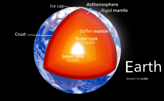
Earth's outer core is a fluid layer about 2,260 km (1,400 mi) thick, composed of mostly iron and nickel that lies above Earth's solid inner core and below its mantle. The outer core begins approximately 2,889 km (1,795 mi) beneath Earth's surface at the core-mantle boundary and ends 5,150 km (3,200 mi) beneath Earth's surface at the inner core boundary.

A mantle plume is a proposed mechanism of convection within the Earth's mantle, hypothesized to explain anomalous volcanism. Because the plume head partially melts on reaching shallow depths, a plume is often invoked as the cause of volcanic hotspots, such as Hawaii or Iceland, and large igneous provinces such as the Deccan and Siberian Traps. Some such volcanic regions lie far from tectonic plate boundaries, while others represent unusually large-volume volcanism near plate boundaries.
Earth's mantle is a layer of silicate rock between the crust and the outer core. It has a mass of 4.01 × 1024 kg and thus makes up 67% of the mass of Earth. It has a thickness of 2,900 kilometers (1,800 mi) making up about 84% of Earth's volume. It is predominantly solid but, on geologic time scales, it behaves as a viscous fluid, sometimes described as having the consistency of caramel. Partial melting of the mantle at mid-ocean ridges produces oceanic crust, and partial melting of the mantle at subduction zones produces continental crust.

The core–mantle boundary (CMB) of Earth lies between the planet's silicate mantle and its liquid iron-nickel outer core. This boundary is located at approximately 2,891 km depth beneath Earth's surface. The boundary is observed via the discontinuity in seismic wave velocities at that depth due to the differences between the acoustic impedances of the solid mantle and the molten outer core. P-wave velocities are much slower in the outer core than in the deep mantle while S-waves do not exist at all in the liquid portion of the core. Recent evidence suggests a distinct boundary layer directly above the CMB possibly made of a novel phase of the basic perovskite mineralogy of the deep mantle named post-perovskite. Seismic tomography studies have shown significant irregularities within the boundary zone and appear to be dominated by the African and Pacific Large Low-Shear-Velocity Provinces (LLSVP).

A large igneous province (LIP) is an extremely large accumulation of igneous rocks, including intrusive and extrusive, arising when magma travels through the crust towards the surface. The formation of LIPs is variously attributed to mantle plumes or to processes associated with divergent plate tectonics. The formation of some of the LIPs in the past 500 million years coincide in time with mass extinctions and rapid climatic changes, which has led to numerous hypotheses about causal relationships. LIPs are fundamentally different from any other currently active volcanoes or volcanic systems.

The Iceland hotspot is a hotspot which is partly responsible for the high volcanic activity which has formed the Iceland Plateau and the island of Iceland.
Earth's inner core is the innermost geologic layer of planet Earth. It is primarily a solid ball with a radius of about 1,220 km (760 mi), which is about 20% of Earth's radius or 70% of the Moon's radius.
Ferropericlase or magnesiowüstite is a magnesium/iron oxide with the chemical formula (Mg,Fe)O that is interpreted to be one of the main constituents of the Earth's lower mantle together with the silicate perovskite, a magnesium/iron silicate with a perovskite structure. Ferropericlase has been found as inclusions in a few natural diamonds. An unusually high iron content in one suite of diamonds has been associated with an origin from the lowermost mantle. Discrete ultralow-velocity zones in the deepest parts of the mantle, near the Earth's core, are thought to be blobs of ferropericlase, as seismic waves are significantly slowed as they pass through them, and ferropericlase is known to have this effect at the high pressures and temperatures found deep within the Earth's mantle. In May 2018, ferropericlase was shown to be anisotropic in specific ways in the high pressures of the lower mantle, and these anisotropies may help seismologists and geologists to confirm whether those ultra-low velocity zones are indeed ferropericlase, by passing seismic waves through them from various different directions and observing the exact amount of change in the velocity of those waves.

The Marquesas hotspot is a volcanic hotspot in the southern Pacific Ocean. It is responsible for the creation of the Marquesas Islands – a group of eight main islands and several smaller ones – and a few seamounts. The islands and seamounts formed between 5.5 and 0.4 million years ago and constitute the northernmost volcanic chain in French Polynesia.
The Society hotspot is a volcanic hotspot in the south Pacific Ocean which is responsible for the formation of the Society Islands, an archipelago of fourteen volcanic islands and atolls spanning around 720 km of the ocean which formed between 4.5 and <1 Ma.

The low-velocity zone (LVZ) occurs close to the boundary between the lithosphere and the asthenosphere in the upper mantle. It is characterized by unusually low seismic shear wave velocity compared to the surrounding depth intervals. This range of depths also corresponds to anomalously high electrical conductivity. It is present between about 80 and 300 km depth. This appears to be universally present for S waves, but may be absent in certain regions for P waves. A second low-velocity zone has been detected in a thin ≈50 km layer at the core-mantle boundary. These LVZs may have important implications for plate tectonics and the origin of the Earth's crust.
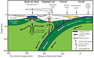
A mantle wedge is a triangular shaped piece of mantle that lies above a subducting tectonic plate and below the overriding plate. This piece of mantle can be identified using seismic velocity imaging as well as earthquake maps. Subducting oceanic slabs carry large amounts of water; this water lowers the melting temperature of the above mantle wedge. Melting of the mantle wedge can also be contributed to depressurization due to the flow in the wedge. This melt gives rise to associated volcanism on the earth's surface. This volcanism can be seen around the world in places such as Japan and Indonesia.

Large low-shear-velocity provinces, LLSVPs, also called LLVPs or superplumes, are characteristic structures of parts of the lowermost mantle of Earth. These provinces are characterized by slow shear wave velocities and were discovered by seismic tomography of deep Earth. There are two main provinces: the African LLSVP and the Pacific LLSVP. Both extend laterally for thousands of kilometers and possibly up to 1,000 kilometers vertically from the core–mantle boundary. The Pacific LLSVP is 3,000 kilometers across, and underlies four hotspots that suggest multiple mantle plumes underneath. These zones represent around 8% of the volume of the mantle. Other names for LLSVPs include "superswells", "thermo-chemical piles", or "hidden reservoirs". Most of these names, however, are more interpretive of their proposed geodynamical or geochemical effects. For example, the name "thermo-chemical pile" interprets LLSVPs as lower-mantle piles of thermally hot and/or chemically distinct material. LLSVPs are still relatively mysterious, and many questions remain about their nature, origin, and geodynamic effects.
The Skagerrak-Centered Large Igneous Province (SCLIP), also known as the European-Northwest African Large Igneous Province (EUNWA), and Jutland LIP, is a 300 million year old (Ma) large igneous province (LIP) centered on what is today the Skagerrak strait in north-western Europe. It was named by Torsvik et al. 2008.

The deep water cycle, or geologic water cycle, involves exchange of water with the mantle, with water carried down by subducting oceanic plates and returning through volcanic activity, distinct from the water cycle process that occurs above and on the surface of Earth. Some of the water makes it all the way to the lower mantle and may even reach the outer core. Mineral physics experiments show that hydrous minerals can carry water deep into the mantle in colder slabs and even "nominally anhydrous minerals" can store several oceans' worth of water.

The deep carbon cycle is geochemical cycle (movement) of carbon through the Earth's mantle and core. It forms part of the carbon cycle and is intimately connected to the movement of carbon in the Earth's surface and atmosphere. By returning carbon to the deep Earth, it plays a critical role in maintaining the terrestrial conditions necessary for life to exist. Without it, carbon would accumulate in the atmosphere, reaching extremely high concentrations over long periods of time.
The lower mantle, historically also known as the mesosphere, represents approximately 56% of Earth's total volume, and is the region from 660 to 2900 km below Earth's surface; between the transition zone and the outer core. The preliminary reference Earth model (PREM) separates the lower mantle into three sections, the uppermost (660–770 km), mid-lower mantle (770–2700 km), and the D layer (2700–2900 km). Pressure and temperature in the lower mantle range from 24–127 GPa and 1900–2600 K. It has been proposed that the composition of the lower mantle is pyrolitic, containing three major phases of bridgmanite, ferropericlase, and calcium-silicate perovskite. The high pressure in the lower mantle has been shown to induce a spin transition of iron-bearing bridgmanite and ferropericlase, which may affect both mantle plume dynamics and lower mantle chemistry.

Kevin C. A. Burke was a geologist known for his contributions in the theory of plate tectonics. In the course of his life, Burke held multiple professorships, most recent of which (1983-2018) was the position of professor of geology and tectonics at the Department of Earth and Atmospheric Science, University of Houston. His studies on plate tectonics, deep mantle processes, sedimentology, erosion, soil formation and other topics extended over several decades and influenced multiple generations of geologists and geophysicists around the world.
Intraplate volcanism is volcanism that takes place away from the margins of tectonic plates. Most volcanic activity takes place on plate margins, and there is broad consensus among geologists that this activity is explained well by the theory of plate tectonics. However, the origins of volcanic activity within plates remains controversial.
