Sandaun Province is the northwesternmost province of Papua New Guinea. It covers an area of 35,920 km2 and has a population of 248,411. The capital is Vanimo. In July 1998 the area surrounding the town Aitape was hit by an enormous tsunami caused by a Magnitude 7.0 earthquake which killed over 2,000 people. The five villages along the west coast of Vanimo towards the International Border are namely; Lido, Waromo, Yako, Musu and Wutung.

This page is a list of local-level governments (LLGs) of Papua New Guinea. There are 326 LLGs comprising 6,112 wards as of 2018.
The Kavieng Urban LLG is a local government area in New Ireland Province, Papua New Guinea. The LLG is located in Kavieng District and the LLG headquarters is Kavieng. This LLG has six wards. The area is a renowned habitat for the nutria or giant rat. The population is 16,725 and the Lord Mayor is Hon. Stanley Mansini MPA.
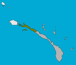
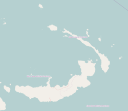
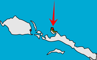
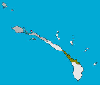
Tikana Rural LLG is a local government area in New Ireland Province, Papua New Guinea. The LLG administers the northern section of the island of New Ireland, as well as Djaul Island and some Tigak islands in the strait between New Ireland and New Hanover.

Lovongai Rural LLG is a local government area in New Ireland Province, Papua New Guinea. The LLG administers the island of New Hanover and a few surrounding islands. The LLG is located in Kavieng District and the LLG headquarters is Taskul. Some population centres in the LLG are: Taskul, Patiagaga, Patipai, Ungakum, Tsoi, Tukulisava, and Ungalik. This LLG has 19 wards, comprising a population of 29,005. Current LLG President is John Aini.

Murat Rural LLG is a local government area in New Ireland Province, Papua New Guinea. The LLG president is Herman Sole. The LLG administers the St. Matthias Group of islands and is located in Kavieng District. Population is 4,210(Census 2011).
Namatanai Rural LLG is a local government area in New Ireland Province, Papua New Guinea. The LLG is located in Namatanai District and the LLG headquarters is Namatanai.
Konoagil Rural LLG is a local government area in New Ireland Province, Papua New Guinea. The LLG administers the southern peninsula of the island of New Ireland. The LLG is located in Namatanai District and its population is 10,503. Languages in the area are Siar-Lak language, Kandas language, and Label language.
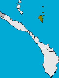
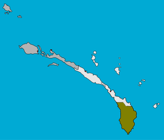
Nimamar Rural LLG is a local government area in New Ireland Province, Papua New Guinea. The LLG administers the Lihir Group of islands. The LLG is located in Namatanai District and contains the Lihir Gold Mine, which is the second largest gold deposit in the world. Main language spoken here is the Lihir language. Many speakers of other languages are present here due to the mining on the island. Commonly are Niwer Mil language, Kuanua language and Mandara language.

Labur is a village on the west coast of New Ireland, Papua New Guinea. It is located to the south of Kalagunan, on Labur Bay. It is located in Namatanai Rural LLG.
Rasirik is a village on the west coast of New Ireland, Papua New Guinea. It is located to the south of Labur. The government has exploited timber reserves in the area. It is located in Namatanai Rural LLG.
Palabong is a village on the south-west coast of New Ireland, Papua New Guinea. It is located to the southeast of Umudu. It is located in Namatanai Rural LLG.
Nokon is a village on the south-eastern coast of New Ireland, Papua New Guinea. According to Alexander H. Bolyanatz, "Tekedan, Himaul, and Nokon form something of a sociological cluster." It contains a United Church. It is located in Namatanai Rural LLG.

East Aitape Rural LLG is a local-level government (LLG) of Sandaun Province, Papua New Guinea. Arapesh and Schouten languages are spoken in this LLG.
Amanab Rural LLG is a local-level government (LLG) of Sandaun Province, Papua New Guinea. It is located along the border with Keerom Regency, Papua Province, Indonesia.
Wampar Rural LLG is a local-level government (LLG) located in the Markham Valley of Morobe Province, Papua New Guinea. The Wampar language is spoken in the LLG, along with Labu, Yalu (Aribwaung), Watut, and other Markham languages.
Wau-Bulolo Urban LLG is a local-level government (LLG) located in the Bulolo Valley of Morobe Province, Papua New Guinea.
Kainantu Urban LLG is a local-level government (LLG) of Eastern Highlands Province, Papua New Guinea. Ukarumpa, an important SIL International base in Papua New Guinea, is located in the LLG.

Inland Baining Rural LLG is a local-level government (LLG) located in the Baining Mountains of East New Britain Province, Papua New Guinea.
Lake Kutubu Rural LLG is a local-level government (LLG) of Southern Highlands Province, Papua New Guinea. Kutubuan languages are spoken in the LLG.