
The Merrick, or simply Merrick, is a mountain in the Range of the Awful Hand, a sub-range of the Galloway Hills range, part of the Southern Uplands of Scotland. The summit elevation is 843 metres, making it the highest mountain in the Southern Uplands and southern Scotland.

Broad Law is a hill in the Manor Hills range, part of the Southern Uplands of Scotland. The second-highest point in the Southern Uplands and the highest point in the Scottish Borders, it has an elevation of 840 metres, a prominence of 653 metres and an isolation of 81 kilometres. It is only 3 m (10 ft) lower than its parent, Merrick. Like many of its neighbours it is smooth, rounded and grassy, although the surrounding glens have very steep sides — country somewhat akin to the Cheviots or the Howgill Fells. The hill is most easily climbed from the Megget Stane to the south, beginning at an elevation of 452 m (1,483 ft), but is also frequently climbed from the villages near its base, or as part of a long, 50 km (30 mi) trek across the local area between the towns of Peebles and Moffat. On the summit is the highest VOR beacon in the UK, and also a radio tower.

Scotland is the most mountainous country in the United Kingdom. Scotland's mountain ranges can be divided in a roughly north to south direction into: the Scottish Highlands, the Central Belt and the Southern Uplands, the latter two primarily belonging to the Scottish Lowlands. The highlands eponymously contains the country's main mountain ranges, but hills and mountains are to be found south of these as well. The below lists are not exhaustive; there are countless subranges throughout the country.

The mountains and hills of the British Isles are categorised into various lists based on different combinations of elevation, prominence, and other criteria such as isolation. These lists are used for peak bagging, whereby hillwalkers attempt to reach all the summits on a given list, the oldest being the 282 Munros in Scotland, created in 1891.

The Range of the Awful Hand is a range of hills in the Galloway Hills range, part of the Southern Uplands of Scotland. The most westerly of three parallel ridges, the range is neighboured to the east by the Dungeon Hills and the Rhinns of Kells. The Minnigaff Hills also lie southeast. In total, these four ranges are part of the Galloway Forest Park. The ridge is split between South Ayrshire and Dumfries and Galloway.

The Moffat Hills are a range of hills in the Southern Uplands of Scotland. They form a roughly triangular shape with a west facing side, a north facing side, and a south-east facing side. It is 17 kilometres from east to west across this triangle and some 16 kilometres north to south. The highest point is White Coomb at 821 m (2694 ft). The town of Moffat lies just south of the Moffat hills and along with Tweedsmuir, at the northern extremity, is the only centre of population around these hills. In some older maps, the northern part of the Moffat Hills is called the Tweedsmuir Hills, but can also be known by the title Manor Hills.

Croft Head is a hill in the Ettrick Hills range, part of the Southern Uplands of Scotland. It offers unobstructed views to the Solway Firth, the fells and mountains of Cumbria and the Pennines to the south and east. To the north, the major Moffat Hills are close by and to the west, Queensberry, the Lowthers and many of the Galloway Hills can be seen. Its summit is easily reached from Moffat by taking the Southern Upland Way path east from the Moffat water bridge near Craigbeck. A quite dramatic ridge loop is possible by climbing north on the forestry fire road shortly after Craigbeck Hope cottage via Gateshaw Rig to Croft Head's summit and descending via Cat Shoulder to the junction of the SUW and the Selcoth burn pass.

Erie Hill is a hill in the Moffat Hills range, part of the Southern Uplands of Scotland. A relatively compact summit in comparison to the other hills in the range, it is commonly climbed as part of a round starting from Talla Linnfoots to the north.
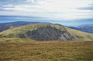
Lochcraig Head is a hill in the Moffat Hills range, part of the Southern Uplands of Scotland. The second highest in the range, its southern slopes drop dramatically into Loch Skeen, the highest loch in the Southern Uplands, from which the Grey Mare's Tail waterfall originates. A common ascent is as a round from the car park to the south, taking in White Coomb.

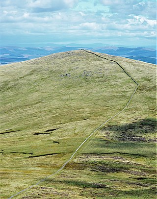
Molls Cleuch Dod is a hill in the Moffat Hills range, part of the Southern Uplands of Scotland. A broad, grassy outlier of the surrounding hills, it is commonly ascended in rounds beginning from the Megget Stane and Talla Linnfoots or as a detour from the Grey Mare's Tail.

Hart Fell is a hill in the Moffat Hills range, part of the Southern Uplands of Scotland. It lies north of the town of Moffat on the border with the Scottish Borders and Dumfries and Galloway.
The Manor Hills, also known as the Tweedsmuir Hills, are a range of hills south of Peebles in the Scottish Borders, one of the ranges which collectively form the Southern Uplands. They are separated from the Moffat Hills by the Talla Reservoir, Megget Reservoir and St. Mary's Loch, the Moorfoot Hills by the A72 and the Culter Hills in South Lanarkshire by the A701. The western portion of the hills are designated as the 'Tweedsmuir Hills' Site of Special Scientific Interest and the 'Upper Tweeddale' National Scenic Area, with the major tributary rivers designated as Special Areas of Conservation.
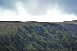
Swatte Fell is a hill in the Moffat Hills range, part of the Southern Uplands of Scotland. It lies north of the town of Moffat in Dumfries and Galloway, south of its parent peak, Hart Fell. It is gently sloping on three sides of the hill, however the east ridge is steep and craggy and features a deep corrie known as Blackhope, from which a popular rock climb, the Coomb Craig ridge, originates, finishing near the summit, and was featured on the OS Explorer 330 map front cover. The normal route is from the southern ridge and can be extended to include a full loop of Blackhope, finishing on Saddle Yoke, known as the Hart Fell Horseshoe.

Black Law is a hill in the Manor Hills range, part of the Southern Uplands of Scotland. One of the more remote Donalds, it does not easily combine into a round with other hills in the area and requires traversing rough terrain to reach the top. Common ascents are as part of an extended Dun Rig Horseshoe to the north-east, from the south at the Megget Reservoir or, most easily, from the Manor Valley itself.
Cairnsgarroch is a hill in the Rhinns of Kells, a sub-range of the Galloway Hills range, part of the Southern Uplands of Scotland. Really one of approximately six satellites of the main ridge, it is usually climbed as a detour. Ascents starting from Garryhorn or Forrest Estate near Carsphairn are the most common, often as part of a complete traverse of the ridge.

Whitehope Heights is a hill in the Moffat Hills range, part of the Southern Uplands of Scotland. The lowest Donald hill in the range, it is separated from Hart Fell by a steep grassy cleuch known as The Gyle. Like its neighbour, the Dumfries and Galloway-Scottish Borders border runs along its summit. The southern slopes of the hill are part of the Corehead hill farm, an area owned by the Borders Forest Trust for the purposes of habitat regeneration; as a result, a large deer fence lines the boundary. East of the Devil's Beef Tub and Annandale Way, it is most frequently climbed from this direction, but ascents from Hart Fell are also common.
The Dungeon Hills are a range of hills in the Galloway Hills range, part of the Southern Uplands of Scotland. The central of three parallel ridges, they are neighboured by the Range of the Awful Hand to the west and the Rhinns of Kells to the east. The range is also perpendicular to the Minnigaff Hills range, immediately south. In total, these four ranges are part of the Galloway Forest Park.

The Rhinns of Kells are a range of hills in the Galloway Hills range, part of the Southern Uplands of Scotland. The most easterly of three parallel ridges, they are neighboured to the west by the Range of the Awful Hand and the Dungeon Hills. The eastern portion of the Minnigaff Hills range lies immediately southwest of the range. In total, these four ranges are part of the Galloway Forest Park. The ridge is located entirely within Dumfries and Galloway, with the base of the western flanks being a northwestern boundary of the county.

The Culter Hills, Coulter Fells or variations thereof, are a range of hills, part of the Southern Uplands of Scotland. They are neighboured to the east by the Manor Hills and are split roughly in half by the border between South Lanarkshire and the Scottish Borders.

The Ettrick Hills are a range of hills, part of the Southern Uplands of Scotland. They are neighboured to the northwest by the Moffat Hills and are located mainly within the Scottish Borders, however the Dumfries and Galloway border covers the south and southwesterly flanks.
