The National Mall is a landscaped park near the downtown area of Washington, D.C., the capital city of the United States. It contains and borders a number of museums of the Smithsonian Institution, art galleries, cultural institutions, and various memorials, sculptures, and statues. It is administered by the National Park Service (NPS) of the United States Department of the Interior as part of the National Mall and Memorial Parks unit of the National Park System. The park receives approximately 24 million visitors each year. Designed by Pierre L'Enfant, the "Grand Avenue" or Mall was to be a democratic and egalitarian space—unlike palace gardens, such as those at Versailles in France, that were paid for by the people but reserved for the use of a privileged few.

The World War II Memorial is a national memorial in the United States dedicated to Americans who served in the armed forces and as civilians during World War II. It is located on the National Mall in Washington, D.C.

Smithsonian station is a Washington Metro station at the National Mall in Washington, D.C., United States. The side platformed station was opened on July 1, 1977, and is operated by the Washington Metropolitan Area Transit Authority (WMATA). It is a stop on the Blue, Orange and Silver Lines. The station's south entrance is at the southwest corner of Independence Avenue and 12th Street, Southwest, the street elevator is at the northwest corner of the same intersection, and the north entrance is on the south side of the Mall near Jefferson Drive, Southwest.

Southwest is the southwestern quadrant of Washington, D.C., the capital of the United States, and is located south of the National Mall and west of South Capitol Street. It is the smallest quadrant of the city, and contains a small number of named neighborhoods and districts, including Bellevue, Southwest Federal Center, the Southwest Waterfront, Buzzard Point, and the military installation known as Joint Base Anacostia–Bolling.

L'Enfant Plaza is a complex of four commercial buildings grouped around a large plaza in the Southwest section of Washington, D.C., United States. Immediately below the plaza and the buildings is La Promenade shopping mall.

Constitution Avenue is a major east–west street in the northwest and northeast quadrants of the city of Washington, D.C., in the United States. It was originally known as B Street, and its western section was greatly lengthened and widened between 1925 and 1933. It received its current name on February 26, 1931, though it was almost named Jefferson Avenue in honor of Thomas Jefferson.

Independence Avenue is a major east-west street in the southwest and southeast quadrants of the city of Washington, D.C., in the United States, running just south of the United States Capitol. Originally named South B Street, Independence Avenue SW was constructed between 1791 and 1823. Independence Avenue SE was constructed in pieces as residential development occurred east of the United States Capitol and east of the Anacostia River. Independence Avenue SW received its current name after Congress renamed the street in legislation approved on April 13, 1934. Independence Avenue SW originally had its western terminus at 14th Street SW, but was extended west to Ohio Drive SW between 1941 and 1942. The government of the District of Columbia renamed the portion of the road in the southeast quadrant of the city in 1950.
The National Capital Parks was a unit of the National Park System of the United States, now divided into multiple administrative units. It encompasses a variety of federally owned properties in and around the District of Columbia including memorials, monuments, parks, interiors of traffic circles and squares, triangles formed by irregular intersections, and other open spaces.

East Potomac Park is a park located on a man-made island in the Potomac River in Washington, D.C., United States. The island is between the Washington Channel and the Potomac River, and on it the park lies southeast of the Jefferson Memorial and the 14th Street Bridge. Amenities in East Potomac Park include the East Potomac Park Golf Course, a miniature golf course, a public swimming pool, tennis courts, and several athletic fields. The park is a popular spot for fishing, and cyclists, walkers, inline skaters, and runners heavily use the park's roads and paths. A portion of Ohio Drive SW runs along the perimeter of the park.
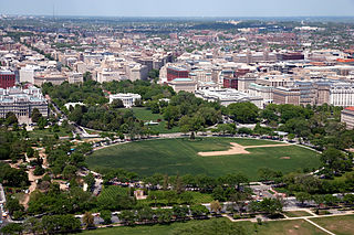
The Ellipse, sometimes referred to as President's Park South, is a 52-acre (21 ha) park south of the White House fence and north of Constitution Avenue and the National Mall in Washington, D.C., US. The Ellipse is also the name of the five-furlong (1.0 km) circumference street within the park. The entire park, which features monuments, is open to the public and is part of President's Park. The Ellipse is the location for many annual events.

The Dwight D. Eisenhower Memorial is a United States presidential memorial in Washington, D.C. honoring Dwight David Eisenhower, the Supreme Commander of the Allied Forces in Europe during World War II and the 34th President of the United States.
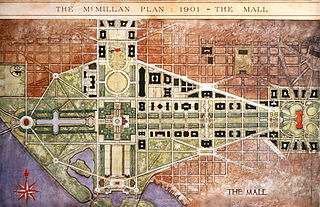
The McMillan Plan is a comprehensive planning document for the development of the monumental core and the park system of Washington, D.C., the capital of the United States. It was written in 1902 by the Senate Park Commission. The commission is popularly known as the McMillan Commission after its chairman, Senator James McMillan of Michigan.

Southwest Federal Center is a business district in Southwest Washington, D.C., nearly entirely occupied by offices for various branches of the U.S. Government, including many of the museums of the Smithsonian Institution.

The U.S. Commission of Fine Arts (CFA) is an independent agency of the federal government of the United States, and was established in 1910. The CFA has review authority over the "design and aesthetics" of all construction within Washington, D.C. In accordance with the Old Georgetown Act, the CFA appoints the Old Georgetown Board. The Old Georgetown Board has design review authority over all semipublic and private structures within the boundaries of the Georgetown Historic District. The CFA was granted approval authority by the Shipstead-Luce Act over the design and height of public and private buildings which front or abut the grounds of the United States Capitol, the grounds of the White House, Pennsylvania Avenue NW extending from the Capitol to the White House, Lafayette Square, Rock Creek Park, the National Zoological Park, the Rock Creek and Potomac Parkway, Potomac Park, and the National Mall and its constituent parks.

The Bartholdi Fountain is a monumental public fountain, designed by Frédéric Auguste Bartholdi, who later created the Statue of Liberty. The fountain was originally made for the 1876 Centennial Exposition in Philadelphia, Pennsylvania, and is now located at the corner of Independence Avenue and First Street, SW, in the United States Botanic Garden, on the grounds of the United States Capitol, in Washington D.C.

The James V. Forrestal Building is a low-rise Brutalist office building in Washington, D.C. Originally known as Federal Office Building 5, and nicknamed the Little Pentagon, the Forrestal Building was constructed between 1965 and 1969 to accommodate United States armed forces personnel. It is named after James Forrestal, the first United States Secretary of Defense. It became the headquarters of the United States Department of Energy after that agency's creation in 1977.

The Baltimore and Potomac Railroad Station, also known as Pennsylvania Railroad Station, was a railroad station that was owned by the Pennsylvania Railroad and operated by the Baltimore and Potomac Railroad in Washington, D.C., from July 2, 1872 until its closure in 1907. It was located at the southern corner of 6th street NW and B Street NW, now the site of the West Building of the National Gallery of Art. It was in this train station that United States President James A. Garfield was shot by assassin Charles J. Guiteau on July 2, 1881.

Isaac Newton was an agriculturalist who became the first United States commissioner of agriculture.

The Armory Square Hospital formally known as the District Armory or Armory of the District of Columbia was a military hospital for the Union Army located on the National Mall in Washington, D.C., which operated from 1862 to 1865. It stood at the intersection of 6th Street SW and B Street SW between the Smithsonian Castle and the Capitol. The 12 wards extended across the Mall, all the way to the Canal. Today, the National Air and Space Museum stands in its place.

Parts of F Street and 7th Street, N.W. and nearby blocks have historically been the heart of the Washington, D.C. Downtown shopping district. In the first half of the 20th century there were numerous upscale large department stores along and near F Street, while 7th Street housed more economical emporia and large retail furniture stores. The F street corridor stretches west from Downtown's Penn Quarter and Gallery Place towards 15th Street, while the 7th Street corridor includes the neighborhoods of Penn Quarter, Chinatown and Mount Vernon Square, and extends up to the border of Shaw.