
Cambridge is a city in Middlesex County, Massachusetts, United States. It is a suburb in the Greater Boston metropolitan area, located directly across the Charles River from Boston. The city's population as of the 2020 U.S. census was 118,403, making it the most populous city in the county, the fourth-largest in Massachusetts behind Boston, Worcester, and Springfield, and ninth-most populous in New England. The city was named in honor of the University of Cambridge in Cambridge, England, which was an important center of the Puritan theology that was embraced by the town's founders.
Kendall Square is a neighborhood in Cambridge, Massachusetts, United States. The square itself is at the intersection of Main Street and Broadway. It also refers to the broad business district east of Portland Street, northwest of the Charles River, north of MIT and south of Binney Street.
Jamaica Plain is a neighborhood of 4.4 square miles (11 km2) in Boston, Massachusetts, United States. Settled by Puritans seeking farmland to the south, it was originally part of Roxbury. The community seceded from Roxbury during the formation of West Roxbury in 1851 and became part of Boston when West Roxbury was annexed in 1874. In the 19th century, Jamaica Plain became one of the first streetcar suburbs in America and home to a significant portion of Boston's Emerald Necklace of parks, designed by Frederick Law Olmsted.
Back Bay is an officially recognized neighborhood of Boston, Massachusetts, built on reclaimed land in the Charles River basin. Construction began in 1859, as the demand for luxury housing exceeded the availability in the city at the time, and the area was fully built by around 1900. It is most famous for its rows of Victorian brownstone homes—considered one of the best preserved examples of 19th-century urban design in the United States—as well as numerous architecturally significant individual buildings, and cultural institutions such as the Boston Public Library, and Boston Architectural College. Initially conceived as a residential-only area, commercial buildings were permitted from around 1890, and Back Bay now features many office buildings, including the John Hancock Tower, Boston's tallest skyscraper. It is also considered a fashionable shopping destination and home to several major hotels.

Dorchester is a neighborhood comprising more than 6 square miles (16 km2) in the City of Boston, Massachusetts, United States. Originally, Dorchester was a separate town, founded by Puritans who emigrated in 1630 from Dorchester, Dorset, England, to the Massachusetts Bay Colony. This dissolved municipality, Boston's largest neighborhood by far, is often divided by city planners in order to create two planning areas roughly equivalent in size and population to other Boston neighborhoods.
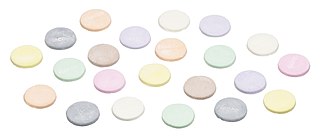
Necco Wafers are a sugar-based candy, sold in rolls of variously-flavored thin disks. First produced in 1847, they became the namesake and core product of the now-defunct New England Confectionery Company (Necco), which operated near Boston, Massachusetts. It is the oldest American candy brand still in production. Production of the candy was suspended in July 2018 when Necco went into bankruptcy, but returned in May 2020 after purchase of the brand and production equipment by the Spangler Candy Company.

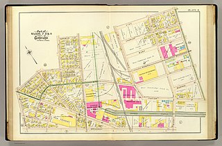
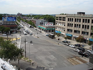
Central Square is an area in Cambridge, Massachusetts centered on the junction of Massachusetts Avenue, Prospect Street and Western Avenue. Lafayette Square, formed by the junction of Massachusetts Avenue, Columbia Street, Sidney Street and Main Street, is also considered a part of the Central Square area. Harvard Square is to the northwest along Massachusetts Avenue, Inman Square is to the north along Prospect Street and Kendall Square is to the east along Main Street. The section of Central Square along Massachusetts Avenue between Clinton Street and Main Street is designated the Central Square Historic District, and was added to the National Register of Historic Places in 1990.
Allston is an officially recognized neighborhood in Boston, Massachusetts, United States. It was named after the American painter and poet Washington Allston. It comprises the land covered by the zip code 02134. For the most part, Allston is administered collectively with the adjacent neighborhood of Brighton. The two are often referred to together as Allston–Brighton. Boston Police Department District D-14 covers the Allston-Brighton area and a Boston Fire Department Allston station is located in Union Square which houses Engine 41 and Ladder 14. Engine 41 is nicknamed "The Bull" to commemorate the historic stockyards of Allston.
The Grand Junction Railroad is an 8.55-mile (13.76 km) long railroad in the Boston, Massachusetts, area, connecting the railroads heading west and north from Boston. The line is notable for its railroad bridge over the Charles River that passes under the Boston University Bridge between Boston and Cambridge, Massachusetts.

Cambridgeport is one of the neighborhoods of Cambridge, Massachusetts. It is bounded by Massachusetts Avenue, the Charles River, the Grand Junction Railroad, and River Street. The neighborhood contains predominantly residential homes, many of the triple decker style common in New England. Central Square, at the northernmost part of Cambridgeport, is an active commercial district and transportation hub, and University Park is a collection of renovated or recently constructed office and apartment buildings. The neighborhood also includes Fort Washington Park, several MIT buildings, and Magazine Beach.

Necco was an American manufacturer of candy created in 1901 as the New England Confectionery Company through the merger of several small confectionery companies located in the Greater Boston area, with ancestral companies dating back to the 1840s.

Squirrel Nut Caramels and Squirrel Nut Zippers were chewy caramel candy mixed with peanuts.
Michael Robert Van Valkenburgh is an American landscape architect and educator. He has worked on a wide variety of projects – including public parks, college campuses, sculpture gardens, corporate landscapes, private gardens, and urban master plans – in the U.S., Canada, Europe and Asia. He has taught at Harvard's Graduate School of Design Since 1982 and served as chair of its Landscape Architecture Department from 1991 to 1996.

Forest City Realty Trust, Inc., formerly Forest City Enterprises, was a real estate investment trust that invested in office buildings, shopping centers and apartments in Boston, Chicago, Dallas, Denver, Los Angeles, Philadelphia, and the greater metropolitan areas of New York City, San Francisco and Washington, D.C. The company was organized in Maryland with its headquarters in Cleveland, Ohio. As of December 31, 2017, the company owned 29 office buildings, 29 shopping centers, and 78 apartment complexes. On December 7, 2018, the company was acquired by Brookfield Asset Management.

Mission Hill is a 3⁄4 square mile, primarily residential neighborhood of Boston, bordered by Roxbury, Jamaica Plain and Fenway-Kenmore and the town of Brookline. The neighborhood has two main streets, namely Tremont Street and Huntington Avenue. It is served by several stations on the MBTA's Green Line E branch, as well as Roxbury Crossing station on the Orange Line.
The Port, formerly Area 4, is a neighborhood of Cambridge, Massachusetts, roughly between Central Square, Inman Square, and MIT. It is bounded on the south by Massachusetts Avenue, on the west by Prospect Street, on the north by Hampshire Street, and on the east by the Grand Junction Railroad tracks. Area 4 is a densely populated residential neighborhood with about 7,000 residents.

The Massachusetts Institute of Technology occupies a 168-acre (68 ha) tract in Cambridge, Massachusetts, United States. The campus spans approximately one mile (1.6 km) of the north side of the Charles River basin directly opposite the Back Bay neighborhood of Boston, Massachusetts.

Columbia Point, in the Dorchester neighborhood of Boston, Massachusetts, sits on a peninsula jutting out from the mainland of eastern Dorchester into the bay. Old Harbor Park is on the north side, adjacent to Old Harbor, part of Dorchester Bay. The peninsula is primarily occupied by Harbor Point, the University of Massachusetts Boston, the John F. Kennedy Presidential Library and Museum, the Edward M. Kennedy Institute for the United States Senate, and a complex at the former Bayside Expo Center, Boston College High School, and the Massachusetts Archives. The Boston Harborwalk follows the entire coastline.

The New England Confectionery Company Factory, also known as the NECCO Candy Factory, is an historic factory complex at 250 Massachusetts Avenue in Cambridge, Massachusetts. The property is now owned by DFS Advisors, and is under long-term lease to Novartis. The complex, which includes the factory building, a power plant, and a modern (2003) parking garage, occupies most of an entire city block bounded by Massachusetts Avenue, Cross Street, Albany Street, and Lansdowne Street. The Moderne-style building was constructed of reinforced concrete, faced predominantly with beige brick and trimmed with limestone. On some facades smooth concrete predominates as the finish surface. The building had a water tower that was painted to resemble a roll of Necco Wafers; during the alterations of the property for use by Novartis, the water tower was retained, and is now painted with a DNA pattern in pastel colors. The building was listed on the National Register of Historic Places in 2005.

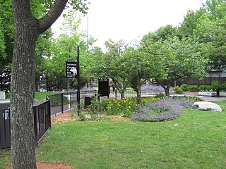
Magazine Beach is a riverside park in Cambridge, Massachusetts, United States. It is located on the left bank of the Charles River, across Memorial Drive from Cambridgeport. The other side of the river has Agganis Arena and other Boston University facilities.

