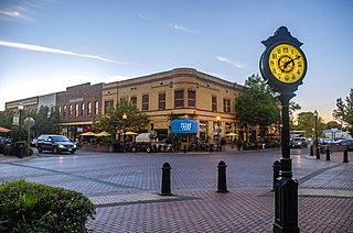
Winters is a city in rural Yolo County, and the western Sacramento Valley, in northern California.

The Valencia orange is a sweet orange cultivar named after the famed oranges in València, Spain. It was first hybridized by pioneer American agronomist and land developer William Wolfskill in the mid-19th century on his farm in Santa Ana, southern California, United States, North America.

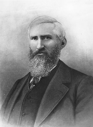
William Wolfskill (1798–1866) was an American-Mexican pioneer, cowboy, and agronomist in Los Angeles, California beginning in the 1830s. He had earned money for land in a decade as a fur trapper near Santa Fe, New Mexico, where he had become a Mexican citizen. This enabled him to own land in California.

Rancho San Francisco was a land grant in present-day northwestern Los Angeles County and eastern Ventura County, California. It was a grant of 48,612 acres (19,673 ha) by Governor Juan B. Alvarado to Antonio del Valle, a Mexican army officer, in recognition for his service to Alta California. It is not related to the city of San Francisco.

The Suisun Valley AVA is an American Viticultural Area in Solano County, California, located just east of the Napa Valley wine region in the Coast Range. It was established as a wine appellation on 27 December 1982, making it among the first AVAs of California, Napa Valley being the first.
Rancho Santa Anita was a 13,319-acre (53.90 km2) land grant in present-day Los Angeles County, California given to naturalized Scottish immigrant Hugo Reid and his Kizh people wife. Reid built an adobe residence there in 1839, and the land grant was formally recognized by Governor Pio Pico in 1845. The land grant covered all or portions of the present day cities of Arcadia, Monrovia, Sierra Madre, Pasadena and San Marino. A small portion of the rancho has been preserved as the Los Angeles County Arboretum and Botanic Garden.
The Alviso Adobe Community Park is a 7-acre (2.8 ha) park in the city of Pleasanton, California, United States. It is built around an adobe house constructed in 1854 by Francisco Alviso on the Rancho Santa Rita Mexican Land Grant. The Alviso Adobe is a rare surviving example of an early American adobe that was continuously in use until 1969. The building is registered as California Historical Landmark #510 in 1954, but most of the historical marker was later found to be erroneous.
The Empire City Historic Landmark is a California Historic Landmark in honor of the pioneer John C. Marvin who from 1850, settled on the south bank of the Tuolumne River and called the town "Empire City". Empire City was the head of navigation for small steamboats that could ascend the Tuolumne River carrying passengers and supplies. It was the shipping point for the large grain crops grown in the area. At its height, the town had three stores, a three-story hotel, two boarding houses, a blacksmith shop, a church, and a school house. Empire City was voted as the county seat of Stanislaus County from October 1854 to December 1855. The town was destroyed by flood waters during the Great Flood of 1862. A new railroad town was built 40 years later 1 mile north of the old town site, taking the name Empire.
Rancho Rio de los Putos, was a 17,755-acre (71.85 km2) Mexican land grant in the western Sacramento Valley, within present-day Solano County and Yolo County, California.
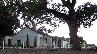
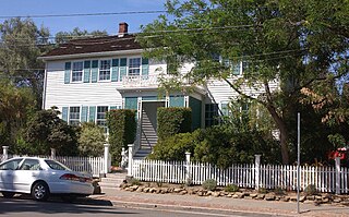
John Reid Wolfskill was a California pioneer who helped establish development of California's agricultural industry in the Sacramento Valley in the 19th century. In 1842, Wolfskill was the first settler to plant vineyards and fruit trees there. Born in the Bluegrass region of Kentucky, he migrated to join his brother William in California, where they bought land near Sacramento. Wolfskill became a pioneer of Solano County: "he was the first English speaking man to settle in the area around what is now Winters, California".

Savannah Memorial Park Cemetery also known as El Monte Memorial Park and the Savannah Pioneer Cemetery is the oldest American non-sectarian cemetery in Southern California. The park is located in Rosemead, California, part of the park is in the neighboring city of El Monte. The park has been in continuous operation since its founding in 1850. Some of the burials may date back into the 1840s before Savannah Memorial Park became a Memorial Park. Savannah Memorial Park was designated a California Historical Landmark on March 6, 2012.

The Old Santa Monica Forestry Station is the nation's first experimental forestry station, built in 1887. The Old Santa Monica Forestry Station was designated a California Historic Landmark (No.840) on March 20, 1970. Old Santa Monica Forestry Station is located at Rustic Canyon in Los Angeles in the Santa Monica Mountains of Southern California in Los Angeles County. The site is south of what is now called Santa Monica Mountains National Recreation Area. In 1971 the state placed a marker near the entrance of the Rustic Canyon Recreation Center at the NW corner of Latimer and Hilltree Roads, at 601 Latimer Road, Los Angeles, CA 90402. This location is in what is now called Pacific Palisades. The hills and canyons around the Santa Monica Canyon were a land boom in the late 1880s.

The Corona Founders Monument is a monument built in 1936 to the founding fathers of the City of Corona in the Riverside County, California. The monument was designated a California Historic Landmark (No.738) on June 6, 1960. The monument is in the Corona City Park in the 100 block of 6th Street of Corona, California. The founding fathers at first called the city South Riverside after the company they started the South Riverside Land and Water Company.
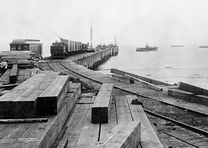
The place of McFadden Wharf was designated a California Historic Landmark (No.794) on July 3, 1964.

The Gates of Anaheim are a series of gates in California that mark the historic entrance to Anaheim, California. Four city gates were built: North, East, South, and West. They were designated a California Historic Landmark (No.122) on March 29, 1933.

Casa de Carrillo House in San Diego, California in San Diego County, is a California Historical Landmark No. 74 listed on December 6, 1932. The Casa de Carrillo House is the oldest residence in San Diego. The Casa de Carrillo House was built by Presidio of San Diego Comandante Francisco María Ruiz (1754–1839). Ruiz was the leader of the Presidio from 1809 to 1827. The Casa de Carrillo house was built next to his pear orchard planted in 1808. The Adobe house was used by his relative and soldier, Joaquín Carrillo, and his family. Joaquín Carrillo, daughter Josefa Carrillo, ran away and sailed from the home and eloped to Chile with Henry Delano Fitch in April 1829. Francisco Ruiz died in 1839, when Joaquín Carrillo died, his son Ramon Carrillo sold the house and land to Lorenzo Soto. The house and land was sold a few times, it was poor condiction when sold in 1932 to George Marston and associates. George Marston and associates restored the house. After the restoration George Marston and associates donated the house and land to the City of San Diego. The City of San Diego turned the house and land into the Presidio Hills Golf Course.
Sebastiani Vineyard and Winery also called the San Francisco Solano de Sonoma Mission Vineyard was founded in 1825 in Sonoma, California in Sonoma County, California. The Sebastiani Vineyard and Winery is a California Historical Landmark No. 739 listed on June 6, 1960. Sebastiani Vineyard and Winery was founded by the Franciscan Fathers at the Mission San Francisco Solano. The wine produced was used for Holy communion in worship church services and Holy mass. The San Francisco Solano de Sonoma Mission Vineyard was the first vineyard in Sonoma Valley. All the California Missions lost land and building in the Mexican secularization act of 1833. First Mexican Republic sold the San Francisco Solano de Sonoma Mission Vineyard to Samuele Sebastiani in 1902. Sebastiani was a young immigrant from Italy who ran the Sebastiani Vineyard and Winery with his wife Elvira. The Sebastiani Vineyard and Winery continues to be a Sebastiani family runs vineyard and winery at 394 4th Street in Sonoma.
Fischer-Hanlon House is historical house built in 1858 in Benicia, California in Solano County, California. The Fischer-Hanlon House is a California Historical Landmark No. 880 listed on March 14, 1975. The Fischer-Hanlon House was built by Joseph Fisher in 1849. Fisher was Swiss immigrant who came to Benicia and purchased a plot of land on July 1, 1858. He then purchased a nearby old hotel and had it moved to his lot. The California Gold Rush home is built in an East Coast Federalist architecture styling. For a living Fisher was in a butcher partnership in Benicia. The wooden house has fourteen rooms. The house had damage in 1856 fire. After Joseph and Catherine Fischer moved in they repaired and remodeled home. The Fischer house was passed down to later generations, then was donated to the State of California in 1969. The donation was done by Fischer's granddaughters, Raphaelita and Catherine Hanlon, in memory to sister Marie Rose. The Fischer-Hanlon House is restored and is furnished in 1880s decor. The outside as Victorian Garden.

Saint Paul's Episcopal Church of Benicia is historical church Building built in 1859 in Benicia, California in Solano County, California. The Saint Paul's Episcopal Church is a California Historical Landmark No. 862 listed on July 20, 1973. Saint Paul's Episcopal Church was designed Lt. Julian McAllister and built by shipwrights of the Pacific Mail Steamship Company. Saint Paul's Episcopal Church is built in the early California Gothic ecclesiastical architecture. The church as dedicated 0n February 12, 1860, 163 years ago, by the church's first pastor Rev. William Ingraham and is still open. The church was founded on September 24, 1854 169 years ago, by Major F. D. Townsend, with the US Army in the Benicia Sate Capital Building.

Peña Adobe Park is a 8 acre park in Vacaville, California in Solano Count. The Peña Adobe Regional Park is at 4699 Pena Adobe Road, Vacaville. Peña Adobe Regional Park has a Vaca-Peña Adobe Visitor Center and has 40 miles of trails. Peña Adobe Park is in the 306-acre Lagoon Valley Park. The parks were part of Juan Felipe Peña land grant Rancho Los Putos. The park is both a recreational park and place with historical sites.


