Upper Assam division

Last updated
Upper Assam
A bird's eye view of Dibrugarh city.jpg
Dibrugarh is the largest city in Upper Assam division
Divisions of Assam.svg
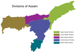
The five divisions of Assam
Country India
State Assam
Largest city Dibrugarh
Headquarters Jorhat
Population
  Total7.5 million
Time zone UTC +05:30 (IST)

Upper Assam is an administrative division of the state of Assam comprising the undivided Lakhimpur and Sivasagar (previously, Sibsagar) districts, of the upper reaches of the Brahmaputra valley. The other divisions are: Lower Assam, North Assam and Hills and Barak Valley. The division is under the jurisdiction of a Commissioner, stationed at Jorhat.

Contents

Consisting of 7 districts initially, the Upper – Assam division now contains 10 districts, that includes Biswanath, Jorhat, Dibrugarh, Dhemaji, Golaghat, Charaideo, Lakhimpur, Majuli, Sivasagar, and Tinsukia. While Charaideo and Majuli are the newest districts that were raised to district status in 2016, [1] [2] Golaghat and Tinsukia are the biggest districts in terms square kilometre area in the region, raised to the district status in the years of 1987 and 1989 respectively. [3] [4]

Dibrugarh, 1 Golaghat 2 and Jorhat 3 are also the oldest recognised and constantly inhabited urban centres (municipal areas) in the region based on the earliest years of formation of the civic bodies, constituted before the Indian independence of 1947. [5]

An extended list of Upper – Assam region also includes the districts of Sonitpur, Karbi Anglong & Nagaon. The region is the most productive part of the state of Assam, which is rich in natural resources like coal, oil and natural gas as well as tea plantations.

History

13th century

Most of Upper Assam under the control of Mong Mao ruler Si Kefa (yellow) in 1360 CE Mong Mao-the detail map.svg
Most of Upper Assam under the control of Möng Mao ruler Si Kefa (yellow) in 1360 CE

Medieval period

Chutia Kingdom

The medieval Chutia Kingdom was on the bank of the river Brahmaputra. It was a powerful kingdom which had ruled in northeastern Assam and some areas of present-day Arunachal Pradesh, with the capital at Sadiya. The kingdom controlled almost the entire region of present Assam districts of Lakhimpur, Dhemaji, Tinsukia and Dibrugarh as well as parts of Sonitpur, Golaghat, Jorhat and Sibsagar districts. In Arunachal Pradesh, it covered the districts bordering Assam.

Ahom Kingdom

The Ahom Kingdom was a kingdom in the Brahmaputra valley in Assam that maintained its sovereignty for nearly 600 years and successfully resisted Mughal expansion in North-East India. Established by Sukaphaa, a Tai prince from Mong Mao, it began as a Mong in the upper reaches of the Brahmaputra river. It expanded suddenly under Suhungmung in the 16th century after annexing the Chutia kingdom and parts of Kachari kingdom and therefore became multi-ethnic in character. The kingdom became weaker with the rise of the Moamoria rebellion, and subsequently fell to a succession of Burmese invasions. With the defeat of the Burmese after the First Anglo-Burmese War and the Treaty of Yandabo in 1826, control of the kingdom passed into British (East India Company) hands.

Demographics

The Upper Assam division, comprising 24 percent of Assam's population at 7.56 million, predominantly adheres to Hinduism, with Islam being the second most practiced religion, embraced by over 80 percent of its people. More than 60 percent of the people speak Assamese with a sizeable Bengali and Hindi minority. The major communities of Upper assam are Ahom, Chutia, Tea tribes, Mishing, Sonowal Kacharis, Moran, Matak, Deori, Thengal Kacharis and indigenous Assamese Muslim communities like Gorias Morias .

Notes

Notes

  1. "Preparations afoot for inauguration of Charaideo district at Sonari, The Eastern Today". ET Correspondent. 10 February 2016.
  2. "Assam: Majuli becomes 1st river island district of India". Hindustan Times . Guwahati. 27 June 2016. Retrieved 28 June 2016.
  3. Law, Gwillim (2011-09-25). "Districts of India". Statoids. Retrieved 2011-10-11.
  4. "Various Districts in Assam".
  5. Sharma, Anil Kumar (1 January 2007). "Quit India Movement In Assam". Mittal Publications. Retrieved 5 August 2016 via Google Books.
  6. "Dibrugarh Municipal Board".
  7. "AGP lists civic poll candidates (Golaghat Municipal Board)". Archived from the original on June 30, 2015. Retrieved 5 August 2016.
  8. "Jorhat Municipal Board(JBM), Jorhat, Assam". Archived from the original on 2016-03-27. Retrieved 2016-08-05.

Related Research Articles

<span class="mw-page-title-main">Dibrugarh district</span> District of Assam in India

Dibrugarh district (Pron:ˌdɪbru:ˈgor:) is a district in the state of Assam in India. The district headquarters are located within the city of Dibrugarh.

<span class="mw-page-title-main">Lakhimpur district</span> District of Assam in India

Lakhimpur district is an administrative district in the state of Assam in India. The district headquarter is located at North Lakhimpur. The district is bounded on the North by Siang and Papumpare districts of Arunachal Pradesh and on the East by Dhemaji District and Subansiri River. Majuli District stands on the Southern side and Biswanath District is on the West.

<span class="mw-page-title-main">Sivasagar</span> Municipality in Assam, India

Sivasagar is a town and headquarter of the Sivasagar district, Assam. Sivasagar is situated about 360 kilometers (224 mi) northeast of Guwahati. It is well known for its Ahom palaces and monuments. Sivasagar is an important centre for tea and oil industries today.

<span class="mw-page-title-main">Jorhat district</span> District of Assam in India

Jorhat is an administrative district of the Indian state of Assam situated in the central part of the Brahmaputra Valley. The district is bounded by Majuli on north, Nagaland state on the south, Sivasagar on the east and Golaghat on the west. On the north of the district, the river Brahmaputra forms the largest riverine island of the world. The administrative seat is at Jorhat city.

<span class="mw-page-title-main">Sivasagar district</span> District in Assam, India

Sivasagar district, formerly known as Sibsagar, is one of the 34 districts of Assam state in Northeast India. Sivasagar city is the administrative headquarters of this district. This historic place is also known for its rich biodiversity. The districts covers an area of 2668 square kilometers. The district comprises two sub-divisions – Sivasagar and Nazira. The district of Sivasagar lies between 26.45°N and 27.15°N latitudes and 94.25°E and 95.25°E longitudes. The district is bounded by the Brahmaputra River to the north, Nagaland to the south, the Charaideo district to the east and the Jhanji River to the west. The Sivasagar district has acquired its distinct identity due to the co-existence of different races, tribes, languages and cultures.

<span class="mw-page-title-main">Dhemaji district</span> District of Assam in India

Dhemaji district is an administrative district in the state of Assam in India. The district headquarters are located in Dhemaji and commercial headquarters are located in Silapathar. Dhemaji covers an area of 3,237 km2 and has a population of 686,133. The predominant religion is Hinduism, with Hindus comprising approximately 95.47% of the population.

Moran Town is a census town in Dibrugarh district in the Indian state of Assam. Moran is an important industrial town in India. It is a major oil field and a major tea-producing area.

Moranhat is a town and a town area committee in Charaideo district in the Indian state of Assam.The town is divided by N.H 37 into Charaideo and Dibrugarh district.

Mising is a Tani language spoken by the Mising people. There are 629,954 speakers, who inhabit mostly in the Dhemaji district, Lakhimpur, Sonitpur, Dibrugarh, Sibsagar, Jorhat, Majuli, Golaghat, Tinsukia districts of Assam and also some parts of Arunachal Pradesh. The primary literary body of Mising is known as 'Mising Agom Kébang '.

<span class="mw-page-title-main">Administrative divisions of Assam</span> Regional divisions in Assam

The state of Assam in India has five regional divisions, each comprising a number of districts. The person responsible for the administration of a division is designated as a Divisional Commissioner.

<span class="mw-page-title-main">Tourism in Assam</span> Tourism in Assam, India

Assam is the main and oldest state in the North-East Region of India and as the gateway to the rest of the Seven Sister States. The land of red river and blue hills, Assam comprises three main geographical areas: the Brahmaputra Valley which stretching along the length of the Brahmaputra river, the Barak Valley extending like a tail, and the intervening Karbi Plateau and North Cachar Hills. Assam shares its border with Meghalaya, Arunachal Pradesh, Nagaland, Manipur, Tripura, Mizoram and West Bengal; and there are National Highways leading to their capital cities. It also shares international borders with Bhutan and Bangladesh and is very close to Myanmar. In ancient times Assam was known as Pragjyotisha or Pragjyotishpura, and Kamarupa.

<span class="mw-page-title-main">Chutia Kingdom</span> Medieval state of India

The Chutia Kingdom was a late medieval state that developed around Sadiya in present Assam and adjoining areas in Arunachal Pradesh. It extended over almost the entire region of present districts of Lakhimpur, Dhemaji, Tinsukia, and some parts of Dibrugarh in Assam, as well as the plains and foothills of Arunachal Pradesh. The kingdom fell around the year 1524 to the Ahom Kingdom after a series of conflicts and the capital area ruled by the Chutia rulers became the administrative domain of the office of Sadia Khowa Gohain of the Ahom kingdom.

The Sonowal Kachari are one of the indigenous peoples of the state of Assam in Northeast India. They are of Tibeto-Burman origin, and are closely associated with the other ethnic groups of Assam, which are commonly referred to as Kachari.

<span class="mw-page-title-main">Tiwa people (India)</span> Ethnic group of north-eastern India

The Tiwa people, are a Tibeto-Burmese ethnic group primarily inhabiting the Northeast Indian states of Assam, Meghalaya, Arunachal Pradesh, Manipur and Nagaland, and some parts of neighbouring Bangladesh and Myanmar.

Assam – 16th largest, 15th most populous and 26th most literate state of the 28 states of the democratic Republic of India. Assam is at 14th position in life expectancy and 8th in female-to-male sex ratio. Assam is the 21st most media exposed states in India. The Economy of Assam is largely agriculture based with 69% of the population engaged in it. Growth rate of Assam's income has not kept pace with that of India's during the Post-British Era; differences increased rapidly since the 1970s. While the Indian economy grew at 6 percent per annum over the period of 1981 to 2000, the same of Assam's grew only by 3.3 percent.

The Brahmaputra floods refers to a catastrophic flood event that occurred in 2012 along the Brahmaputra River and its tributaries, as well as in subsequent years.

The 2018 Assam panchayat election were held in two phases, on 5 and 9 December 2018. The counting of votes started on 12 December and results were declared on 15 December. More than 15.6 million people were eligible to vote and voter turnout was over 78 per cent.

<span class="mw-page-title-main">Moran people</span> Ethnic group found in the northeast Indian states of Assam and Arunachal Pradesh

The Moran are an ethnic group found in the northeast Indian states of Assam and Arunachal Pradesh. They are of Tibeto-Burman origin and belong to the Kachari family. They speak Assamese language, though they used to speak Moran language which was alive until the early 20th century and was closely related to the Dimasa language. They once shared the same allied customs with other Kachari groups, but after their conversion to Vaishnavism, the customs began to diminish, but still, those customs can be seen intermixed with Vaishnavism.

References