Some parts of Lower Assam and North Bengal were under the Kingdom of Bhutan before the 1865 Duar War
Around 1498-1502, Sultan Alauddin Hussain Shah of Gaur conquered parts of Lower Assam during the Bengal-Kamata War.[2][3] The Sultan appointed his son, Shahzada Danyal,[4] as the governor of the newly conquered region; that reached up to Hajo and intended to expand to Central Assam. Danyal governed Kamata for several more years until the Assamese Bhuyans led by Harup Narayan led a campaign against him. In this campaign, the Bhuyans seized and killed Danyal and his officers, thus ending the Sultanate's short rule over the territory some time before 1509.[5][6][7]Musundar Ghazi succeeded Danyal as Bengal's representative in Kamrup.[8][bettersourceneeded] Some parts of Lower assam districts were under rule of the Kingdom of Bhutan until the 19th century.[9]
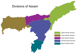
According to the 2011 census, the total number of Assamese speakers in the division were 59,61,583, Bengali speakers were 34,76,953, Boro speakers were 8,70,198 and Hindi speakers were 3,17,958. Although the Bengali speaking population was 30.9% as per the 2011 census language report, Lower Assam Division is home to a large Muslim population of Bengali origin, most of whom now identify as Assamese speakers in the census.[17][18]
Muslims are around 49.5% of the total lower Assam population at the time of the 2011 census.[citation needed]
Phuntsho, Karma (2013). The History of Bhutan. Penguin Books. ISBN9781908323583.
Sarkar, J. N. (1992), "Chapter II The Turko-Afghan Invasions", in Barpujari, H. K. (ed.), The Comprehensive History of Assam, vol.2, Guwahati: Assam Publication Board, pp.35–48
This page is based on this Wikipedia article Text is available under the CC BY-SA 4.0 license; additional terms may apply. Images, videos and audio are available under their respective licenses.