Related Research Articles

Brecknockshire, also known as the County of Brecknock, Breconshire, or the County of Brecon, was one of the thirteen historic counties of Wales. It was created in 1536 under the Laws in Wales Act 1535. From 1889 it was an administrative county with a county council; the administrative county was abolished in 1974. The county was named after the medieval Welsh territory of Brycheiniog, which was anglicised to "Brecknock" and also gave its name to the county town of Brecon. The county was mountainous and primarily rural.

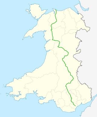
The A470 is a trunk road in Wales. It is the country's longest road at 186 miles (299 km) and links the capital Cardiff on the south coast to Llandudno on the north coast. While previously one had to navigate the narrow roads of Llanidloes and Dolgellau, both these market towns are now bypassed due to extensive road modernisation. The 26 miles (42 km) from Cardiff Bay to Merthyr Tydfil are mainly dual carriageway, but most of the route from north of Merthyr to Llandudno is single carriageway.

Builth Wells is a market town and community in the county of Powys and historic county of Brecknockshire (Breconshire), mid Wales, lying at the confluence of rivers Wye and Irfon, in the Welsh part of the Wye Valley. In 2011 it had a population of 2,568.

Llanelwedd is a village and community near Builth Wells, in Powys, Wales. It lies within the historic boundaries of Radnorshire. Llanelwedd features the Royal Welsh Showground.

Cwmtwrch is a village in the valley of the Afon Twrch, a right-bank tributary to the Swansea Valley, Wales, some 15 miles north of Swansea. It is also the name of an electoral ward to Powys County Council.

New Inn is a village and community directly south east of Pontypool, within the County Borough of Torfaen in Wales, within the historic boundaries of Monmouthshire. It had a population of 5,986 at the 2011 Census.

The Diocese of Swansea and Brecon is a Diocese of the Church in Wales, established in 1923 with Brecon Priory as the cathedral. The area of the diocese had formerly been the Archdeaconry of Brecon within the Diocese of St Davids. The diocese has a border with each of the other five Welsh dioceses, as well as with the English Diocese of Hereford.

Capel-y-ffin is a hamlet near the English-Welsh border, a couple of miles north of Llanthony in Powys, Wales. It lies within the Black Mountains and within the Brecon Beacons National Park. The nearest town is Hay-on-Wye, some 8 miles (13 km) to the northwest.

Fochriw is a village in Caerphilly County Borough, Wales. It was well known for its neighbouring collieries, which employed nearly the entire local population in the early 20th century. It lies within the historic county boundaries of Glamorgan. The village appears as the backdrop on the BBC Wales sitcom High Hopes credits. The village's population was 1,250 in 2011.

The Vale of Ewyas is the steep-sided and secluded valley of the River Honddu, in the Black Mountains of Wales and within the Brecon Beacons National Park. As well as its outstanding beauty, it is known for the ruins of Llanthony Priory, and for several noteworthy churches such as those at Capel-y-ffin and Cwmyoy. It is sometimes referred to as the "Llanthony Valley" as Llanthony is the village situated at the valley centre.

Mynydd Epynt is an upland region of Mid Wales, within the county of Powys. It is bounded on the south by the upper stretch of the Usk Valley, on the north by the Irfon Valley, and on the east by the Wye Valley. Its western boundary is less distinct but lies east of the A483 Llandovery to Llanwrtyd Wells road.

The River Honddu is a river in the county of Powys, mid Wales. Early recorded versions of the name are of the form Hothenei and hodni which are believed to contain the Welsh adjective 'hawdd', meaning 'pleasant' or 'easy', together with a suffix -ni. Later forms such as Honddey and Honthy have undergone metathesis whereby -ddn- became -ndd-.

Merthyr Cynog is a hamlet and a community in the modern county of Powys, Wales, in the historic county of Brecknockshire. The population of the community at the 2021 Census was 245.

Aber Village or Aberclydach is a hamlet within the Brecon Beacons National Park in Powys, Wales. It is centred on the minor road which runs south from Talybont-on-Usk up the Caerfanell valley known as Glyn Collwn across the Brecon Beacons to Pontsticill and Merthyr Tydfil. Aberclydach lies within the community of Talybont-on-Usk about 1.5 km to the south of the village of Talybont and 0.5 km to the north of the dam of Talybont Reservoir.

Penderyn is a rural village in the Cynon Valley, Rhondda Cynon Taf, Wales, located near Hirwaun.

Honddu Isaf is a community in Powys, situated immediately to the north of Brecon on either side of the B4520 road to Builth Wells. It is in the historic county of Brecknockshire.
Castell Madoc is a small rural village in Brecon, Powys. The village lies next to Mynydd Epynt, on Afon Honddu, one of the most important tributaries of the River Usk.

Yscir with Honddu Isaf and Llanddew is the name of an electoral ward in southern Powys, Wales. It covers five local government communities and elects a councillor to Powys County Council.
References
- ↑ Ordnance Survey Explorer map sheet no 188 'Builth Wells/Llanfair-ym-Muallt'
52°03′N3°27′W / 52.050°N 3.450°W