
San Bernardino County, officially the County of San Bernardino and sometimes abbreviated as S.B. County, is a county located in the southern portion of the U.S. state of California, and is located within the Inland Empire area. As of the 2020 U.S. Census, the population was 2,181,654, making it the fifth-most populous county in California and the 14th-most populous in the United States. The county seat is San Bernardino.

San Bernardino is a city in and the county seat of San Bernardino County, California, United States. Located in the Inland Empire region of Southern California, the city had a population of 222,101 in the 2020 census, making it the 18th-largest city in California. San Bernardino is the economic, cultural, and political hub of the San Bernardino Valley and the Inland Empire. The governments of El Salvador, Guatemala, and Mexico have established the metropolitan area's only consulates in the downtown area of the city. Additionally, San Bernardino serves as an anchor city to the 3rd largest metropolitan area in California and the 12th largest metropolitan area in the United States; the San Bernardino-Riverside MSA. Furthermore, the city's University District serves as a college town, as home to California State University, San Bernardino.

Arrowhead Water, also known as Arrowhead Mountain Spring Water, is a brand of drinking water that is sold in the western United States, particularly in Idaho, Nevada, Arizona, Utah, Colorado, New Mexico, Northwestern United States, the Northwest, and in California. It is bottled from 13 springs throughout the Western United States.

Hot Springs National Park is a national park of the United States in central Garland County, Arkansas, adjacent to the city of Hot Springs. Hot Springs Reservation was initially created by an act of the United States Congress on April 20, 1832, to be preserved for future recreation. Established before the concept of a national park existed, it was the first time that land had been set aside by the federal government to preserve its use as an area for recreation. The hot spring water has been popularly believed for centuries to possess medicinal properties, and was a subject of legend among several Native American tribes. Following federal protection in 1832, the city developed into a successful spa town.

Arrowhead Springs is a highly mountainous neighborhood in the 81-square-mile (210 km2) municipality of San Bernardino, California, officially annexed to the city on November 19, 2009. The neighborhood lies below the Arrowhead geological monument, which is California Historical Landmark #977.

The San Bernardino Valley is a valley in Southern California located at the south base of the Transverse Ranges. It is bordered on the north by the eastern San Gabriel Mountains and the San Bernardino Mountains; on the east by the San Jacinto Mountains; on the south by the Temescal Mountains and Santa Ana Mountains; and on the west by the Pomona Valley. Elevation varies from 590 feet (180 m) on valley floors near Chino to 1,380 feet (420 m) near San Bernardino and Redlands. The valley floor is home to over 80% of the more than 4 million people in the Inland Empire region.
San Bernardino, California, was named in 1810.
Inland Center is a regional shopping mall owned and operated by Macerich, located in San Bernardino, California along the southwest border adjacent to Interstate 215 and the city of Colton. The mall is within one mile of three bordering cities on the southern end of San Bernardino. Inland Center is a single-level mall anchored by, JCPenney, Forever 21 and Macy's, plus 110 specialty shops and services.

Bathhouse Row is a collection of bathhouses, associated buildings, and gardens located at Hot Springs National Park in the city of Hot Springs, Arkansas. The bathhouses were included in 1832 when the Federal Government took over four parcels of land to preserve 47 natural hot springs, their mineral waters which lack the sulphur odor of most hot springs, and their area of origin on the lower slopes of Hot Springs Mountain.

Seigler Springs is a set of springs in Lake County, California around which a resort developed in the 19th century. In the 1930s the resort was expanded, and in 1947 an airport opened nearby. The resort declined in the 1960s. Part of it was separated out and became a residential subdivision, while part became a religious retreat. The 2015 Valley Fire caused great damage.

Gilman Hot Springs, also known as San Jacinto Hot Springs or the Relief Springs, is a hot spring system in the Inland Empire area of Southern California. Located near Potrero Creek, the San Jacinto River, and California State Route 79, the springs system consists of "about half a dozen" springs named for the Mexican land grant Rancho San Jacinto Viejo.
Politana or Apolitana was the first Spanish settlement in the San Bernardino Valley of California. It was established as a mission chapel and supply station by the Mission San Gabriel in the a rancheria of the Guachama Indians that lived on the bluff that is now known as Bunker Hill, near Lytle Creek. Besides the Guachama, it was also at various times the home for colonists from New Mexico and Cahuilla people. Its most prominent landmark today is the St. Prophet Elias Greek Orthodox Church on Colton Avenue, just southwest of the Inland Center Mall, in San Bernardino, California.

Seminole Hot Springs is an unincorporated community in Los Angeles County, California, United States. Seminole Hot Springs is located in the Santa Monica Mountains near Cornell, 3.6 miles (5.8 km) south-southeast of Agoura Hills at an elevation of 932 feet (284 m).

Bimini Baths was a geothermal mineral water public bathhouse and plunge in what is now Koreatown, Los Angeles, California, US. It was situated just west of downtown, near Third Street and Vermont Avenue. Bimini Baths contained a natatorium, swimming pools, swimming plunge, Turkish baths, a medical treatment department, and bottling works.

The Urbita Lake Railway was a 1⁄2 mile (0.8 km) long miniature railway with a gauge of 18 in, which operated from approximately 1910 to at least August 1915 at Urbita Hot Springs park in San Bernardino, California.
Jules Berman was a liquor importer, southern California real estate developer and Pre-Columbian art collector known as "Mr Kahlua".

Hot Wells is the site of a cultural historical park in San Antonio, Texas. The park complements Texas' only World Heritage Site—the nearby San Antonio Missions National Historical Park—and the Mission Reach of the San Antonio River Walk. The park is located on the east side of the San Antonio River, directly across South Presa Street from the San Antonio State Hospital, along the tracks of the Southern Pacific Railroad and within sight of Mission San José across the river. Prior to the arrival of the Spanish, the land was originally inhabited by Coahuiltecan peoples.

Radium Sulphur Springs, located on the north side of Melrose Avenue between Larchmont and Gower Street in Los Angeles, California, U.S., was an early-20th-century hot spring that resulted from an unsuccessful attempt to drill 1,500 feet (460 m) for oil. "Discovered" in 1905 and opened as a spa by G. P. Gehring in 1908, the owners claimed that the water was radioactive, germicidal, and blood purifying. The supposed radioactivity of water was advertised as "liquid sunshine" and was part of the larger radium fad of the early 20th century. The spa was located in Colegrove, an electric-railway stop and associated community just south of Hollywood.

Soboba Hot Springs are a historic hot springs and resort in Riverside County, California, United States. The springs issued from the side of a steep ravine "with narrow, precipitous sides, and the rock exposed is largely a crushed gneiss...the thermal character of the springs is due to crushing and slipping of the rocks". The Soboba Hot Springs resort was adjacent to the reservation of the Soboba Band of Luiseño Indians. Soboba means hot water in the Luiseño language.

Paso Robles Hot Springs is a system of geothermal hot springs in the area of Paso Robles in San Luis Obispo County, California. They were developed in the late 19th and early 20th century.


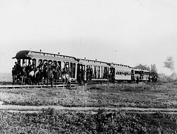 Group photo of passengers on the first train in the city which connected with Urbita Springs (LAPL 00032341, Works Progress Administration Collection)
 Urbita Hot Springs near San Bernardino, California (University of Texas Medical Branch image collections)


