
Satellite images are images of Earth collected by imaging satellites operated by governments and businesses around the world. Satellite imaging companies sell images by licensing them to governments and businesses such as Apple Maps and Google Maps.
Surrey Satellite Technology Ltd, or SSTL, is a company involved in the manufacture and operation of small satellites. A spin-off company of the University of Surrey, it is presently wholly owned by Airbus Defence and Space.

RapidEye AG was a German geospatial information provider focused on assisting in management decision-making through services based on their own Earth-observation imagery. The company operated a five-satellite constellation producing 5-meter resolution imagery that was designed and implemented by MacDonald Dettwiler of Richmond, Canada.

SAR-Lupe is Germany's first reconnaissance satellite system and is used for military purposes. SAR is an abbreviation for synthetic-aperture radar, and "Lupe" is German for magnifying glass. The SAR-Lupe program consists of five identical (770 kg) satellites, developed by the German aeronautics company OHB-System, which are controlled by a ground station responsible for controlling the system and analysing the retrieved data. A large data archive of images will be kept in a former Cold War bunker belonging to the Kommando Strategische Aufklärung of the Bundeswehr. The total price of the satellites was over 250 million Euro.
The Disaster Monitoring Constellation for International Imaging (DMCii) or just Disaster Monitoring Constellation (DMC) consists of a number of remote sensing satellites constructed by Surrey Satellite Technology Ltd (SSTL) and operated for the Algerian, Nigerian, Turkish, British and Chinese governments by DMC International Imaging. The DMC provides emergency Earth imaging for disaster relief under the International Charter for Space and Major Disasters, which the DMC formally joined in November 2005. Other DMC Earth imagery is used for a variety of civil applications by a variety of governments. Spare available imaging capacity is sold under contract.
The RADARSAT Constellation Mission (RCM) is a three-spacecraft fleet of Earth observation satellites operated by the Canadian Space Agency. The RCM's goal is to provide data for climate research and commercial applications including oil exploration, fishing, shipping, etc. With satellites smaller than RADARSAT-2, the RCM will provide new applications—made possible through the constellation approach—as well as continuing to provide C-band radar data to RADARSAT-2 users. One of its most significant improvements is in its operational use of synthetic-aperture radar (SAR) data. The primary goal of RCM is to provide continuous C-band SAR data to RADARSAT-2 users, as SAR imagery at a high temporal resolution is required by several users in the Canadian government. Other improvements include more frequent area coverage of Canada and reduced risk of a service interruption. The RCM will provide the world's most advanced, comprehensive method of maintaining Arctic sovereignty, conducting coastal surveillance, and ensuring maritime security.

Copernicus is the Earth observation component of the European Union Space Programme, managed by the European Commission and implemented in partnership with the EU member states, the European Space Agency (ESA), the European Organisation for the Exploitation of Meteorological Satellites (EUMETSAT), the European Centre for Medium-Range Weather Forecasts (ECMWF), the Joint Research Centre (JRC), the European Environment Agency (EEA), the European Maritime Safety Agency (EMSA), Frontex, SatCen and Mercator Océan.
COSMO-SkyMed is an Earth-observation satellite space-based radar system funded by the Italian Ministry of Research and Ministry of Defence and conducted by the Italian Space Agency (ASI), intended for both military and civilian use. The prime contractor for the spacecraft was Thales Alenia Space. COSMO SkyMed is a constellation of four dual use Intelligence, surveillance, target acquisition, and reconnaissance (ISR) Earth observation satellites with a synthetic-aperture radar (SAR) as main payload, the result of the intuition of Giorgio Perrotta in the early nineties. The synthetic-aperture radar was developed starting in the late nineties with the SAR 2000 program funded by ASI.
Deimos-1 is a Spanish Earth imaging satellite which is operated by Deimos Imaging who commercializes its imagery directly but also has distribution agreements with other entities like Astrium GEO and DMC International Imaging.
UK-DMC 2 is a British Earth imaging satellite which is operated by DMC International Imaging. It was constructed by Surrey Satellite Technology, based on the SSTL-100 satellite bus. It is part of Britain's contribution to the Disaster Monitoring Constellation, which is coordinated by DMC International Imaging. It is the successor to the UK-DMC satellite.
ALSAT-1 is the first Algerian satellite and it is part of a group of satellites collectively known as the Disaster Monitoring Constellation (DMC). The satellite was built by a group of engineers from Surrey Satellite Technology (SSTL) and Algerian Centre National des Techniques Spatiales (CNTS). It was the first DMC satellite to be launched of the five to seven that are planned. The DMC was the first satellite constellation designed for that objective. The launch took place on 28 November 2002 from the Plesetsk Cosmodrome in northern Russia on a Kosmos-3M launcher in -20 degree Celsius weather. It completed its mission after seven years and nine months in August 2010. The satellite was designed to operate for five years.

Planet Labs PBC is a publicly trading American Earth imaging company based in San Francisco, California. Their goal is to image the entirety of the Earth daily to monitor changes and pinpoint trends.
Deimos-2 is a Spanish remote sensing Earth observation satellite built for Elecnor Deimos under an agreement with Satrec Initiative, a satellite manufacturing company in South Korea.
Satellogic Inc. is a company specializing in Earth-observation satellites, founded in 2010 by Emiliano Kargieman and Gerardo Richarte.
PicoDragon is a small satellite that followed the 1U type of CubeSat program built by the Vietnam National Satellite Center (VNSC) which belongs to VAST and operated in space for 3 months.

Capella Space is an American space company with satellite and declassified SAR data solutions for government and commercial use. It offers space-based radar Earth observation satellites equipped with synthetic-aperture radar that can collect imagery through clouds and at night. The company is based in San Francisco, California with offices in Washington, D.C., and Louisville, Colorado. It was founded by Payam Banazadeh, a former engineer at Jet Propulsion Laboratory of NASA, and William Walter Woods.

Satrec Initiative Co., Ltd. or SI is a South Korean satellite manufacturing company headquartered in Daejeon, South Korea The company was founded in 1999 by the engineers who developed the first Korean satellite (KITSAT-1) at KAIST SaTRec. The company designs and builds Earth observation satellites called SpaceEye-series, and it provides various space components, including high resolution electro-optical payloads and star-trackers. SI's first satellite was a Malaysian Earth observation satellite, RazakSAT launched in 2009. SI has two subsidiaries: SI Imaging Services (SIIS) is the exclusive image data provider of KOMPSAT-series, and SI Analytics (SIA) provides AI-native GEOINT solutions for satellite imagery. SI also spun-off SI Detection (SID), which provides radiation monitoring solutions.

PSLV-C42 was the 44th mission of the Indian Polar Satellite Launch Vehicle (PSLV) program and its 12th mission in the Core Alone (CA) configuration. PSLV-C42 successfully carried and deployed 2 Earth observation satellites in Sun-synchronous orbits at an altitude of 588 kilometres (365 mi). It was launched on 16 September 2018 by the Indian Space Research Organisation (ISRO) from the first launch pad of the Satish Dhawan Space Centre at Sriharikota, Andhra Pradesh. The two international satellites were launched as part of a commercial arrangement between Surrey Satellite Technology Limited (SSTL) and ISRO's commercial arm Antrix Corporation Limited, run under the auspices of the Indian Government's Department of Space.
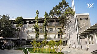
Pixxel (pik·sl) is an Indian-American private space technology company building a constellation of the world's highest-resolution hyperspectral imaging satellites into a sun-synchronous orbit along with Aurora, its in-house Earth observation platform designed to convert satellite imagery into actionable insights.
EOS SAT-1 is an optical Earth observation satellite for agricultural land monitoring by EOS Data Analytics, Inc., a global AI-powered satellite imagery analytics provider. The space optics instrument and satellite manufacturer Dragonfly Aerospace built the satellite and equipped it with two high-resolution DragonEye cameras.