
Usk is a town and community in Monmouthshire, Wales, 10 miles (16 km) northeast of Newport. It is located on the River Usk, which is spanned by an arched stone bridge at the western entrance to the town. Usk Castle, above the town, overlooks the ancient crossing point. It developed as a small market town, with some industry including the making of Japanware, and with a notable prison built in 1841/2. In recent years Usk has become known for its history of success in Britain in Bloom competitions, winning the Large Village award in 2005. The resident population of the town in 2001 was 2,318, increasing to 2,834 at the 2011 census.

The River Usk rises on the northern slopes of the Black Mountain, Wales, in the westernmost part of the Brecon Beacons National Park. Initially forming the boundary between Carmarthenshire and Powys, it flows north into Usk Reservoir, then east by Sennybridge to Brecon before turning southeast to flow by Talybont-on-Usk, Crickhowell and Abergavenny after which it takes a more southerly course.

William Edwards was a Welsh Methodist minister who also practised as a stonemason, architect and bridge engineer.

Newport Castle is a ruined castle in Newport, Wales. It was built in the 14th century, probably by Hugh de Audley, 1st Earl of Gloucester or his son-in-law, Ralph, Earl of Stafford, with the purpose of managing the crossing of the River Usk. The castle was used as administrative offices for the collection of rent and dues from local tenants, and was also a residence and a garrison. In 1402 it was sacked by Owain Glyndŵr. It was in disrepair by 1522, and was taken by Oliver Cromwell's forces during the Civil War. Its use declined further in later centuries. It has been a Grade II* Listed building since 1951.

Abergavenny Castle is a ruined castle in the market town of Abergavenny, Monmouthshire, Wales, established by the Norman lord Hamelin de Balun c. 1087. It was the site of a massacre of Welsh noblemen in 1175, and was attacked during the early 15th-century Glyndŵr Rising. William Camden, the 16th-century antiquary, said that the castle "has been oftner stain'd with the infamy of treachery, than any other castle in Wales."

Llanfihangel Gobion is a village and rural parish of Monmouthshire, Wales, lying within the administrative community of Llanover.
Llangwm is a small rural village and former community, now in the community of Llantrisant Fawr, in Monmouthshire, south east Wales. It is located 3 miles (4.8 km) east of Usk, on the B4235 Chepstow to Usk road. The main village is at Llangwm Uchaf, with a smaller and more dispersed settlement about 1 mile (1.6 km) to the north-east at Llangwm Isaf .The other settlement in the community is Llansoy. In 2022 the community was abolished and merged with Llantrisant Fawr.

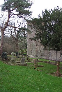
The Priory Gatehouse in Usk, Monmouthshire, Wales, is a surviving fragment of a Benedictine priory founded around 1135 and dissolved in 1536. It stands beside the main entrance to the churchyard. It is a Grade I listed building.

Monmouthshire is a county and principal area of Wales. It borders Torfaen and Newport to the west; Herefordshire and Gloucestershire to the east; and Powys to the north. The largest town is Abergavenny, with other large settlements being Chepstow, Monmouth, and Usk. The present county was formed under the Local Government (Wales) Act 1994, and comprises some sixty percent of the historic county. Between 1974 and 1996, the county was known by the ancient title of Gwent, recalling the medieval Welsh kingdom. The county is 850 km2 in extent, with a population of 95,200 as of 2020.
Monmouthshire is a county and principal area of Wales. It borders Torfaen and Newport to the west; Herefordshire and Gloucestershire to the east; and Powys to the north. The largest town is Abergavenny, with the other major towns being Chepstow, Monmouth, and Usk. The county is 850 km2 in extent, with a population of 95,200 as of 2020. The present county was formed under the Local Government (Wales) Act 1994, and comprises some sixty percent of the historic county. Between 1974 and 1996, the county was known by the ancient title of Gwent, recalling the medieval Welsh kingdom. In his essay on local government in the fifth and final volume of the Gwent County History, Robert McCloy suggests that the governance of "no county in the United Kingdom in the twentieth century was so transformed as that of Monmouthshire".
Pant-y-Goitre Bridge crosses the River Usk between Abergavenny and Usk near the village of Llanfair Kilgeddin. The bridge carries the B4598. It was constructed in 1821 by the engineer John Upton.

Crickhowell Bridge is an 18th-century bridge that spans the River Usk in Crickhowell, Powys, Wales. The main A4077 road to Gilwern crosses it. The bridge is claimed to be the longest stone bridge in Wales at over 128 metres (420 ft).

New Bridge crosses the River Usk at Newbridge-on-Usk between Usk and Caerleon. The bridge carries the B4236. It was constructed in 1779, probably by William Edwards, a prominent civil engineer of Pontypridd, or by a member of his bridge-building dynasty. The bridge has Grade II* listed building status.

Abergavenny Bridge,, crosses the River Usk at the boundary between Abergavenny and Llanfoist. The bridge carries the A4143. The bridge is of medieval origin, but was substantially reconstructed in the early 19th century, to support a tramroad, and in the mid 19th century, when the two bridges were combined.

Ynys Hafod, Henllys and Min Yr Afon, New Market Street, Usk, Monmouthshire, are three houses forming a continuous range in the centre of the town. Each house is a Grade II* listed building.

30 Bridge Street, Usk, Monmouthshire, is a building dating from the very early 15th century. In the 17th century the structure was used as a gaol and the Catholic martyr David Lewis was imprisoned there in 1678. 30 Bridge Street is a Grade II* listed building.

The Church of St Cadoc, Llangattock-Juxta-Usk, Monmouthshire is a parish church with its datable origins in the 15th century. The church was restored in 1827 and again in 1864–5. It is a Grade II* listed building.

The Church of St Michael, Llanvihangel Gobion, Monmouthshire is a parish church with datable origins to the 15th century. There is no record of a Victorian restoration, although one must have occurred, but there is documented evidence of a "light" reconstruction in 1925. Since the date, the church has barely been altered. It now is closed, having been declared redundant and is in the care of the Representative Body of the Church in Wales. It is a Grade II* listed building.

Pentwyn, Llanllowell, Monmouthshire is a farmhouse dating from the mid-16th century. The house is Grade II* listed, with the adjacent barn having its own Grade II listing.
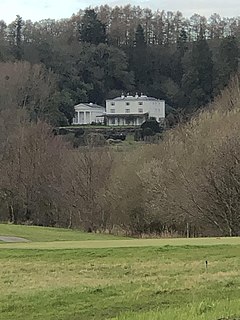
Glen Usk, Llanhennock, Monmouthshire is a country house dating from 1820. It was built for Sir Digby Mackworth, Bt. in the Neoclassical style. The house is Grade II* listed and the adjoining temple, and other associated structures, have their own Grade II listings.

